20th Century
Showing 61–72 of 261 results
-
![air france boucher]()
A very decorative world map by Lucien Boucher created for Air France published in Paris at atelier Perceval, 1939. This is one of the first maps of Air France which was founded in October 1933. Shows the beginning routes of the airline, extending west to the Americas and east to China. The route Paris-New York shown dotten because still in study (the first travel was in 1946). The whole world is filled with beautiful illustrations,…
- Dimension: 60 x 96 cm
- Place of publication: Paris
- Year: 1939
-
![]() Out of stock
Out of stockA very attractive chart of the heavens and the zodiacal constellations designed by Lucien Boucher for Air France published at Atelier Perceval, 1951. The amazing promotional poster, decorated with many attractive drawings and designs, shows the constellations of the northern and southern skies overlain by a globe showing Air France routes. In the four corners cherubs blowing into the skies and the Milky Way flowing through the constellations.The map is decorated with many particulars shaded in gold.
- Dimension: 35 x 58 cm
- Place of publication: Paris
- Year: 1951
-
![]() Out of stock
Out of stockStriking pictorial planisphere showing an elongated terrestrial globe with Air France routes in white, surrounded by a richly decorated border of landscapes. The map shows routes east to Japan and west to the Americas. A significant expansion of the airline network. Numerous vignettes illustrate special landmarks, people and animals. Lucien Boucher is a commercial poster artist and illustrator born in Chartres in 1889 and died in 1971. Graduated from the Ecole de céramiques de Sèvres,…
- Dimension: 95 x 58 cm
- Place of publication: Paris
- Year: 1959
-
![]() Out of stock
Out of stockThe uncommon small version of the world map poster designed by Lucien Boucher in 1948 for Air France. The map shows routes east to Japan and west to the Americas. A significant expansion of the airline network. Numerous vignettes illustrate special landmarks, people and animals. Lucien Boucher is a commercial poster artist and illustrator born in Chartres in 1889 and died in 1971. Graduated from the Ecole de céramiques de Sèvres, he began his career…
- Dimension: 33 x 58 cm
- Place of publication: Paris
- Year: 1948
-
![]() Out of stock
Out of stockThe smal version of one of Boucher’s most remarkable promotional maps designed for Air France.
- Dimension: 35 x 58 cm
- Place of publication: Paris
- Year: 1952
-
![]() Out of stock
Out of stockDivertente planisfero disegnato da Luigi Roveri e Giuseppe Orliani per la compagnia aerea Alitalia e pubblicato a Roma nel 1975 presso l’editore Daniele Cerretti. Destinata all’infanzia questa carta geografica-pittorica ben si fonde con lo stile grafico degli autori che avendo collaborato per la rivista Miao, nota per le sue storie senza testo, riesce a descrive in maniera sintetica ma riuscita i costumi e le peculiarità delle varie aree del mondo. Luigi Roveri è stato un…
- Dimension: 43 x 65 cm
- Place of publication: Rome
- Year: 1976
-
![]() Out of stock
Out of stockFascinating illustrated map, designed for post-World War II school audiences, showing Antarctica as a then still largely unknown territory, a symbol of scientific challenge and conquest. Prominent in the center is a polar view of Antarctica, showing the main areas of international influence-the United Kingdom, the United States, Norway, France, Australia, and New Zealand-underscoring the growing geopolitical interest in the white continent during the Cold War years and in the run-up to the International Geophysical…
- Dimension: 40 x 49 cm
- Place of publication: Brescia
- Year: 1956
-
![]() Out of stock
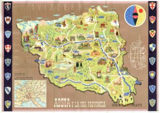
Out of stockManifesto pubblicitario che mostra disegno della Valle d’Aosta con monumenti e figure in abiti tradizionali affiancato da oggetti e monumenti tipici del territorio. In alto a destra figura allegorica e stilizzata delle tipicità della regione con fucile, sci, racchetta da tennis, picozza, corda e macchina fotografica. In basso a sinistra riquadro con carta del nord Italia e lungo i lati successione di otto stemmi per parte. Al verso fotografie di diverse località ed un testo illustrativo delle caratteristiche della Valle d’Aosta. Pubblicato dall’Ente Nazionale Industrie Turistiche presso lo stampatore Pizzi & Pizio nel 1937-38. Confronta Collezione Salce, Museo Nazionale 05165
- Dimension: 48 x 68 cm
- Place of publication: Rome
- Year: 1937
-
![]() Out of stock
Out of stockDelizioso atlantino storico dedicato ai fanciulli che mostra, con l’ausilio di curiose piccole carte geografiche traforate, la storia delle suddivisioni territoriali dal 1848 al 1929. Edizione speciale a cura della Società Unica di Torino. Edito a Milano nel 1930 da Giovanni De Agostini.
- Dimension: 23 x 15,5 cm
- Place of publication: Milan
- Year: 1930
-
![atlas gastronomy]()
Raro atlante gastronomico, pubblicato in 100 esemplari numerati, che offre un viaggio attraverso le regioni di Francia alla scoperta dei piatti e ricette tipiche di ogni territorio. L’atlante è corredato da 13 splendide mappe pittoriche disegnate da Libis che sottolineano attraverso belle e vivaci vignette le specialità gastronomiche, i vini e le bevande delle città principali. Le mappe sono accompagnate da testi che descrivono le peculiarità gastronomiche di ogni provincia comprendendo anche l’elenco dei principali…
- Dimension: 21,5 x 27 cm
- Place of publication: Paris
- Year: 1938
-
![pictorial map australia]() Out of stock
Out of stockAmong the most fascinating works by British cartographer and illustrator Leslie MacDonald Gill is this pictorial map of Australia published in London in 1946. Made in the immediate postwar period, this map is an effective visual summary of Australia’s natural wealth and industrial potential, revealing not only geographical and economic data but also a strong political and symbolic message. In the lower right pane, text reads, “Australia has emerged from the World War with increased…
- Dimension: 49 x 74 cm
- Place of publication: London
- Year: 1946
-
![mappa pittorica austria]()
The Pictorial Map of Austria (1952): Modern Design and the Marshall Plan In post-World War II Europe, tourism was not merely a leisure pursuit but a vital engine for economic recovery. A stellar example of this era is the large pictorial map of Austria published in 1952 by the Press- and Information-Service of the Austrian Federal Government. Designed by the young South African artist William G. Slattery, this map transcends its geographic function, serving as…
- Dimension: 120 x 81 cm
- Place of publication: Vienna
- Year: 1952