20th Century
Showing 37–48 of 213 results
-
![]() Out of stock
Out of stockPictorial map of the Basque region designed by G. H. Oñativia for the Banco de Bilbao.
- Dimension: 61 x 95 cm
- Place of publication: Tolosa
- Year: 1940
-
![]()
This superb pictorial map of Spain was created by M. Heredero. The map shows the history, culture and natural resources in Spain, as well as the modes of telecommunication and transportation. The map is densely filled with tiny images of all of the types of products produced in each region, historical figures and costumes, famous landmarks, and three-dimensional representations of the mountains. Single black lines criss-cross the country to show the lines of telecommunication, double-black…
- Dimension: 104 x 75 cm
- Place of publication: San Sebastian
- Year: 1957
-
![]() Out of stock
Out of stockLarge pictorial map of Stockholm designed in 1953 by Curt Blixt showing also lovely views of the most important places of the city and historical vignettes. Curt Blixt began his career as a chaser at jeweller W.A. Bolin. In order to develop his artistic talent, Curt took evening classes at the Technical School (now known as Konstfack). After completing his studies, he was employed as an illustrator and designer at Esselte Reklam at Vasagatan in…
- Dimension: 70 x 105 cm
- Place of publication: Stockholm
- Year: 1953
-
![]()
[Switzerland] Die vielgestaltige Schweiz. Svizzera dai mille volti. La Suisse en images. Exploring Switzerland
More Info € 300,00A magnificent large and very decorative pictorial map folded in self cover surrounded by notes and illustration of flowers, with the compass rose in the center. Shows buildings. landmarks, peoples, animals, roads, railroads, waterways, churches, tourist attractions, geographical features and places of interest. A short guide by Hans Jenny, and illustrations on verso. Designed by Eduard Imhof after a drawn by Otto Muller. Published by the Swiss National Tourist Office in Bern in 1939. Folded…
- Dimension: 76 x 116 cm
- Place of publication: Bern
- Year: 1939
-
![]()
A fine art decò map showing the International Railway Connections of Switzerland published by Swiss Federal Railroads in 1937.
- Dimension: 46 x 48 cm
- Place of publication: Bern
- Year: 1937
-
![]() Out of stock
Out of stockAn uncommon pictorial map of The British Isles designed by Cecil Meyer showing the railway system with the major cities symbolized by the most important buildings, usually a church or lordly manor. Bordered by coats of arms from the cities of the British Isles and with decorative cartouche for Scotland, England, Ireland and Wales, plus a decorative compass rose. On verso: Ten panels, showing landmarks, with brief explanatory text and coat of arms, and text…
- Dimension: 57 x 45 cm
- Place of publication: London
- Year: 1935
-
![]()
A rare satirical caricature showing the British Empire as a mighty colossus standing astride the Dardanelles facing the Sea of Marmara, the Bosporus, and the Black Sea. The fine lithograph refers to an episode in the Russo-Turkish War (1877-1878) when the Ottomans defeated by the Russians were aided by the British Empire. A warning to the world against Russia’s duplicity, but also against Great Britain itself, which, although a saviour here, nevertheless expresses a sinister…
- Dimension: 40 x 56 cm
- Place of publication: Bologna
- Year: 1877
-
![red cross boucher world map]()
Fine very decorative 1962 Lucien Boucher pictorial map of the world celebrates the Centenary of the Foundation of the Red Cross. (1863 – 1963). The map is embellished by a large compass rose, sea monster and whales in the oceans and especially with numerous vignettes mostly showing medical services and others highlighting world cultures as New York’s skyline, native Americans, llamas in South America, a geisha in Japan, camels in North Africa, the Giza Pyramids…
- Dimension: 59 x 93 cm
- Place of publication: Paris
- Year: 1962
-
![]() Out of stock
Out of stockDecorative map and game board celebrating the 1925 trip by air from Tokyo to the major cities of Europe
- Dimension: 54 x 78 cm
- Place of publication: Osaka
- Year: 1925
-
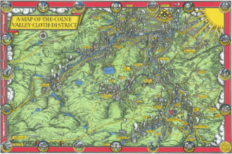
![]() Out of stock
Out of stockFine 1947 pictorial map by MacDonald Gill showing the Colne Valley Cloth District in Yorkshire, England.
- Dimension: 33 x 49 cm
- Place of publication: London
- Year: 1947
-
![]() Out of stock
Out of stockFascinating pictorial map of Sierra Leone showing through delightful vignettes the typical products and industries of the West African state at the time of British colonialism. At the top, two panels with imports and exports while the lower part is dominated by the legend with conventional signs, types of industries and a graphic list of vignettes with agricultural products. The map is undated but the right margin lists the most important historical events for the…
- Dimension: 50 x 38 cm
- Place of publication: London
- Year: 1925
-
![]() Out of stock
Out of stockA lovely and uncommon map of French equatorial Africa published in Paris by the pharmaceutical laboratories Neutroses-Vichy in 1939 at Petit Jean. The French Congo, Gabon, Oubangui-Chari (now Central African Republic) and Chad are symbolized by small vignette.
- Dimension: 310 x 210 mm
- Place of publication: Paris
- Year: 1939