20th Century
Showing 49–60 of 261 results
-
![]() Out of stock
Out of stockA pictorial map designed by Amsterdam graphic artist Frans Meyer and published in 1947 by the “Stichting 1940-1945,” a foundation established to raise funds for members of the resistance and their families, representing one of the most significant visual records of the German occupation of the Netherlands during World War II. The map, printed in full-color lithography and enhanced by an illustrated frame with twenty vignettes, reflects the dramatic transformation of the Netherlands between the…
- Dimension: 67 x 98 cm
- Place of publication: Amsterdam
- Year: 1947
-
![]() Out of stock
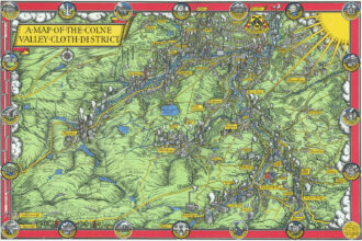
Out of stockFine 1947 pictorial map by MacDonald Gill showing the Colne Valley Cloth District in Yorkshire, England.
- Dimension: 33 x 49 cm
- Place of publication: London
- Year: 1947
-
![pictorial map india]() Out of stock
Out of stockLarge pictorial map showing India, Burma and Ceylon published in London in 1950 by the historic Philip & Tacey publishing house. The map is dominated by vivid vignettes illustrating agricultural products, natural resources, local activities, monuments and folkloric aspects. Notable depictions include the northwestern regions and the Rajastahn characterized by camels crossing the Thar Desert, evoking the ancient tradition of caravans, the Himalayan mountains depicted with snow-capped peaks, and major cities with historic buildings and…
- Dimension: 75 x 98 cm
- Place of publication: London
- Year: 1950
-
![]() Out of stock
Out of stockFascinating pictorial map of Sierra Leone showing through delightful vignettes the typical products and industries of the West African state at the time of British colonialism. At the top, two panels with imports and exports while the lower part is dominated by the legend with conventional signs, types of industries and a graphic list of vignettes with agricultural products. The map is undated but the right margin lists the most important historical events for the…
- Dimension: 50 x 38 cm
- Place of publication: London
- Year: 1925
-
![]() Out of stock
Out of stockThis stunning, large, and highly detailed map of Africa was published in 1914, shortly before the outbreak of World War I. It highlights the maritime routes between Germany and the African continent, operated by various German shipping companies: Woermann-Linie, Deutsche Ost-Afrika Linie, Hamburg-Amerika Linie, and Hamburg-Bremer Afrika-Linie. These companies were established as alternatives to British shipping lines, representing Germany’s maritime efforts to secure a presence in Africa. In the upper right corner, the map includes…
- Dimension: 78 x 100 cm
- Place of publication: Lipsia
- Year: 1914
-
![]() Out of stock
Out of stockA lovely and uncommon map of French equatorial Africa published in Paris by the pharmaceutical laboratories Neutroses-Vichy in 1939 at Petit Jean. The French Congo, Gabon, Oubangui-Chari (now Central African Republic) and Chad are symbolized by small vignette.
- Dimension: 310 x 210 mm
- Place of publication: Paris
- Year: 1939
-
![]() Out of stock
Out of stockA large pictorial map by J. Choain Audiberti of French Equatorial Africa showing several African countries including Nigeria, Chad, Cameroon, Gabon, Central African Republic and the Belgian Congo. The map is illustrated with lovely vignettes of people, farming, trees, mountains and animals like tigers, camels, horses, antelopes, ostriches, giraffes, elephants. It is completed by ships at sea, cars driving through the desert, planes flying over the map; at bottom a fine cartouche with a traditional African village scene surrounding the larger map of Africa. Published in Paris, 1950
- Dimension: 120 x 80 cm
- Place of publication: Paris
- Year: 1950
-
![]() Out of stock
Out of stockA lovely and uncommon map of French west Africa published in Paris by the pharmaceutical laboratories Neutroses-Vichy in 1939 at Petit Jean. The Morocco, Tunisia, Algeria, Niger, Mali, Mauritania, Senegal, Guinea, and the other french regions are symbolized by small vignette.
- Dimension: 310 x 210 mm
- Place of publication: Paris
- Year: 1939
-
![]() Out of stock
Out of stockA colourful promotional map of French West Africa by Leon Craste designed to promote tourism and commercial development in French West Africa, which continued to operate as a political federation until 1960. Published by French Ministry of Overseas in 1951. The map shows the area from Atlantic Ocean to Chad and Cameroon and from Algeria to Togo including the colonies of Mauritania, Sudan, Senegal and Ivory Coast and some of the Portuguese territories like Guinea-Bissau, Gambia, Ghana and Nigeria. Illustrations of major cities, agricultural products, natural resources and exotic animals are on display, along with an inset showing French possessions relative to the entire continent.
- Dimension: 120 x 80 cm
- Place of publication: Paris
- Year: 1951
-
![]() Out of stock
Out of stockImportant tourist poster by Guy Georget, commissioned by Air France to promote travel with the airline Air Afrique and published in Paris by the Serma atelier in 1961. The large poster, designed by Georget with the geometric style and colors typical of African masks, shows the western part of the continent with the A.O.F. in evidence. The A.O.F. was part of the French colonial empire until 1960 and included territories such as the Ivory Coast,…
- Dimension: 98 x 151 cm
- Place of publication: Paris
- Year: 1961
-
![]() Out of stock
Out of stockA decorative world map showing the significant expansion of the airline network from Paris to Europe, Africa, Americas, Asia and Australia. The map was published to advertise also the comfortable aircraft Vickers Viscount a new British medium-range turboprop airliner first flown in 1948, the first such aircraft to enter service in the world. The Viscount was well received by the public for its cabin conditions, which included pressurisation, reductions in vibration and noise, and panoramic windows. It became one of the most successful and profitable of the first post-war transport aircraft. The large map, published by Atelier Perceval as depliant brochure in 1950 is decorated by a compass rose. On the verso pics of the aircraft and description of its comforts and some photos of the most beautiful destinations.
- Dimension: 49 x 88 cm
- Year: 1950
- Place of publication: Paris
-
![]() Out of stock
Out of stockA decorative world map showing the significant expansion of the airline network from Paris to Europe, Africa, Americas, Asia and Australia. The map was published to advertise also the comfortable aircraft Vickers Viscount a new British medium-range turboprop airliner first flown in 1948, the first such aircraft to enter service in the world. The Viscount was well received by the public for its cabin conditions, which included pressurisation, reductions in vibration and noise, and panoramic windows. It became one of the most successful and profitable of the first post-war transport aircraft. The large map, published by Atelier Perceval as depliant brochure in 1950 is decorated by a compass rose. On the verso pics of the aircraft and description of its comforts and some photos of the most beautiful destinations.
- Dimension: 49 x 88 cm
- Year: 1950
- Place of publication: Paris