Germany
Showing 1–12 of 25 results
-
![]()
Superb map of the German Empire showing northern Europe, from the eastern tip of England to Poland, and extends from the North Sea to Venice and the coast of Croatia published by Johan Baptiste Vrients for the 1612 edition of Ortelius’ Theatrum Orbis Terrarum, the first modern atlas of the world. This plate was acquired by Vrients in 1603 from the engraver Franz Hogenberg (see his signature in the centre of the lower-left cartouche) and incorporated…
- Year: 1612
- Dimension: 381 x 490 mm
- Place of publication: Antwerp
-
![]() Out of stock
Out of stockDetailed topographical map of Berlin published in 1962, very shortly after the construction of the Berlin wall which isolated the west part from the east until 1989, by the Presse- und Informationsamt des Landes.
The powerful map is interesting also because it is before the construction of the second wall beginning in June 1963, which established the so-called death strip.
At top large title and the the coat of arms of Berlin west (a black bear on a white shield) introduced in 1954.- Dimension: 60 x 83 cm
- Place of publication: Berlin
- Year: 1962
-
![]()
Fine and detailed map of Cologne and Dusseldorff from the Mercator Hondius “Atlas Minor” published in Amsterdam in 1648 at Jannsonius. In 1607 Jodocus Hondius published a reduced size version of Mercator’s “Atlas”, itself suitably titled “Atlas Minor”. The maps were copied from those of the great cartographer Mercator of around 1580-90 or were reductions of Hondius’ own maps of 1606. Almost 20 years later Joannes Janssonius commissioned a new set of …
- Year: 1648
- Dimension: 190 x 140 mm
- Place of publication: Amsterdam
-
![]()
Lovely small map of Upper Sachsen and Schlesien centered roughly on Meissen with place names, rivers and forests. From the Mercator Hondius “Atlas Minor” published in Amsterdam in 1648 at Jannsonius. In 1607 Jodocus Hondius published a reduced size version of Mercator’s “Atlas”, itself suitably titled “Atlas Minor”. The maps were copied from those of the great cartographer Mercator of around 1580-90 or were reductions of Hondius’ own maps of 1606.
- Year: 1648
- Dimension: 195 x 145 mm
- Place of publication: Amsterdam
-
![]()
Very rare map engraved by Elias Baeck from ?Der curiose und .. Nssliche Dollmetscher..? published in Augsburg in 1748. The map has decorative cartouche and a nice original colouring. Missing in many reference.
- Year: 1748
- Dimension: 225 x 165 mm
- Place of publication: Augsburg
-
![]()
[Italian only] Eccezionale pianta prospettica della citt di Brescia incisa e pubblicata da Donato Rascicotti nella inedita e sconosciuta versione con il cartiglio nella parte destra poi eliminato nella versione definitiva a causa della lunghezza del testo descrittivo che non poteva essere contenuto. Anche il cartiglio a sinistra contenente la dedica risulta vuoto a conferma del fatto che si tratti di primissima tiratura di prova. In basso 134 rimandi …
- Year: 1648
- Dimension: 205 x 150mm
- Place of publication: Amsterdam
-
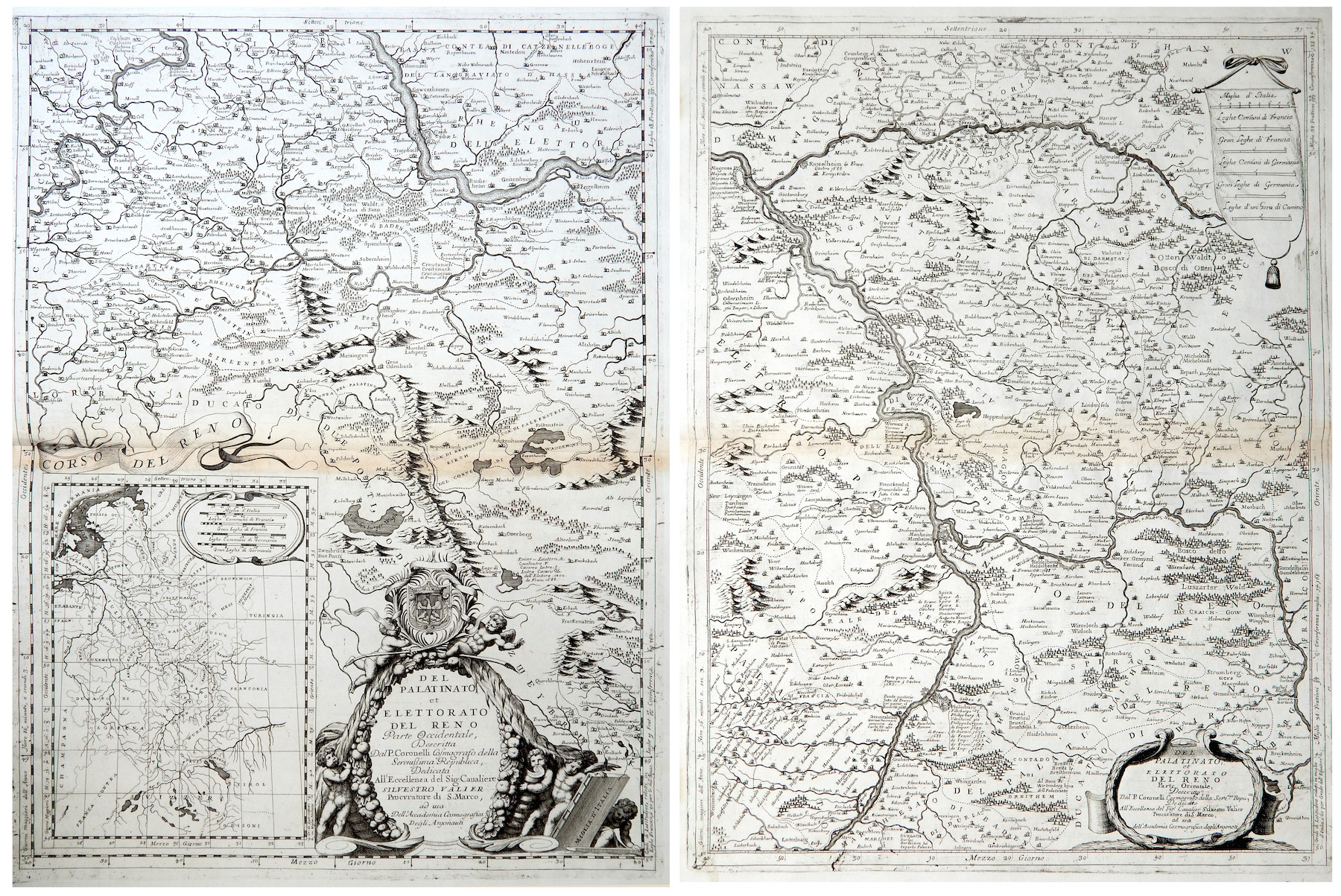
![]()
Del Palatinato et Elettorato del Reno parte Occidentale… / Del Palatinato et Elettorato del Reno parte Orientale
More Info € 600,00Very detailed and decorative map in two sheets of Rhine Valley from Coronelli’s Corso Geografico Universale published in Venice in 1690. Inset map of the entire River. Vincenzo Maria Coronelli is widely recognised as one of Italy?s most famous and greatest cartographers. He received an ecclesiastical education at the convent of the Minor Conventuals and also studied theology in Rome. However, his interests in geography and cartography were awoken early in his ecclesiastical career and never supp
- Year: 1690
- Dimension: 605 x 450 mm each
- Place of publication: Venice
-
![]() Out of stock
Out of stockGrande carta geografica pittorica della Germania concepita in collaborazione da Fritz Hölzel (topografia), Karl-Heinz Schelling (illustrazioni), Manfred Langhans-Ratzeburg e pubblicata a Darmstadt nel 1954 con la direzione di Karl-Otto Gassdorf. La mappa mostra l’intera nazione “dalle Alpi al mare” con centinaia di deliziose vignette a sottolineare gli aspetti storici, architettonici, industriali, produttivi e turistici della Germania. Il sottotitolo fa presente che si tratta della parte prima della mappa poichè seguirà una seconda parte (si noti anche il piccolo richiamo nel margine destro fra le lettere F e G) con la descrizione del territorio lungo il confine con la Polonia, carta che per motivi di opportunità politica non vedrà mai la luce.
- Dimension: 86 x 123 cm
- Place of publication: Darmstadt
- Year: 1954
-
![]()
A lovely original antique miniature map centered on Bamberg showing the region of Franconia in Germany.
From the uncommon “Neu aussgeffertigter kleiner Atlas” by J. U. Muller published in Franckfurt in 1692 at Johann Philip Andrea.
The map was engraved with great care by G. Karsch e G. Bodeneher.
See G. King “Miniature antique maps” (1st edition) pag.136- Dimension: 70 x 80 mm
- Place of publication: Frankfurt
- Year: 1702
-
![]() Out of stock
Out of stockBeautifully engraved map of ancient Germany showing in hight details the northern Europe from the Adriatic to the Baltic and Netherlands.
Really interesting the latin nomenclature of the cities, town rivers and mountains.
From the 1624 final edition of Ortelius’s “Parergon in quo Veteris Geographiae aliquot tabulae… – Nomenclator Ptolemaicus” with the text by Balthasar Moretus.
Ortelius’s Parergon began as a companion to his Theatrum but eventually it became an independent work. In fact, this collection of maps of the ancient world was so significant that it became the model for all historical atlases published throughout the seventeenth century. The maps and plates in the Parergon have to be evaluated as the most outstanding engravings depicting the wide-spread interest in classical geography in the 16th century (Koeman).- Year: 1624
- Dimension: 366 x 472 mm
- Place of publication: Antewerp
-
![]()
A beautiful guide in 48 pages to the gastronomic delights of Germany richly illustrated by Herman Schneider. Published in Berlin in 1953. In the end, folded, a fine pictorial map of Germany.
- Dimension: 58 x 40 cm
- Place of publication: Berlin
- Year: 1953
-
![]()
A beautiful colored pictorial map with inset map of Europe showing location of Nazi Germany, promoting tourism. Showing major cities, historical people and places of interest, agriculture, industry, sports, Berlin and 1936 Olympic Games. On verso map of Germany showing roads and railways, inset map of air routes, and text and tourist information. Drawn by Riemer and published in Berlin by Reichsbahnzentrale fur den Deutschen Reiseverkehr in 1941.
- Dimension: 77 x 57 cm
- Place of publication: Berlin
- Year: 1941