Lombardy
Showing 1–12 of 137 results
-
![]() Out of stock
Out of stockDetailed map of Brescia in northern Italy from Ortelius’ Theatrum Orbis Terrarum, the first modern atlas of the world. The map is oriented with east at the top and shows Lago gi Garda, Brescia, Lago d’Iseo, Lago di Idro. From the French edition of Theatrum published in Antwerp, 1598.
- Dimension: 33 x 47 cm
- Place of publication: Antwerp
- Year: 1598
-
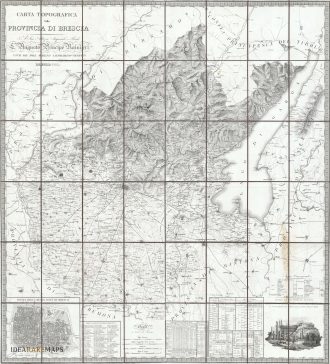
![antica mappa carta geografica provincia di Brescia]() Out of stock
Out of stockMagnificent map of Brescia dedicated to Giovanni Michele Ranieri published in Milan, 1826
- Dimension: 110 x 123 cm
- Place of publication: Milan
- Year: 1826
-
![]()
Grande acquaforte disegnata e incisa da Giuseppe Vasi che mostra con un tratto raffinatissimo la cattedrale di Santa Maria Assunta, il Duomo nuovo di Brescia, animata in primo piano da personaggi in conversazione. La bellissima e rara rappresentazione è firmata in basso a sinistra Joseph Vasi delin et sculpt . Al centro il titolo, la data e la dedica al cardinale Angelo Maria Querini (il cui busto in marmo scolpito da Antonio Calegari è posto…
- Year: 1742
- Dimension: 655 x 442 mm
- Place of publication: Rome
-
![]()
Nice lithograph by Mller-Wegmann showing the Swiss Italian Alps (M. Sissone; P. Bracone; Cima di Cantone; Cima di Castella; Castello; M. di Zocca; Pizzi Gemelli etc.). Published in Bern in 1879.
- Year: 1836
- Dimension: 270 x 385 mm
- Place of publication: London
-
![]()
Inedita e interessantissima veduta di Brescia intitolata “la conquista e cattura della famosa città fortificata di brescia” incisa all’acquaforte nel 1799 da artista anonimo ma dal tratto riconducibile alle produzioni cartografiche pubblicate a Lipsia nella fine del’700. La veduta mostra in primo piano l’esercito Russo-Austriaco che il 20 aprile 1799, durante la campagna italiana di Suvorov e nel più ampio contesto della guerra della seconda coalizione, arriva alle porte della città. Lo sfondo dell’intera rappresentazione…
- Dimension: 19 x 28 cm
- Place of publication: Lipsia
- Year: 1799
-
![]() Out of stock
Out of stockRara mappa del territorio di Brescia tratta dal Nouveau Petit Atlas – Atlas soluagé de son gros pesant Fardeau di Peter Vander Aa stampato a Leida nel 1714. L’atlante, conosciuto completo in una unica copia presente nella biblioteca di Leida, è composto di nove parti: una parte generale denominata “Nouveau Petit Atlas” e 8 parti con carte geografiche inerenti una specifica regione del mondo. Quasi tutte le mappe risultano essere rielaborazioni delle lastre incise da…
- Dimension: 14,5 x 19 cm
- Place of publication: Leiden
-
![]() Out of stock
Out of stockCurious map of Brescia according to the divisions by Friars Minor Capuchin. Published in Turin, 1643.
- Dimension: 33 x 22 cm
- Place of publication: Turin
- Year: 1643
-
![antca mappa brescia]() Out of stock
Out of stockCurious map of Brescia according to the divisions by Friars Minor Capuchin. Published in Milan, 1712.
-
![]()
[Brescia] Veduta di Brescia da Porta San Nazaro – Terra Antiqua, potens armis atque ubere glebe dedicata a Luigi Arici
More InfoLa più importante, ambita e rara veduta generale della città di Brescia
- Year: 1764
- Dimension: 1360 x 605 mm
- Place of publication: Brescia
-
![]() Out of stock
Out of stock[Mantova] Ducato di Mantova con parte del Dominio Veneto, del Milanese et altri Stati circonvicini
More InfoRare map of Mantua showing the Kingdom of Venice and Duchy of Milan
- Dimension: 33 x 50 cm
- Place of publication: Venice
- Year: 1680
-
![]() Out of stock
Out of stock[Mantua] Carta della provincia di Mantova compilata dietro i migliori materiali del colonnello conte F. Karacsay
More InfoRara carta geografica della provincia di Mantova che manca della scala e della graduazione geografica ma che propone un’accurata rappresentazione del territorio secondo i rilevamenti del colonnello Fedor von Karacsay che, nel sottotitolo, la dichiara «conforme à l orografia». Oltre alle consuete indicazioni di carattere politico ed economico ne compaiono altre relative alle istituzioni austriache vigenti: preture, ricevitorie doganali, confini di delegazioni e distretti. La carta si distingue per il preciso tratto grafico, l’elegante calligrafia…
- Dimension: 43 x 58 cm
- Year: 1840
-
![]() Out of stock
Out of stockExtremely scarce map of Milan one of the few engraved by George Paul Busch.
- Dimension: 28 x 36 cm
- Place of publication: Berlin
- Year: 1740