Greece - Malta - Cyprus
Showing all 10 results
-
![]() Out of stock
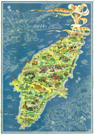
Out of stockPictorial map of Rhodes, the island of the sun or rose island in Greece by Egon Huber. Published by Ente Nazionale del Turismo Italiano in Milan at Pizzi & Pizzi, 1935. Shows roads, woods, forts, lighthouses, people in various recreational activities, etc. Also shows buildings, landmarks, ships and boats in white over blue sea. On verso 14 photos of Rodi as well as rich information about Rodi island. The list of the photos: “La citta…
- Dimension: 46,5 x 67 cm
- Place of publication: Milan
- Year: 1935
-
![]() Out of stock
Out of stockDetailed map of Crete published in 1866 by Dietrich Reimer and based on the representation of the island drawn by the English hydrographer, geologist and vice-admiral Thomas Abel Brimage Spratt (1881-1888). The interesting map also features an inset with the valley of Mylopotamos, a locality in the northern part of the island, in the prefecture of Rethymnon. It will be reprinted in 1897 (Cf. Bibliothèque nationale de France, GED-2736 ) with the addition in plate…
- Dimension: 25 x 54 cm
- Place of publication: Berlin
- Year: 1866
-
![]()
Nice map of northern Greece with the southern parts of present day Macedonia and Albania. Includes Athens. Strapwork title cartouche in the lower left corner. From the Mercator Hondius “Atlas Minor” published in Amsterdam in 1648 at Jannsonius with german text on verso. In 1607 Jodocus Hondius published a reduced size version of Mercator’s “Atlas”, itself suitably titled “Atlas Minor”. The maps were copied from those of the great cartographer Mercator of around 1580-90 or were reductions of Hon
- Year: 1648
- Dimension: 205 x 145 mm
- Place of publication: Amsterdam
-
![]() Out of stock
Out of stockVery decorative prospect view of Athens showing the major buildings and places of interest. From Corso Geografico Universale by Coronelli published in Venice in 1690. Vincenzo Maria Coronelli is widely recognised as one of Italy’s most famous and greatest cartographers. He received an ecclesiastical education at the convent of the Minor Conventuals and also studied theology in Rome. However, his interests in geography and cartography were awoken early in his ecclesiastical career and never suppressed.…
- Year: 1690
- Dimension: 610 x 458 mm
- Place of publication: Venice
-
![]() Out of stock
Out of stockBeautiful seven little maps on one sheet: A large map of Crete, with six smaller maps across the top showing the Ionian Islands of Kerkira (Corfu), Zakinthos (Zante), Milos, Naxos, Santorini and Scarpanto. The map of Crete names many places, rivers and mountain ranges. From the Mercator Hondius “Atlas Minor” published in Amsterdam in 1648 at Jannsonius with german text on verso. In 1607 Jodocus Hondius published a reduced size version of Mercator’s “Atlas”, itself suitably titled “Atlas Minor”.
- Year: 1648
- Dimension: 198 x 140 mm
- Place of publication: Amsterdam
-
![]()
Nautical chart from J. Roux’s “Carte de la Mer Mediterranee en douze feuilles? published in Marsile in 1764. Sanderson, The Sea Chart, p. 91. Rare. [cod.1193/15]
- Year: 1764
- Dimension: 800 x 545 mm
- Place of publication: Marsiglia
-
![]()
Well engraved view of the town of Corfu with its harbour and the citadel. Below with a text about the history of the town in Latin and German. Published in Augsburg by Leopold in 1725. Rare first edition with the privilege but before numbers.
- Year: 1725
- Dimension: 300 x 200 mm
- Place of publication: Augsburg
-
![pictorial map cyprus]()
A beautiful pictorial map of Cyprus by the Greek artist Spyros Vassiliou and published in Athens in February 1965 by the Government Press and Information Office. The map depicts famous mythological places and describes historical events through refined vignettes. On the lower right, a cartouche in classical style shows the population density divided by Turks and Greeks, while a second insert on the upper left highlights Cyprus’s position in the world. At the bottom, a…
- Dimension: 69 x 53 cm
- Place of publication: Athens
- Year: 1965
-
![]()
Very decorative and rare plan of the city of Candia on the island of Crete. From Coronelli’s Corso Geografico Universale published in Venice in 1690. Vincenzo Maria Coronelli is widely recognised as one of Italy?s most famous and greatest cartographers. He received an ecclesiastical education at the convent of the Minor Conventuals and also studied theology in Rome. However, his interests in geography and cartography were awoken early in his ecclesiastical career and never suppressed. He made ve
- Year: 1690
- Dimension: 450 x 600 mm
- Place of publication: Venice
-
![]() Out of stock
Out of stockMagnificent map of Euboea in the eastern Greece embellished by prospect view of Chalkis. The very fine map is engraved in a drape, being held aloft by a putto to reveal a view of the city of Chalkis, showing the straits with the castle. In the foreground a large Lion of Venice. All around a decorative floral baroque border. From Coronelli’s Corso Geografico Universale published in Venice in 1690. Vincenzo Maria Coronelli is widely recognised…
- Year: 1690
- Dimension: 450 x 605 mm
- Place of publication: Venice