Piedmont - Aosta Valley
Showing 1–12 of 28 results
-
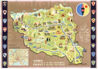
![]()
Manifesto pubblicitario che mostra disegno della Valle d’Aosta con monumenti e figure in abiti tradizionali affiancato da oggetti e monumenti tipici del territorio. In alto a destra figura allegorica e stilizzata delle tipicità della regione con fucile, sci, racchetta da tennis, picozza, corda e macchina fotografica. In basso a sinistra riquadro con carta del nord Italia e lungo i lati successione di otto stemmi per parte. Al verso fotografie di diverse località ed un testo illustrativo delle caratteristiche della Valle d’Aosta. Pubblicato dall’Ente Nazionale Industrie Turistiche presso lo stampatore Pizzi & Pizio nel 1937-38. Confronta Collezione Salce, Museo Nazionale 05165
- Dimension: 48 x 68 cm
- Place of publication: Rome
- Year: 1937
-
![]()
Rare copper engraving with original (uncommon) color. From “Piante delle citt , piazze e castelli fortificati…dello Stato di Milano” by G.B. Sesti published in Milan in 1707. Sold with a second leaf with the description of the town. [cod.337/15]
- :
- Dimension: 195 x 150 mm
- Place of publication: Milan
-
![]() Out of stock
Out of stockInteresting town plan of the walled city of Arona on the Lake Maggiore form the rare Schauplatz des Krieges In Italien, Oder Accurate Beschreibung der Lombardey by Thomas Fritschen published in Leipzig in 1702.
- Year: 1702
- Dimension: 70 x 130 mm
- Place of publication: Lipsia
-
![]()
A beautiful map with the best and interesting footpaths around Courmayeur. In the top left corner a list of the mountain trails for an enjoyable and safe experience. At bottom left the Cinzano ad for its vermouth. The uncommon lithograph map drawn by Gino Veragnez-Marino was published by Guide Illustrate Reynaudi for the local tourist office in 1920 circa.
- Dimension: 24 x 29 cm
- Place of publication: Turin
- Year: 1920
-
![]() Out of stock
Out of stockNorthern Italy’s detailed map stands out due to its beautiful representation of the landscape and the innovative approach of marking not only the altitude of the mountains but also of the towns in the area. The warning in the bottom right-hand corner, placed under the legend of the conventional signs, is significant: “this map follows the one in a single sheet engraved and published by the Royal Corps of Staff”; therefore, the map is related…
- Dimension: 60 x 83 cm
- Place of publication: Turin
- Year: 1859
-
![]()
A rare panoramic view of the city of Cazal in Monferrato, Italy. Below a legend with four key-point.
- :
- Dimension: 315 x 210 mm
- Place of publication: Paris
-
![]() Out of stock
Out of stockCorso del Po per la Lombardia dalle sue fonti fino al mare co’ fiumi che in esso scaricano …
More InfoImportante e grande carta geografica incisa in rame da Antonio Barbey su tre fogli uniti che mostra l’intero Corso del fiume Po attraverso l’Italia settentrionale. Basata sui rilevamenti del cartografo Agostino Cerruti e pubblicata a Roma da Domenico de Rossi nel 1703. Nell’angolo inferiore sinistro vi è un cartiglio contenente il titolo “Dato in Luce da Domenico de Rossi dalle sue Stampe in Roma alla Pace / con licenza de Superiori, e Priuilegio del Sommo…
- Dimension: 58 x 120,5 cm
- Place of publication: Rome
- Year: 1703
-
![]() Out of stock
Out of stockFine Homann’s map of the Po River
- Dimension: 119 x 52 cm
- Place of publication: Nuremberg
- Year: 1735
-
![]() Out of stock
Out of stockCursus Padi per Longobardiam a fonte usque ad ostia… et adiacentibus Ducatibus ac Principatibus
More InfoFirst edition of the large Seutter’s map in three sheets showing the entire course of the Po river, from its source to its mouth, with a detailed representation of the neighbouring territories: Savoy, Piedmont, Monferrato, Lombardy, Parma, Modena, Ferrara, Bologna and Veneto. In the beautiful cartouche in the lower left-hand corner of the first plate, the title reveals that the three parts were destined to be joined together to form a single image ‘Tribus combinandis…
- Dimension: 57,5 x 131 cm
- Place of publication: Augsburg
- Year: 1734
-
![]()
Interesting town plan of the walled city of Valenza from the rare Schauplatz des Krieges In Italien, Oder Accurate Beschreibung der Lombardey by Thomas Fritschen published in Leipzig in 1702.
- Year: 1702
- Dimension: 70 x 130 mm
- Place of publication: Lipsia
-
![]()
Nice small map covering the Monferrato in Pidmont and centered on Asti From the Mercator Hondius “Atlas Minor” published in Amsterdam in 1648 at Jannsonius with german text on verso. In 1607 Jodocus Hondius published a reduced size version of Mercator’s “Atlas”, itself suitably titled “Atlas Minor”. [cod.334/15]
- Year: 1648
- Dimension: 203 x 150 mm
- Place of publication: Amsterdam
-
![]()
Interesting town plan of the walled city of Novara from the rare Schauplatz des Krieges In Italien, Oder Accurate Beschreibung der Lombardey by Thomas Fritschen published in Leipzig in 1702.
- Year: 1702
- Dimension: 70 x 130 mm
- Place of publication: Lipsia