Sicily
Showing 1–12 of 21 results
-
![etna sicily]() Out of stock
Out of stockSuperb pictorial bird’s-eye view of Mount Etna drawn by the legendary illustrator Heinrich Caesar Berann and published in 1953 by the Catania Tourist Board. This charming tourist map is illustrated in baroque style with decorative borders and an antique-looking map of Catania in the left side-panel. On the verso are photographs of Etna and its environs, accompanied by information about climbing the volcano. Heinrich Caesar Berann (1915 – 1999) was an Austrian painter and cartographer. He achieved…
- Dimension: 43 x 62 cm
- Place of publication: Genoa
- Year: 1953
-
![antica carta sicilia]() Out of stock
Out of stockAn uncommon map of Sicily based on the map of the Royal Topographical Office of Naples published in 1826. The map, published as a loose sheet, is not dated, but it is probably one of the many representations of the island published around 1860 to meet the demands of a market attentive to the political and military events of that period. In April 1860 the revolt of the city of Palermo against the Bourbons of…
- Dimension: 65 x 50 cm
- Place of publication: Turin
- Year: 1860
-
![mappa sicilia trasporti]() Out of stock
Out of stockFascinating propaganda poster displaying the Mussolini government’s plan to address the issue of communication routes in Sicily. The map depicts the island with clearly highlighted road and rail connections, categorized by color to indicate their operational status, planned developments, and ongoing construction. Additionally, the map includes indications of naval routes from Palermo to Naples, Cagliari, Libya, and Tunisia. It offers an intriguing opportunity to examine the evolution of transportation in Sicily. For example, it’s noteworthy…
- Dimension: 30 x 45 cm
- Place of publication: Milan
- Year: 1930
-
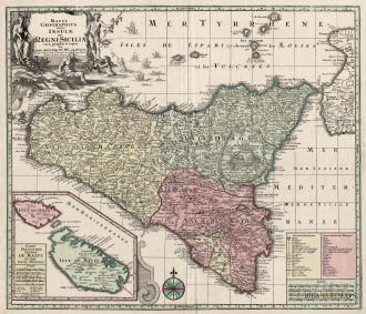
![]()
An extremely decorative, large, fine old colour example of De Wit’s rare map of Sicily. It shows in detail the cities of Messina, Milazzo, Palermo, Catania and Trapani.
It is considered one of the most beautiful and decorative maps of Sicily from the XVII century. This example is in exceptional old original colour.
The map is embellished with a compass rose, sailing ships, a dedication cartouche and especially, elaborate views of the major cities and ports of Sicily. From Atlas Major by F. De Witt published in Amsterdam in 1680.- Year: 1680
- Dimension: 580 x 500 mm
- Place of publication: Amsterdam
-
![antica mappa sicilia malta]() Out of stock
Out of stockA stunning map of Sicily published by M. Seutter in 1730. Inset at bottom a nice map of Malta and Gozo. Showing also the Etna erupting.
- Year: 1730
- Dimension: 580 x 500 mm
- Place of publication: Augsburg
-
![]()
A rare and early separately issued plan of Messina published by Matteo Florimi in Siena, 1600 circa. The plan covers the city in its entirety and showing at bottom the coast of Calabria with the city of Reggio on the left. Embellished by rare original colours and many vessels in the sea and harbour. Below a key listing 167 points of interest.
- Dimension: 37 x 45,5 cm
- Place of publication: Siena
- Year: 1600
-
![]() Out of stock
Out of stockView of Palermo from “Atlas Cureiux” published in Paris in 1705. [cod.474/15]
- Year: 1705
- Dimension: 230 x 170 mm
- Place of publication: Paris
-
![]()
A rare prospect view of Palermo, including a legend in the lower part published in 1720 by the Chereau brothers.
- Year: 1720
- Dimension: 136 x 208 mm
- Place of publication: Paris
-
![]() Out of stock
Out of stockRare copper engraving of Palermo in Sicily from Theatro delle città d’Italia, con nova aggiunta by Pietro Bertelli, pubblished by Francesco Bertelli in 1629.
- Year: 1629
- Dimension: 110 x 170 mm
- Place of publication: Padova
-
![]() Out of stock
Out of stockDeliziosa carta geo-pittorica che mostra l’area di Palermo disegnata da Aldo Cigheri nel 1950 commissionata per scopi turistici e promozionali. La mappa ricchissima di vignette, piccole illustrazioni, vedute ed elementi folkloristici mostra anche le principali vie di collegamento verso le altre città più importanti della Sicilia. Pubblicata a Genova presso la litografia S.A.I.G.A. nel 1950 a cura dell’Ente Provinciale per Turismo di Palermo Aldo Cigheri (1909–1995) è stato un pittore italiano che ha svolto un…
- Dimension: 23 x 30 cm
- Year: 1950
- Place of publication: Genoa
-
![antique map palermo sicily]() Out of stock
Out of stockElegante pianta topografica di Palermo disegnata da E. Sanzo e pubblicata dall’editore Remo Sandron in occasione della “IV Esposizione Nazionale Italiana”. In alto a sinistra, sotto lo stemma della città e il titolo, una piccola veduta dell’esposizione tenuta nei pressi di via Principe di Villafranca ed evidenziata in pianta dal colore verde. La bella e grande rappresentazione, stampata in litografia a quattro colori, è completata ai lati da una ricchissima legenda con tutti i punti…
- Dimension: 47 x 67 cm
- Place of publication: Palermo
- Year: 1892
-
![]() Out of stock
Out of stockDeliziosa carta geo-pittorica disegnata da Aldo Cigheri che mostra la provincia di Ragusa in Sicilia con in evidenza i prodotti, le costruzioni e gli elementi folkloristici più importanti e caratteristici dell’area. Pubblicata a Genova presso la litografia S.A.I.G.A. nel 1956 a cura dell’Ente Provinciale per Turismo di Ragusa. Aldo Cigheri (1909–1995) è stato un pittore italiano che ha svolto un ruolo di fondamentale importanza nel panorama artistico XX secolo soprattutto nel campo dell’illustrazione pubblicitaria. Con…
- Dimension: 23 x 31 cm
- Place of publication: Genoa
- Year: 1956