America
Showing 1–12 of 43 results
-
![]()
[Bolivia] Mapa de la Republica de Bolivia mandado publicar pr el Gobierno de la Nacion en la Administracion del Presidente Doctor José Maria Linares… Levantado y organindo en los años de 1842 à 1859 Por el Teniente Coronel Juan Ondarza, Commandante Juan Mariano Mujia y Mayor Lucio Camacho.
More Info € 4.500,00Rara, grande e dettagliatissima mappa murale della Bolivia disegnata da Juan Ondarza e pubblicata nel 1859 da J.H. Colton. Si tratta del primo studio scientifico del territorio della Bolivia e uno dei momenti più alti nella storia della cartografia dell’America Latina del XIX secolo. Questa spettacolare carta mostra la Bolivia alla sua massima estensione storica, prima che cedesse vaste quantità del suo territorio a seguito di guerre e incidenti diplomatici. Stampata a New York da…
- Dimension: 130 x 180 cm
- Place of publication: New York
- Year: 1859
-
![]()
An exceptional 1932 bird’s eye view map of the city of Quebec, Canada by Samuel Herbert Maw. The densely filled map displays parks, buildings, named streets and historic notations embellished by numerous coats of arms and a large compass rose. Born in England, Maw was an architect, delineator, etcher, cartographer and designer. After winning the Sloane Medallion from the Royal Institute of British Architects in 1905 and showing at the Royal Academy in London in…
- Year: 1932
- Dimension: 850 x 650 mm
- Place of publication: Toronto
-
![]() Out of stock
Out of stockInteresting map of Newfoundland and Cap Breton Island, along with neighbouring Islands, including St. Pierre Michelon. From Atlante Novissimo, illustrato ed accresciuto sulle osservazioni, e scoperte fatte dai piu’ celebri e piu’ recenti cartografi by Antonio Zatta published in Venice in 1779. [cod.1170]
- Year: 1779
- Dimension: 420 x 315 mm
- Place of publication: Venice
-
![]() Out of stock
Out of stockA finely engraved copper plate map that covers Chili and most of Argentina. Good detail of the region around Buenos Ayres and the Rio de la Plata. Santiago here is named Rioja. A large inset details Tierra del Fuego and the Strait of Magellan. From “Atlante Novissimo, illustrato ed accresciuto sulle osservazioni, e scoperte fatte dai piu’ celebri e piu’ recenti cartografi” by Antonio Zatta published in Venice in 1779. [cod.1020/15]
- Year: 1779
- Dimension: 410 x 315 mm
- Place of publication: Venice
-
![]()
A finely copper engraved map by G. Pitteri showing the modern-day nations of Uruguay, Paraguay, and parts of adjacent Brazil and Argentina.. Rich detail is offered throughout, naming mountains, rivers, national boundaries, cities, regions, and indigenous tribes. Identifies Asuncion, Buenos Aires, Rio de Janeiro, and numerous other important South American cities. From Atlante Novissimo, illustrato ed accresciuto sulle osservazioni, e scoperte fatte dai più celebri e più recenti cartografi by Antonio Zatta published in Venice in…
- Year: 1779
- Dimension: 400 x 320 mm
- Place of publication: Venice
-
![]()
Detailed map of Peru, extending from just North of Guayqauil to just South of the Tropic of Capricorn, showing the western Amazon, Andes, Lake Titicaca, and the many regions and Territories. From “Atlante Novissimo, illustrato ed accresciuto sulle osservazioni, e scoperte fatte dai piu’ celebri e piu’ recenti cartografi” by Antonio Zatta published in Venice in 1779-85. Antonio Zatta was a prominent Italian editor, cartographer, and publisher. Little is known about his life beyond his…
- Year: 1779
- Dimension: 407 x 310 mm
- Place of publication: Venice
-
![]() Out of stock
Out of stockSeparately issued map of Peru designed by Vsevolod Petrovic Nicouline published in Lima, 1940 at Itituto Peruano del Libro. The pictorial map shows vignettes of structures, nature, activities, products, crops and many towns and cities labeled. Vsevolod Petrovic Nicouline (1890-1962) was a renowned Russian painter, printmaker, ceramicist, designer and illustrator born in the Ukraine in 1890. For a time he was with the Imperial Academy of Petersburg. His teaching career there was interrupted by the…
- Dimension: 59,5 x 40 cm
- Place of publication: Lima
- Year: 1940
-
![]() Out of stock
Out of stockA map of South America containing Tierra-Firma, Guayana, New Granada, Amazonia, Brasil, Peru, Paraguay, Chaco, Tucuman, Chili…
More InfoA magnificent wall map in 4 sheets joined of South America published by Robert Sayer (1725 – 1794) and John Bennett (active: 1770-1784) in London in 1775. Depicts the continent in full with inset of the Falkland’s Islands at top right. Heavily detailed map, with countless place names, a large scenic & elaborate cartouche at lower right. The cartouche displays a skirted native in headdress, sack of gold coins, fruits. vegetation, a dog, raft, birds, and a distant river scene with small huts. A descriptive panel at the left margin detailing the “Division of South America with a Summary Account of its’ Trade”. Some minor creases where the folds crossing. Overall in good condition.
- Year: 1775
- Dimension: 990 x 1180 mm
- Place of publication: London
-
![]()
Fine map by Giovanni Antonio Magini engrave day Girolamo Porro based on Giovanni Lorenzo d’Anania’s 1582 map of the Americas and further based on the geography of Ortelius. Most notable is the characteristic bulge to the west coast of South America and the huge Southern Continent that attaches to Nova Guinea. Anian and Quivira appear on North America’s bulbous western coast. From Geografia di Claudio Tolomeo published in Padua in 1621 at Galignani.
- Year: 1621
- Dimension: 14 x 18 cm
- Place of publication: Padova
-
![]()
This attractive map shows all of the continent in Zatta’s beautiful style that exemplifies his fine engraving. The map extends to include part of Central America and south to show all of Patagonia and the Straits of Magellan. The title cartouche rests in the lower left corner and features plants and fruit. The map names and delineates each political region, and is filled with place names and good detail of rivers and mountains. From Atlante…
- Year: 1779
- Dimension: 300 x 400 mm
- Place of publication: Venice
-
![]()
Rare map of Alaska (America Russa) and the contiguous parts of Canada and the US extending to the Upper Missouri River and the Fraser River. The map is one of the earliest printed maps to focus on the region which would become Alaska. From the rarest and most elegant cartographic work by Francesco Celestino Marmocchi, the Corso di Geografia Commerciale published in Genoa in 1858.
- Dimension: 27 x 34 cm
- Place of publication: Genoa
- Year: 1858
-
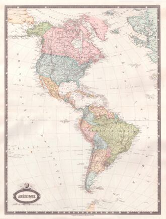
![]()
Interesting map of America with high detail and beautiful decorative colouring. The Panama Canal has not yet been built. Colombia is “Nouvelle Grenade” and Alaska is “Amerique Russe”. Much of the Amazon is labeled as “Selvas”, or tropical rainforests, and “Région Inconnue”. From Atlas Spheroidal et Universel de Geographie by M.F.A. Garnier published in Paris at Veuve Jules Renouard in 1862. This atlas is exceptional for its “spheroidal” maps of the globe, showing the various…
- Year: 1862
- Dimension: 680 x 510 mm
- Place of publication: Paris