Highlights
Showing all 10 results
-
![]()
[Brescia] Veduta di Brescia da Porta San Nazaro – Terra Antiqua, potens armis atque ubere glebe dedicata a Luigi Arici
More InfoLa più importante, ambita e rara veduta generale della città di Brescia
- Year: 1764
- Dimension: 1360 x 605 mm
- Place of publication: Brescia
-
![]() Out of stock
Out of stockQuesta rarissima carta geografica del territorio Bresciano è tratta dall’opera Italia geographice historiceque tabulis aeneis 37 delineata di Corrado Leone e pubblicata a Colonia nel 1598 con i tipi di Bertrami Buchholtz. L’interessante mappa appartiene alla cosiddetta Scuola Cartografica di Colonia che per circa mezzo secolo fu il centro più importante nella produzione geografica dovuta principalmente ai cartografi ed artisti fiamminghi ed olandesi che fuggivano dalle persecuzioni religiose. Gli esponenti maggiori furono Mattheus Quad, Giovanni Botero, Johannes Metellus e il fondatore Franz Hogenberg. Gli atlanti e le carte prodotte a Colonia in quel tempo venivano spesso pubblicate in forma anonima o con l’utilizzo di pseudonimi e quindi la loro genesi così come gli esatti dati editoriali risultano, a volte, piuttosto vaghi. Per quanto riguarda l’aspetto tecnico cartografico possiamo facilmente identificare il modello di riferimento nella medesima mappa del territorio Bresciano che Ortelius aveva pubblicato ad Anversa nel 1590 all’interno del celebre Theatrum Orbis Terrarum. Troviamo il classico orientamento a sinistra, lo stesso gusto rinascimentale del cartiglio con il titolo e tutti gli aspetti cartografici derivanti a loro volta dalla fondamentale grande mappa del Sorte. Manca il margine graduato con l’indicazione di latitudine e longitudine e i punti cardinali oriens, occidens e meridies sono inseriti entro il territorio. In basso è presente semplice scala grafica di 15 miglia Italiane.
- Year: 1598
- Dimension: 287 x 198 mm
- Place of publication: Colonia
-
![]() Out of stock
Out of stockBella e rara carta geografica della Toscana pubblicata da Matteo Florimi a Siena nel 1600 (firma in basso a destra) basata sulla mappa della medesima area disegnata da Girolamo Bellarmato e pubblicata da Claudio Duchetti a Roma nel 1558. Girolamo Bellarmato (Siena 1493 – 1560) fu matematico, ingegnere, architetto e cartografo e la sua carta corografica della Toscana fu il modello cartografico almeno per mezzo secolo. Oltre al Florimi, si ispirarono alla Tuscia del Bellarmato…
- Year: 1602 ca
- Dimension: 490 x 360 mm
- Place of publication: Siena
-
![]() Out of stock
Out of stockA spectacular and rare bird’s eye view of the city of L’Aquila. Title at upper centre, key in a cartouche surmounted by the arms of the dedicatee, Fernando de Casteo, Conde de Lemos, at left, arms of L’Aquila at upper right corner, royal arms of Spain, arms of the dedicator Blas Pico. Lauro was an acomplished Roman engraver. Amongst other works he is particularly known for his Antiquae urbis splendor, a four volume work dedicated … [cod.1064/15]
- Year: 1600
- Dimension: 515 x 385 mm
- Place of publication: Rome
-
![]()
prezzo a richiesta] Questa rarissima carta geografica del Bresciano appartiene alla cosiddetta Scuola Cartografica di Colonia che per circa mezzo secolo fu il centro pi importante nella produzione geografica dovuta principalmente ai cartografi ed artisti fiamminghi ed olandesi che fuggivano dalle persecuzioni religiose. Gli esponenti maggiori furono Mattheus Quad, Giovanni Botero, Johannes Metellus e il fondatore … [cod.996/15]
- Year: 1599
- Dimension: 500 x 375 mm
- Place of publication: Venice
-
![]() Out of stock
Out of stockLa vera et ultima discrettione dilla Lombardia et dal molti errori coreta in Venetia l’anno M.D.LXIIIII
More InfoRara e importante carta geografica della Lombardia pubblicata a Venezia come foglio sciolto da Ferrando Bertelli nel 1565. La mappa appartenente alla cosiddetta “scuola lafreriana” mostra in bel dettaglio la porzione di Italia settentrionale che si estende da Casale in Piemonte fino a Venezia e deriva dai modelli cartografici Gastaldiani ripresi precedentemente dal Luchini, dal Camocio e da Pietro de Nobili. Topograficamente, invece, riprende la carta in xilografia del 1520 intagliata da Luca Antonio de…
- :
- Year: 1565
- Dimension: 305 x 405 mm
- Place of publication: Venice
-
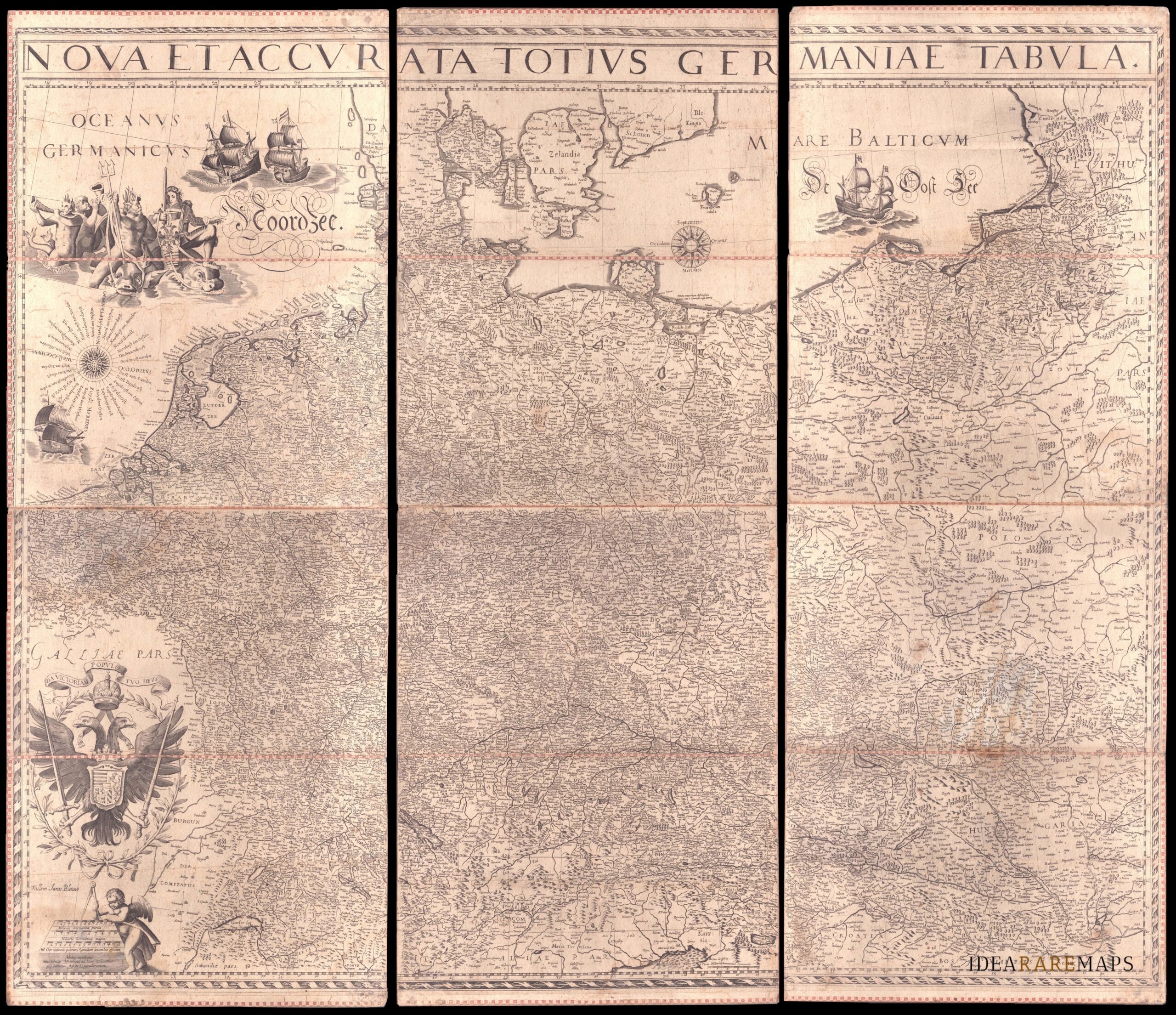
![]()
An exceptional wall map of the German Empire showing the Netherlands, Germany, Switzerland, Austria, Bohemia, Moravia, Poland and the Baltic Countries. Only three other copies are known to Schilder. Contemporary mounted on cardboard.
- Dimension: 108 x 125 cm
- Place of publication: Amsterdam
- Year: 1639
-
![]()
A rare and early separately issued plan of Pisa published by Matteo Florimi in 1603 circa . The plan covers the city in its entirety and showing on the left the Campo dei Miracoli with its famous Baptistry and leaning tower. Title in a strapwork surround surmounted by the arms of the Medici and Pisa, key in strapwork cartouche at upper left corner. Soli was a Sienese architectural draughtsman, painter, and engraver, who worked with…
- Year: 1603
- Dimension: 395 x 530 mm
- Place of publication: Siena
-
![]() Out of stock
Out of stockImportante e rara carta geografica che mostra la porzione di territorio nel nord Italia scenario delle battaglie combattute durante la guerra di successione spagnola da Eugenio di Savoia. La mappa è di grande interesse anche perchè documenta una produzione cartografica a Bologna ed è inoltre una rappresentazione originale non basata su prototipi o carte precedenti ma ottenuta da rilevamenti diretti sul campo: l’autore infatti inquadra nel suo disegno solo i territori effettivamente percorsi degli eserciti…
- Year: 1702
- Dimension: 461 x 690 mm
- Place of publication: Bologna
-
![]()
This Lafrery map is based on the Forlani view of Venice of 1566, and was engraved by G.Franco. Published by Giovanni Orlandi in Rome in 1602, the plate also bears the signature of C. Duchetti, the nephew and successor to Lafreri. Very Rare. Novacco, 144. [cod.1070/15]
- Year: 1602
- Dimension: 375 x 545 mm
- Place of publication: Rome