World
Showing 145–156 of 186 results
-
![]() Out of stock
Out of stockImportant map of South Pacific showing the tracks and discoveries made by Captain Cook, 1768-1771 and include the first circumnavigation of New Zealand and the mapping of the eastern coast of Australia. Noted are also Wallis’s discovery of Tahiti, Carteret’s discoveries of Pitcairn Island and his rediscovery of the Solomons which the Spaniard Mendana had sighted in 1568. The large decorative vignette in the lower right containing a number of plants, sea shells, a native…
- Dimension: 30 x 40 cm
- Place of publication: Venice
- Year: 1796
-
![]() Out of stock
Out of stockDetailed lovely map by Eduard Dumas-Vorzet showing Australia, New Zealand, and the island Pacific. From the famous Atlas Universel d’Histoire et de Geographie by Marie Nicolas Bouillet published in Paris in 1877.
- Year: 1877
- Place of publication: Paris
- Dimension: 260 x 200 mm
-
![]()
Map of Oceania and the Pacific Ocean region showing French, English, United States, Dutch, Japanese, Portuguese and Chilean possessions and colonies, depicted by colours. Shows shipping routes with distances between ports, capital cities and states. On verso a cover listing the publisher’s catalogue of the series. cfr: National Library of Australia, 6856870
- Dimension: 51 x 66 cm
- Place of publication: Paris
- Year: 1912
-
![]()
Lovely engraved map based on the cartography by C. Franz Radefeld (1788-1874) showing India, Tibet, China and Southeast Asia. From the “Meyer’s Neuester Zeitungs Atlas” published by Bibliographischen Instituts in Hildburghausen in 1849-52. The innovation of this work is that almost all maps had small inserts showing richly detailed maps of major cities and their surrunding areas: so not only could travellers carry the atlas with them easily, they could also obtain an initial orientation…
- Year: 1849
- Dimension: 265 x 210 mm
- Place of publication: Hildburghausen
-
![]()
Palestinae sive Totius Terrae Promissionis Nova Descriptio Auctore Tilemanno Stella Sigenens
More Info € 120,00Fascinating miniature version of Ortelius’ modern map of the Holy Land finely engraved by Philippe Galle. It shows the path of the Children of Israel through the wilderness and a few major cities. French text on verso.
- Year: 1598
- Dimension: 75 x 105 mm
- Place of publication: Antwerp
-
![]() Out of stock
Out of stockStriking route map of the World designed by John Philip, published in New York by Pan American Airlines, as a promotional item. Shows all the routes around the world to which Pan Am flew in 1959, including connecting lines and Pan Am’s own lines. Art by Casanova Associated. Pan American World Airways, commonly known as Pan Am, was the principal and largest international air carrier and unofficial overseas flag carrier of the United States from…
- Dimension: 44 x 80 cm
- Place of publication: New York
- Year: 1959
-
![]()
A fascinating and intriguing map of the world as a board game, featuring 142 numbered squares that start and end in Paris. The map is adorned with vignettes showing flora, fauna, people, and distinctive places from around the world. It is further enriched by vibrant illustrations depicting natural phenomena like the aurora borealis, charming landscapes, and exotic ocean liners and airplanes following their routes. The four corners symbolize Asia, Europe, America, and Africa. Clocks at…
- Dimension: 60 x 84 cm
- Place of publication: Paris
- Year: 1930
-
![]()
Paraguay o Prov. De Rio De La Plata cum regionibus adiacentibus Tucuman et Sta. Cruz De la Sierra
More Info € 140,00Early pocket map of the Rio de La Plata region in Uruguay showing also part of Argentina from the Mercator Hondius “Atlas Minor” published in Amsterdam in 1648 at Jannsonius with german text on verso. In 1607 Jodocus Hondius published a reduced size version of Mercator’s “Atlas”, itself suitably titled “Atlas Minor”. The maps were copied from those of the great cartographer Mercator of around 1580-90 or were reductions of Hondius’ own maps of 1606. Almost 20 years later Joannes Janssonius commi
- Year: 1648
- Dimension: 193 x 145 mm
- Place of publication: Amsterdam
-
![]()
Parte della Nuova Spagna o del Mexico dove sono le Provincie di Guadalaira Xabisco Mecoacan e Mexico
More Info € 500,00decorative map of western and central Mexico covers from Xiamora to Acapulco and includes Mexico City and Guadalajara along with cities, towns, mines, missions and Indian villages. Notations in the mountains north of Mexico City describe the rich deposits of silver and other annotations describe the manners and customs of the Indians. From Coronelli’s Atlante Veneto, one of the most decorative and ornate of all 17th Century Atlases, published in Venice, 1690. Vincenzo Maria Coronelli…
- Year: 1690
- Dimension: 453 x 605 mm
- Place of publication: Venice
-
![]()
Magnificent Coronelli’s map of the Indian Peninsula, from Guzarat to the Ganges. The map shows India below the Tropic of Cancer, with an insets of Ceylon and Trincomalee. It shows in very nice detail settlements, administrative division, larger towns, place names, rivers and canals. One of the most important and impressive large format 17th Century maps of the area. From the monumental Corso Geografico Universale published in Venice in 1690. Vincenzo Maria Coronelli is widely recognized as one of…
- Year: 1690
- Dimension: 454 x 605 mm
- Place of publication: Venice
-
![]() Out of stock
Out of stockAmazing pictorial map of the world’s international short wave radio stations, with each continent crammed with imagery. The map was drawn by Walter Eckhard (1903-1982) and published in Eindhoven, 1953 by the radio division of Philips. Superimposed on the map are red circles indicating the locations of dozens of shortwave radio stations. Small drawings throughout represent genre scenes depicting the people, plants and animals. Includes detailed index to the stations on the lower margin and…
- Dimension: 119 x 75 cm
- Place of publication: Eindhoven
- Year: 1953
-
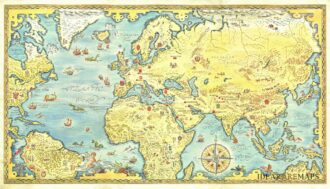
![]() Out of stock
Out of stockRare pictorial world map designed in the style of 17th century maps by the British painter and artist Gordon Davey (1912-1992) for Pakistan Airlines in 1960. The map is an interesting and curious mix between the classic geographical representations of the golden age of explorations (the wind rose, the numerous cartouches, sea monsters, galleons) and close modernity: in each country are depicted lovely little vignettes with ancient and modern reference: see for example the Roman…
- Dimension: 45,5 x 25,5 cm
- Year: 1960