20th Century
Showing 121–132 of 222 results
-
![]()
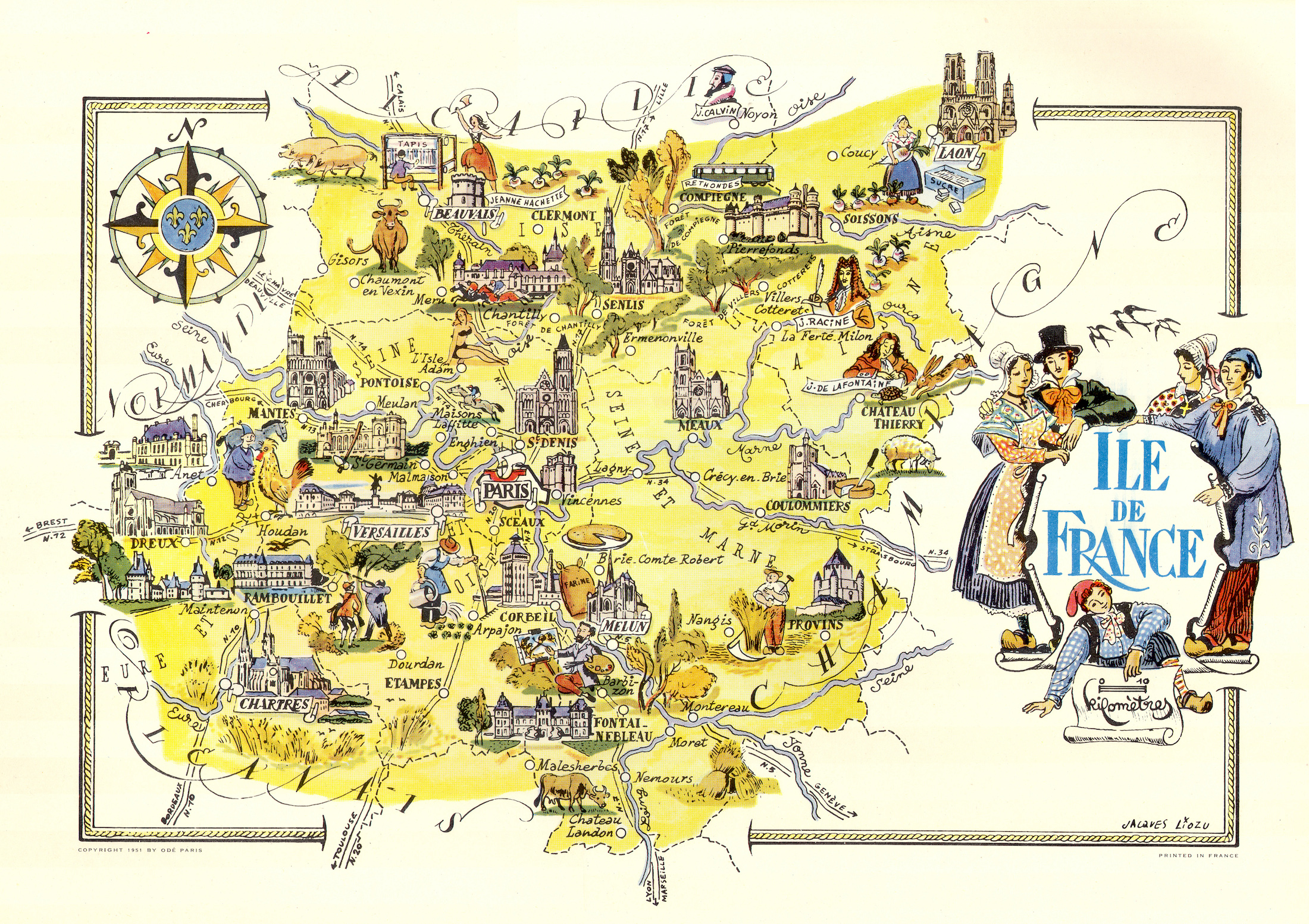
Color pictorial map of Ile de France and Paris covered with vignettes drawings of people and products of the province with explanation, representing region’s historical figures and events, resources, sights, churches, important buildings, people, activities, crops, etc. Includes decorative title cartouche and compass rose. Relief shown pictorially. Published by Ode Paris in 1951 from a drawn by Jaques Liozu.
- Dimension: 490 x 320 mm
- Place of publication: Paris
- Year: 1951
-
![]() Out of stock
Out of stockRara prima edizione del sontuoso ed elegantissimo atlante d’Italia compilato da Giovanni de Agostini corredato dall’interessante testo in due colori di G.Lang che descrive le regioni della penisola con la tipica enfasi e prosopopea caratteristica di quegli anni tumultuosi. Le 19 mappe sono opera dell’illustratore, pittore e scenografo russo naturalizzato italiano Vsevolod Petrovič Nikulin (Nicouline) il quale illustra i territori con un innovativo gusto geo-pittorico disegnando le città principali con il loro edificio più rappresentativo e arricchendo il tutto con personaggi in abiti tipici, punti di interesse così come le peculiarità agricole, commerciali, turistiche ed industriali delle varie aree. Tutte le carte presentano abbellimenti stilistici come grandi rose dei venti and indicare l’orientamento geografico, decorativi velieri nei mari e grandi cartigli con i titoli. L’apparato decorativo è infine completato dalla finitura dei bordi e di molti particolari con la stampa, a sottolineare l’importanza editoriale, di brillanti colori in oro e argento, uno dei primi esperimenti tipografici di questo tipo. Edito in 999 copie numerate questo nostro esemplare è il numero 127.
- Dimension: 47 x 31 cm
- Place of publication: Milan
- Year: 1941
-
![]() Out of stock
Out of stockRare propaganda broadside illustrating the Italian East Africa.
- Dimension: 42 x 66 cm
- Place of publication: Milan
- Year: 1936
-
![]() Out of stock
Out of stockA lovely and uncommon map of Southeast Asia showing the French Indochina published in Paris by the pharmaceutical laboratories Neutroses-Vichy in 1939 at Petit Jean. Laos, Cambodia and Vietnam are symbolized by small vignette.
- Dimension: 310 x 210 mm
- Place of publication: Paris
- Year: 1939
-
![]() Out of stock
Out of stockSeparately issue version of Federico De Agostini stunning map of Italy, first published in 1946 by Italgeo here in the Arti Grafiche Ricordi edition published in Milan, 1978. The illustrator of the pictorial map is Vsevolod Petrovic Nicouline: it shows vignettes of structures, nature, activities, products, crops and many towns and cities labeled. Embellished by elegant calligraphy, compass rose and a Neptune in the sea.
Vsevolod Petrovic Nicouline (1890-1962) was a renowned Russian painter, printmaker, ceramicist, designer and illustrator born in the Ukraine in 1890. For a time he was with the Imperial Academy of Petersburg. His teaching career there was interrupted by the Bolshevik revolution. He was forced to flee and, after a daring journey, arrived in Constantinople accompanied by the Countess Bossalinie Aida who later became his wife. They survived in this city with menial jobs, and were finally able to join relatives in Genoa in 1920 where he held his first exhibition. In 1922 he moved to Nervi, opening a studio at the first Polish residence, meeting other Russian and Polish exiles. His years were rich in relationships, artists, and writers for whom he designed several books and arranged illustrations, commissions of portraits and more. In 1941 he was inaugurated into the Teatro Carlo Felice and designed sets for La Scala and the Metropolitan New York. He was an important illustrator of more than 100 children’s books.- Dimension: 80 x 64 cm.
- Place of publication: Milan
- Year: 1978
-
![]() Out of stock
Out of stockSeparately issue version of Federico De Agostini stunning map of Italy, first published in 1946 by Italgeo. Published in Milan as ad for Motta, 1960. The illustrator of the pictorial map is Vsevolod Petrovic Nicouline: it shows vignettes of structures, nature, activities, products, crops and many towns and cities labeled. Embellished by elegant calligraphy, compass rose and a Neptune in the sea.
Vsevolod Petrovic Nicouline (1890-1962) was a renowned Russian painter, printmaker, ceramicist, designer and illustrator born in the Ukraine in 1890. For a time he was with the Imperial Academy of Petersburg. His teaching career there was interrupted by the Bolshevik revolution. He was forced to flee and, after a daring journey, arrived in Constantinople accompanied by the Countess Bossalinie Aida who later became his wife. They survived in this city with menial jobs, and were finally able to join relatives in Genoa in 1920 where he held his first exhibition. In 1922 he moved to Nervi, opening a studio at the first Polish residence, meeting other Russian and Polish exiles. His years were rich in relationships, artists, and writers for whom he designed several books and arranged illustrations, commissions of portraits and more. In 1941 he was inaugurated into the Teatro Carlo Felice and designed sets for La Scala and the Metropolitan New York. He was an important illustrator of more than 100 children’s books.- Dimension: 80 x 64 cm.
- Place of publication: Milan
- Year: 1960
-
![]() Out of stock
Out of stockSeparately issued version of Federico De Agostini’s stunning map of Italy, first published in 1946 by Italgeo here in the Arti Grafiche Ricordi edition published in Milan, 1989. The illustrator of the pictorial map is Vsevolod Petrovic Nicouline: it shows vignettes of structures, nature, activities, products, crops and many towns and cities labelled. Embellished by elegant calligraphy, compass rose and a Neptune in the sea. Vsevolod Petrovic Nicouline (1890-1962) was a renowned Russian painter, printmaker,…
- Dimension: 80 x 64 cm.
- Place of publication: Milan
- Year: 1989
-
![]()
Non comune bella guida in francese edita dal Vespa club d’Italia per promuovere i viaggi nel Bel Paese e scoprirne le bellezze in Vespa. La divertente guida è corredata da 14 carte geografiche pittoriche disegnate dall’illustratore Nicouline che mostrano le regioni italiane con le loro peculiarità e luoghi da visitare. Le carte sono completate dalle tabelle con l’indicazione delle salite e le altitudini da raggiungere nei vari itinerari. Il testo prevede anche i luoghi tipici per le soste, i rifornimenti, le officine specializzate e i cartelli per una guida sicura in Italia.
- Dimension: 21,5 x 12 cm
- Place of publication: Milan
- Year: 1957
-
![]() Out of stock
Out of stockA clever preprinted envelope for use by Japanese Imperial military, listing and illustrating the battles and victories of the Imperial forces. A remarkable envelope in that as it is unfolded two sticks pop up with a string strung between them. Little paper flags hang from the string including those of Fascist Italy, Imperial Japan, Nazi Germany, and Vichy France. The background is a map of the world with vignettes of battle scenes including two mobile…
- Dimension: 23 x 48 cm
- Place of publication: Tokyo
- Year: 1943
-
![pictorial map italy]() Out of stock
Out of stockA wonderful and rare poster promoting tourism in Italy, showing the peninsula as a perspective view and with very interesting annotations highlighting the moments, the productive activities, the new resources, the social and economic changes that allowed Italy to recover after the Second World War. Designed by Arti Grafiche Menaglia and published in Rome in 1956 by the Ministry of Foreign Affairs for the Italian Embassy in the United States based in New York.
- Dimension: 100 x 70 cm.
- Place of publication: Rome
- Year: 1956
-
![]()
A beautiful guide in 48 pages to the gastronomic delights of Germany richly illustrated by Herman Schneider. Published in Berlin in 1953. In the end, folded, a fine pictorial map of Germany.
- Dimension: 58 x 40 cm
- Place of publication: Berlin
- Year: 1953
-
![]() Out of stock
Out of stockItalian 1916 edition of the propaganda world map showing the British Empire at war published by Roberts & Leete. The map is surrounded by illustrations and figures showing the increase in the size of the British Army and Navy between 1914 and 1916, contributions of the “Overseas Army,” changes in the “Industrial Army” and the “War of Munitions” and the approximate amount of territory occupied by the Central Powers and the Allies on August 2nd,…
- Dimension: 38 x 51 cm
- Place of publication: London
- Year: 1916