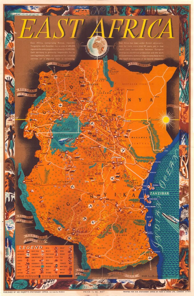
Bellissima e rara mappa pittorica disegnata nel 1947 dall’artista Neozelandese Leo Vernon Bensemann (firma in basso a destra) che mostra l’Africa orientale con gli attuali territori di Kenya, Tanzania, Zanzibar e Uganda. Arricchita da una decorativa cornice con animali, nativi, scorci tipici e completata in alto, sotto il grande titolo, da una breve descrizione geografica e dalla piccola rappresentazione del globo terrestre centrato sul continente africano. La carta che si estende dal lago Tanganica all’Oceano Indiano e dal confine tra Sudan ed Etiopia al fiume Ruvuma aveva lo scopo di promuovere il turismo in Africa orientale sottolineandone la flora esotica, gli innumerevoli e affascinanti animali selvatici e la facilità di spostamento grazie a una completa rete di trasporto stradale, ferroviario e aereo. In basso a sinistra una legenda elenca i prodotti agricoli coltivati e i simboli per identificare sulla mappa tribù, riserve di caccia, insediamenti, strade principali e campi di atterraggio per aerei. Pubblicata a Londra da Fosh & Cross Ltd. nel 1948.
Related products
-
Out of stock
Large poster map showing the origin (highlighted in shiny silver) of the ingredients for the production of Astra’s margarine. Palm and peanut oil from French West and Equatorial Africa. The coconut oil from Polynesia. Published in Paris at Courbet 1955.
- Author: Atelier Coubert
- Dimension: 120 x 80 cm
- Place of publication: Paris
- Year: 1955
-
Out of stock
A large pictorial map by J. Choain Audiberti of French Equatorial Africa showing several African countries including Nigeria, Chad, Cameroon, Gabon, Central African Republic and the Belgian Congo. The map is illustrated with lovely vignettes of people, farming, trees, mountains and animals like tigers, camels, horses, antelopes, ostriches, giraffes, elephants. It is completed by ships at sea, cars driving through the desert, planes flying over the map; at bottom a fine cartouche with a traditional African village scene surrounding the larger map of Africa. Published in Paris, 1950
- Author: J. Choain Audiberti
- Dimension: 120 x 80 cm
- Place of publication: Paris
- Year: 1950
-
Out of stock
A colourful promotional map of French West Africa by Leon Craste designed to promote tourism and commercial development in French West Africa, which continued to operate as a political federation until 1960. Published by French Ministry of Overseas in 1951. The map shows the area from Atlantic Ocean to Chad and Cameroon and from Algeria to Togo including the colonies of Mauritania, Sudan, Senegal and Ivory Coast and some of the Portuguese territories like Guinea-Bissau, Gambia, Ghana and Nigeria. Illustrations of major cities, agricultural products, natural resources and exotic animals are on display, along with an inset showing French possessions relative to the entire continent.
- Author: Leon Craste
- Dimension: 120 x 80 cm
- Place of publication: Paris
- Year: 1951
-
Out of stock
colourful large promotional map by Leon Craste designed to promote tourism and commercial development in Cameroon. Published by French Ministry of Overseas in 1950 at Imprimerie A. Karcher. The map shows the area from French West Africa (A.O.F.) and Nigeria to French East Africa and from Lake Chad to Gabon and Spanish Guinea; it is richly decorated by lovely illustrations of African animals (elephants, rhinos, lions, hippos, giraffes etc.) and a native people going about…
- Author: Leon Craste
- Dimension: 120 x 80 cm
- Place of publication: Paris
- Year: 1950


