London
Showing 1–12 of 13 results
-
![]() Out of stock
Out of stockRelief map by S.J. Turner representing a bird’s eye view from space encompassing a wide swath of the globe from Italian Somaliland at the lower edge to Morocco and Italy at the upper edge of the map. Shows the political divisions in the Horn of Africa during Italy’s conquest of the region, railways. major cities, and rivers. Includes European possession in Africa. Published in London, 1938 for Daily Herald.
- Dimension: 69 x 47 cm
- Place of publication: London
- Year: 1938
-
![]()
[Poland] Poland, Shewing the Claims of Austria, Russia, Prussia & Austria from the best Authorities
More Info € 180,00Uncommon map of Poland and Lithuania by G. Kearsley engraved by James Barlow showing the second of three partitions of the area that ended the existence of the Polish–Lithuanian Commonwealth. The second partition occurred in the aftermath of the Polish–Russian War of 1792 and the Targowica Confederation of 1792, and was approved by its territorial beneficiaries, the Russian Empire and the Kingdom of Prussia. The very interesting map was published in London in 1807.
- Dimension: 18 x 21,5 cm
- Place of publication: London
- Year: 1807
-
![]() Out of stock
Out of stockAn uncommon pictorial map of The British Isles designed by Cecil Meyer showing the railway system with the major cities symbolized by the most important buildings, usually a church or lordly manor. Bordered by coats of arms from the cities of the British Isles and with decorative cartouche for Scotland, England, Ireland and Wales, plus a decorative compass rose. On verso: Ten panels, showing landmarks, with brief explanatory text and coat of arms, and text…
- Dimension: 57 x 45 cm
- Place of publication: London
- Year: 1935
-
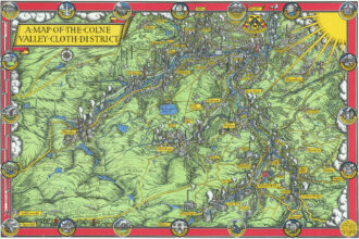
![]() Out of stock
Out of stockFine 1947 pictorial map by MacDonald Gill showing the Colne Valley Cloth District in Yorkshire, England.
- Dimension: 33 x 49 cm
- Place of publication: London
- Year: 1947
-
![]() Out of stock
Out of stockFascinating pictorial map of Sierra Leone showing through delightful vignettes the typical products and industries of the West African state at the time of British colonialism. At the top, two panels with imports and exports while the lower part is dominated by the legend with conventional signs, types of industries and a graphic list of vignettes with agricultural products. The map is undated but the right margin lists the most important historical events for the…
- Dimension: 50 x 38 cm
- Place of publication: London
- Year: 1925
-
![]() Out of stock
Out of stockAn appealing 1800 map or city plan of Naples, issued by John Stockdale. The map is very detailed, noting walls, forts, bridges, gates, roads and a host of additional topographical features. In the sea a compass rose and a panel listing 80 point of interest. At bottom left a nice baroque title cartouche with lovely vignette. At topo, out of margin, the King’s Castle.
From J. Stockdale’s “A geographical, historical and political description of the empire of Germany, Holland, the Netherlands, Switzerland, Prussia, Italy, Sicily, Corsica, and Sardinia” Published in London, 1800.- Dimension: 20 x 26 cm
- Place of publication: London
- Year: 1800
-
![]()
Uncommon map of Africa by G. Kearsley engraved by James Barlow published in London in 1807.
- Dimension: 18 x 21,5 cm
- Place of publication: London
- Year: 1807
-
![]()
Decorative large pictorial system map of Europe and Northern Africa signed Hawes, showing BEA and affiliate routes (Aer Lingus, Alitalia, Cyprus Airways, Gibraltar Airways, and The Malta Airlines). Illustrated with figures representing regional dress; animals and fish; landmarks; mountain ranges; roads; railways; and major cities. The map is embellished by BEA airliner depicted over the Mediterranean Sea and compass rose with the Coat of Arms. Published in London, 1953 by George Philip & Son, Ltd. British…
- Dimension: 85 x 109 cm
- Place of publication: London
- Year: 1953
-
![]() Out of stock
Out of stockBellissima e rara mappa pittorica disegnata nel 1947 dall’artista Neozelandese Leo Vernon Bensemann (firma in basso a destra) che mostra l’Africa orientale con gli attuali territori di Kenya, Tanzania, Zanzibar e Uganda. Arricchita da una decorativa cornice con animali, nativi, scorci tipici e completata in alto, sotto il grande titolo, da una breve descrizione geografica e dalla piccola rappresentazione del globo terrestre centrato sul continente africano. La carta che si estende dal lago Tanganica all’Oceano…
- Dimension: 48 x 72 cm
- Place of publication: London
- Year: 1948
-
![]()
Very handsome chart of the Bay of Biscay with the north coast of Spain from Cap Finisterre, and west coast of France north to Brest. Locates Bayone, Bordeaux, Nantes, etc. with information on soundings and anchorages. From Hydrographie Francaise.
- Year: 1797
- Dimension: 855 x 543 mm
- Place of publication: London
-
![]()
A fine map of North America with a lovely detailed depiction of the East Coast. A large lake is shown in present day Idaho. The interesting map was engraved with great care by James Barlow. Published in London in 1807.
- Dimension: 18 x 21,5 cm
- Place of publication: London
- Year: 1807
-
![pictorial map antarctica]() Out of stock
Out of stockInteresting folding map of Antarctica, one of the most decorative maps published as part of the celebration of the International Geophysical Year (July 1957-December 1958). It shows the whole continent with the natural features drawn in blue and the international bases drawn in red. The decorative pictorial border shows key explorers such as Amundsen, Scott and Shackleton, fundamental equipment for exploration, some of the ships used by various explorers and animals found in and around…
- Dimension: 72 x 47 cm
- Place of publication: London