Germany
Showing 13–24 of 28 results
-
![]()
A beautiful guide in 48 pages to the gastronomic delights of Germany richly illustrated by Herman Schneider. Published in Berlin in 1953. In the end, folded, a fine pictorial map of Germany.
- Dimension: 58 x 40 cm
- Place of publication: Berlin
- Year: 1953
-
![]()
A beautiful colored pictorial map with inset map of Europe showing location of Nazi Germany, promoting tourism. Showing major cities, historical people and places of interest, agriculture, industry, sports, Berlin and 1936 Olympic Games. On verso map of Germany showing roads and railways, inset map of air routes, and text and tourist information. Drawn by Riemer and published in Berlin by Reichsbahnzentrale fur den Deutschen Reiseverkehr in 1941.
- Dimension: 77 x 57 cm
- Place of publication: Berlin
- Year: 1941
-
![]() Out of stock
Out of stockVery rich and detailed brochure with pictorial map of the Rhineland. The cartoon map by Leo Faller provides a striking overview of whole Rhine valley and it extends from Kleve and Emmerich to Pforzheim. On verso text in English. An attractive and uncommon ephemeral item in excellent condition.
- Dimension: 40,5 x 77,5 cm
- Place of publication: Dusseldorf
- Year: 1951
-
![]()
A nice example of Gerard De Jode highly detailed map of Saxony centered on Mansfeld. From the rare Speculum Orbis Terrae published in Amsterdam in 1593 by Cornelis De Jode.
- Year: 1593
- Dimension: 334 x 250 mm
- Place of publication: Antwerp
-
![Germany Vintage Pictorial map]() Out of stock
Out of stockColor pictorial map, with decorative border and title cartouche over compass rose. Shows vignettes of landmarks and buildings, vessels and steam boats, rivers and mountains. Includes inset 8 vignettes showing allegories of science, transport, aeronautics, technics, art, architecture, sport and music. Published by Reichsbahnzentrale fur den Deutschen Reisenverkher in Berlin at Erasmusdruck, 1930.
- Dimension: 58 x 42 cm
- Place of publication: Berlin
- Year: 1930
-
![]()
A lovely original antique miniature map of Brandenburg in Germany.
From the uncommon Neu aussgeffertigter kleiner Atlas by J. U. Muller published in Franckfurt in 1692 at Johann Philip Andrea.
The map was engraved with great care by G. Karsch e G. Bodeneher.
See G. King Miniature antique maps (1st edition) pag.136- Dimension: 70 x 80 mm
- Place of publication: Frankfurt
- Year: 1702
-
![]()
Neue und vollständige Postkarte durch ganz Deutschland – Nouvelle Carte geographique des Postes D’Allemagne
More Info € 400,00Very interesting engraved map compiled by Johann Jakob von Bors and Franz J. Heger, dissected and mounted on linen, showing the mail routes with distances measured in hours on horseback and hours with the stagecoach. The large map extending west to east from Paris to Cracau and north to south from Königsberg to upper Italy with the nice depiction of the important road from Venice to Turin via Milan, Bergamo and Brescia. Very decorative allegorical cartouches and lower left portions of map, key in French and German. Original colors in outline. In nice condition to be a separate publishing used in traveling. Published at Homann Heir in 1764 (dated). First Edition.
- Dimension: 75 x 95 cm
- Place of publication: Nuremberg
- Year: 1786
-
![]()
Important early woodblock map by Sebastian Munster showing the Black Forest the large forested mountain range in the state of Baden-Württemberg in southwest Germany. From the rare “Geographia Universalis, Vetus et Nova, complectens Claidii Prolemaei Alexandrini enarrationis libros VIII” published in Basel at Heinrich Petri in 1552.
- Year: 1552
- Dimension: 285 x 375 mm
- Place of publication: Basle
-
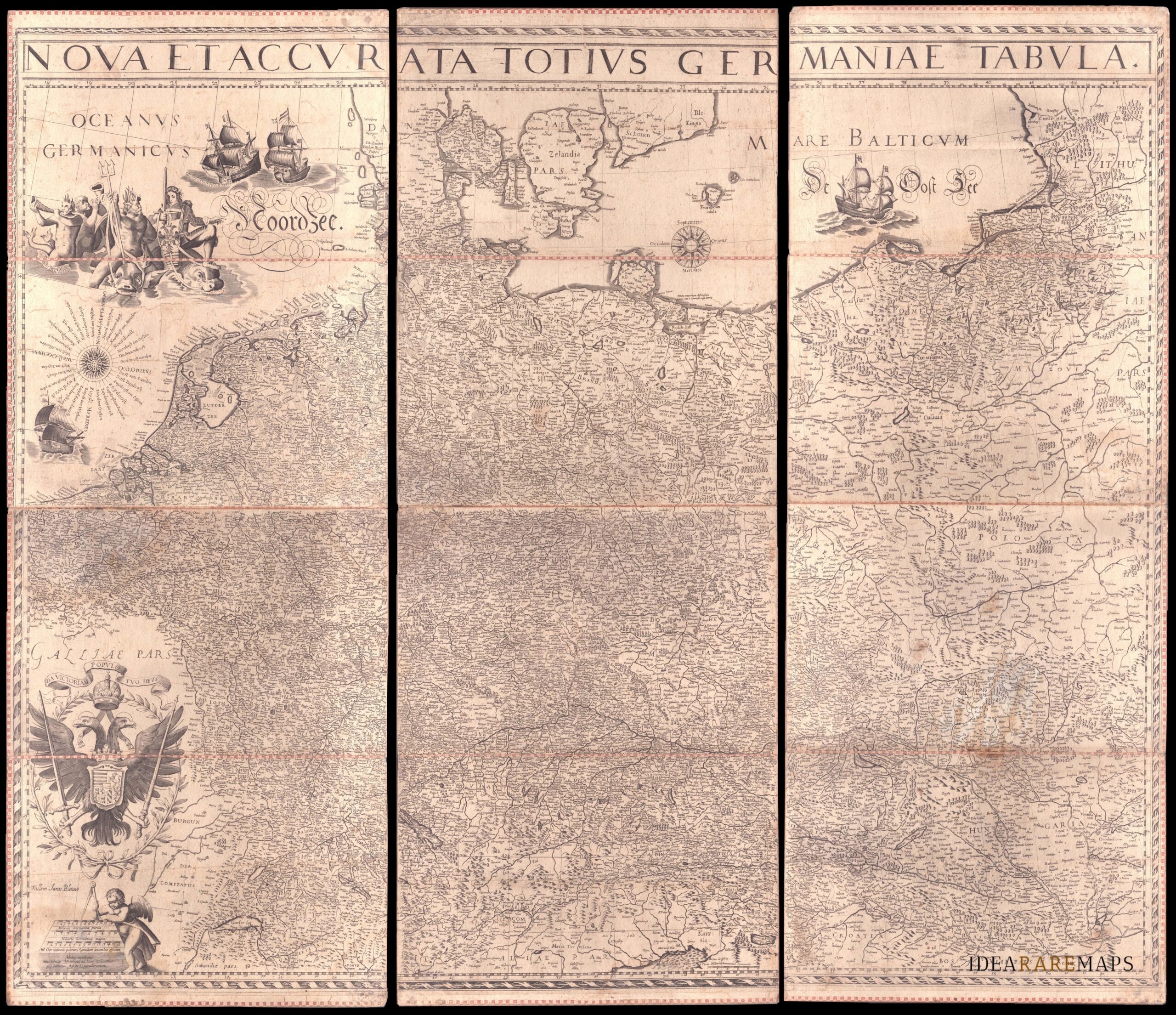
![]()
An exceptional wall map of the German Empire showing the Netherlands, Germany, Switzerland, Austria, Bohemia, Moravia, Poland and the Baltic Countries. Only three other copies are known to Schilder. Contemporary mounted on cardboard.
- Dimension: 108 x 125 cm
- Place of publication: Amsterdam
- Year: 1639
-
![]()
Very detailed and decorative map in two sheets of Cologne showing in great care the course of Rhine from Coronelli’s Corso Geografico Universale published in Venice in 1690. Vincenzo Maria Coronelli is widely recognised as one of Italy?s most famous and greatest cartographers. He received an ecclesiastical education at the convent of the Minor Conventuals and also studied theology in Rome. However, his interests in geography and cartography were awoken early in his ecclesiastical career and neve
- Year: 1690
- Dimension: 450 x 610 mm each
- Place of publication: Venice
-
![]()
A most decorative map of Prussia. It replaced the older map (v.d.Broecke, map 156) in the editions from 1595 on. It is based on the large woodcut map of Prussia by Caspar Henneberg of 1576. Van den Broecke: 157
- Year: 1603
- Dimension: 367 x 468 mm
- Place of publication: Antwerp
-
![pictorial map germany]() Out of stock
Out of stockPictorial map of Germany issued in 1964 by Deutsche Zentrale für Fremdenverkehr
- Dimension: 55 x 35 cm
- Place of publication: Kempen
- Year: 1964