Detailed topographical map of Berlin published in 1962, very shortly after the construction of the Berlin wall which isolated the west part from the east until 1989, by the Presse- und Informationsamt des Landes.
The powerful map is interesting also because it is before the construction of the second wall beginning in June 1963, which established the so-called death strip.
At top large title and the the coat of arms of Berlin west (a black bear on a white shield) introduced in 1954. At right side symbols and description about transportation and at bottom explanation of the the check points, borders and borderline areas.
The west Berlin is surrounded with a barb wire. On verso photographic images and statistic charts showing the development of economy and numbers of refugees until 1960. Folds as issued.

Berlin
Detailed topographical map of Berlin published in 1962, very shortly after the construction of the Berlin wall which isolated the west part from the east until 1989, by the Presse- und Informationsamt des Landes.
The powerful map is interesting also because it is before the construction of the second wall beginning in June 1963, which established the so-called death strip.
At top large title and the the coat of arms of Berlin west (a black bear on a white shield) introduced in 1954.
- Dimension: 60 x 83 cm
- Place of publication: Berlin
- Year: 1962
Related products
-
![pictorial map germany]() Out of stock
Out of stockPictorial map of Germany issued in 1964 by Deutsche Zentrale für Fremdenverkehr
- Dimension: 55 x 35 cm
- Place of publication: Kempen
- Year: 1964
-
![]()
Very rare map engraved by Elias Baeck from ?Der curiose und .. Nssliche Dollmetscher..? published in Augsburg in 1748. The map has decorative cartouche and a nice original colouring. Missing in many reference.
- Year: 1748
- Dimension: 225 x 165 mm
- Place of publication: Augsburg
-
![]() Out of stock
Out of stockA rare very detailed cartoon map of Frankfurt am Main published in Darmstadt in 1954 by Stars UY Stripes. All the historic sites, streets and famous buildings are labeled and many of them are illustrated by lovely vignettes or caricatures (see Beethoven, Goethe, Stolze, Adickes and others). The funny map drawn by Byrel W. Burgess shows also all the Frankfurt greater area with a particular attention to the American presence (schools, hospitals, posts etc.). Chicago it’s curiously drawn in top right corner.
- Dimension: 59,5 x 89 cm
- Place of publication: Darmstadt
- Year: 1954
-
![]()
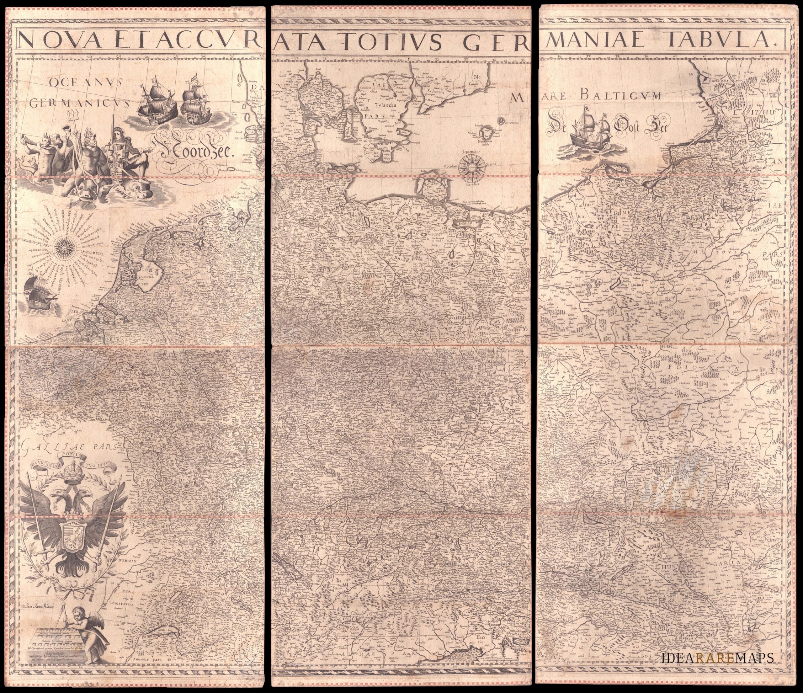
An exceptional wall map of the German Empire showing the Netherlands, Germany, Switzerland, Austria, Bohemia, Moravia, Poland and the Baltic Countries. Only three other copies are known to Schilder. Contemporary mounted on cardboard.
- Dimension: 108 x 125 cm
- Place of publication: Amsterdam
- Year: 1639