Bella carta pittorica della Germania dell’Ovest disegnata da Heinz e Suse Thate che, come spesso succedeva nelle rappresentazioni del tempo, mostrava anche la porzione orientale (senza menzionare la DDR) e un piccolo inserto con i confini della Germania al 1937 compresi i territori che furono annessi alla Polonia e all’Unione Sovietica dopo la guerra. Commissionata dal Deutsche Zentrale für Fremdenverkehr di Francoforte per promuovere il turismo e pubblicata nel 1964 presso l’editore teNeues di Kempen.
Out of stock

Romantisches Deutschland
Pictorial map of Germany issued in 1964 by Deutsche Zentrale für Fremdenverkehr
- Dimension: 55 x 35 cm
- Place of publication: Kempen
- Year: 1964
Related products
-
![]()
Very detailed and decorative map in two sheets of Cologne showing in great care the course of Rhine from Coronelli’s Corso Geografico Universale published in Venice in 1690. Vincenzo Maria Coronelli is widely recognised as one of Italy?s most famous and greatest cartographers. He received an ecclesiastical education at the convent of the Minor Conventuals and also studied theology in Rome. However, his interests in geography and cartography were awoken early in his ecclesiastical career and neve
- Year: 1690
- Dimension: 450 x 610 mm each
- Place of publication: Venice
-
![]()
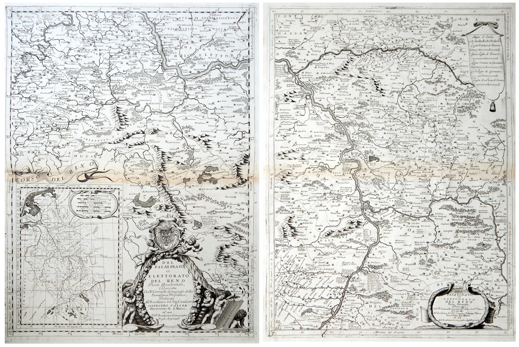
Del Palatinato et Elettorato del Reno parte Occidentale… / Del Palatinato et Elettorato del Reno parte Orientale
More Info € 600,00Very detailed and decorative map in two sheets of Rhine Valley from Coronelli’s Corso Geografico Universale published in Venice in 1690. Inset map of the entire River. Vincenzo Maria Coronelli is widely recognised as one of Italy?s most famous and greatest cartographers. He received an ecclesiastical education at the convent of the Minor Conventuals and also studied theology in Rome. However, his interests in geography and cartography were awoken early in his ecclesiastical career and never supp
- Year: 1690
- Dimension: 605 x 450 mm each
- Place of publication: Venice
-
![]()
Detailed topographical map of Berlin published in 1962, very shortly after the construction of the Berlin wall which isolated the west part from the east until 1989, by the Presse- und Informationsamt des Landes.
The powerful map is interesting also because it is before the construction of the second wall beginning in June 1963, which established the so-called death strip.
At top large title and the the coat of arms of Berlin west (a black bear on a white shield) introduced in 1954.- Dimension: 60 x 83 cm
- Place of publication: Berlin
- Year: 1962
-
![]()
Very rare map engraved by Elias Baeck from ?Der curiose und .. Nssliche Dollmetscher..? published in Augsburg in 1748. The map has decorative cartouche and a nice original colouring. Missing in many reference.
- Year: 1748
- Dimension: 225 x 165 mm
- Place of publication: Augsburg