A rare and early separately issued plan of Messina published by Matteo Florimi in Siena, 1600 circa. The plan covers the city in its entirety and showing at bottom the coast of Calabria with the city of Reggio on the left. Embellished by rare original colours and many vessels in the sea and harbour. Below a key listing 167 points of interest.

Related products
-
![]()
Very rare aquatint view from “Voyage pittoresque en Sicile” by Gicault de la Salle published in Paris in 1822.
- Year: 1822
- Dimension: 295 x 425 mm
- Place of publication: Paris
-
![antique map palermo sicily]() Out of stock
Out of stockElegante pianta topografica di Palermo disegnata da E. Sanzo e pubblicata dall’editore Remo Sandron in occasione della “IV Esposizione Nazionale Italiana”. In alto a sinistra, sotto lo stemma della città e il titolo, una piccola veduta dell’esposizione tenuta nei pressi di via Principe di Villafranca ed evidenziata in pianta dal colore verde. La bella e grande rappresentazione, stampata in litografia a quattro colori, è completata ai lati da una ricchissima legenda con tutti i punti…
- Dimension: 47 x 67 cm
- Place of publication: Palermo
- Year: 1892
-
![antica carta sicilia]() Out of stock
Out of stockAn uncommon map of Sicily based on the map of the Royal Topographical Office of Naples published in 1826. The map, published as a loose sheet, is not dated, but it is probably one of the many representations of the island published around 1860 to meet the demands of a market attentive to the political and military events of that period. In April 1860 the revolt of the city of Palermo against the Bourbons of…
- Dimension: 65 x 50 cm
- Place of publication: Turin
- Year: 1860
-
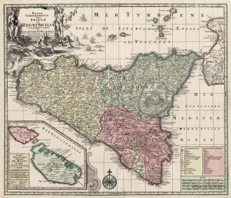
![antica mappa sicilia malta]() Out of stock
Out of stockA stunning map of Sicily published by M. Seutter in 1730. Inset at bottom a nice map of Malta and Gozo. Showing also the Etna erupting.
- Year: 1730
- Dimension: 580 x 500 mm
- Place of publication: Augsburg