world maps
Showing 25–36 of 37 results
-
![]()
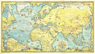
A fascinating and intriguing map of the world as a board game, featuring 142 numbered squares that start and end in Paris. The map is adorned with vignettes showing flora, fauna, people, and distinctive places from around the world. It is further enriched by vibrant illustrations depicting natural phenomena like the aurora borealis, charming landscapes, and exotic ocean liners and airplanes following their routes. The four corners symbolize Asia, Europe, America, and Africa. Clocks at…
- Dimension: 60 x 84 cm
- Place of publication: Paris
- Year: 1930
-
![]() Out of stock
Out of stockAmazing pictorial map of the world’s international short wave radio stations, with each continent crammed with imagery. The map was drawn by Walter Eckhard (1903-1982) and published in Eindhoven, 1953 by the radio division of Philips. Superimposed on the map are red circles indicating the locations of dozens of shortwave radio stations. Small drawings throughout represent genre scenes depicting the people, plants and animals. Includes detailed index to the stations on the lower margin and…
- Dimension: 119 x 75 cm
- Place of publication: Eindhoven
- Year: 1953
-
![]() Out of stock
Out of stockRare pictorial world map designed in the style of 17th century maps by the British painter and artist Gordon Davey (1912-1992) for Pakistan Airlines in 1960. The map is an interesting and curious mix between the classic geographical representations of the golden age of explorations (the wind rose, the numerous cartouches, sea monsters, galleons) and close modernity: in each country are depicted lovely little vignettes with ancient and modern reference: see for example the Roman…
- Dimension: 45,5 x 25,5 cm
- Year: 1960
-
![]() Out of stock
Out of stockOne of the most decorative eighteenth century world maps. This J.B. Homann’s double hemisphere map of the world is richly embellished with celestial models of the northern and southern hemispheres and other natural phenomena such as waterspouts, a rainbow, earthquakes, and the Mt. Etna in Sicily erupting. Wind heads occupy the starry heavens, and two cherubs hold the title banner aloft. The map includes many famous cartographic inaccuracies with an unusually elongated northwest coastline in North America, labeled Terra Esonis. It also shows an incomplete Australia, although with place names and notes of the early discoverers included. The east coast of New Zealand is shown, along with the Tracts of Tasman’s 1642 voyage and Magellan’s Voyage. The detail in Southeast Asia is very interesting for the period, as is the treatment of Japan. Interesting text panels at bottom describe the natural phenomena.
- Dimension: 48,5 x 55 cm
- Place of publication: Nuremberg
- Year: 1720
-
![]()
Portugal – The country that has contributed most to Geographic Knowledge of the Globe.
More Info € 450,00Portolan-style world map printed in red, green, blue, and gold, showing the voyage tracks of over twenty sixteenth-and-seventeenth-century Portuguese explorers. Less than 10 institutional examples located.
- Dimension: 43 x 63 cm
- Place of publication: Porto
- Year: 1940
-
![]() Out of stock
Out of stockA lovely vintage poster designed by Otto Nielsen for SAS Scandinavian Airlines System showing the World in beautiful bright colors on dark background. The map is embellished by fine vignettes and the destinations where the SAS operates in elegant gold. Scandinavian Airlines System is the flag carrier of Sweden, Norway, and Denmark, founded in 1946. SAS is the eighth largest airline in Europe and operates 157 aircraft to 123 destinations.
- Dimension: 45 x 75 cm
- Place of publication: Copenhagen
- Year: 1950
-
![]()
Fascinating chart showing the celestial hemispheres in the Autumn and Spring skies, plus smaller North and South polar projections and the orbits of the Planets with the with the non-existent planet Vulcan orbiting Mercury.
- Dimension: 52 x 74 cm
- Place of publication: Paris
- Year: 1862
-
![]()
Uncommon brochure with a reduced version of the famous and decorative double hemisphere pictorial map prepared by Luc-Marie Bayle for TAI Transport Aeriens Intercontinentaux. The depliant shows all the routes of the company.
TAI routes are shown in red. The Transport Aeriens Intercontinentaux company began as a charter airline in June 1946 in association with the Messageries Maritime Shipping Company.- Dimension: 41 x 24 cm
- Place of publication: Paris
-
![]() Out of stock
Out of stockFirst edition of the decorative double hemisphere pictorial map prepared by Luc-Marie Bayle for TAI Transport Aeriens Intercontinentaux with two decorative compass rose oriented with the north to the upper margin. The hemispheres are surrounded by fun images of various explorers in divers modes of transport a hot air balloon, early and later forms of aeroplanes, rowing boats, sailing ships, galleons, whales and fish. TAI routes are shown in red. The Transport Aeriens Intercontinentaux company began as a charter airline in June 1946 in association with the Messageries Maritime Shipping Company.
- Dimension: 51 x 73 cm
- Place of publication: Paris
- Year: 1948
-
![]() Out of stock
Out of stockBellissima carta del mondo così come era conosciuto al tempo dell’esploratore Giovanni Caboto disegnata dal celebre artista inglese MacDonald Gill nel 1924 (firma in basso a sinistra). La carta è inserita nel volume Pageant of British Empire, Souvenir Volume… An Anthology of British Empire di E.V. Lucas, splendida opera riccamente illustrata con le litografie di famosi artisti dell’epoca come Frank Brangwyn, Spencer Pryse e appunto MacDonald Gill, che celebra la storia dell’Impero Britannico e il…
- Dimension: 41 x 31 cm
- Year: 1924
- Place of publication: London
-
![]()
Complete set with world map and four continents by G. Porro from “Geografia di Tolomeo” published in Padua in 1621 by Galignani.
- Year: 1621
- Dimension: 14 x 18 cm
- Place of publication: Padova
-
![]()
A beautiful pictorial map of the world, showing the routes flown by French Airline Union de Transports Aériens. The world centered on Pacific is depicted physical with a nice colors.
The map shows UTA’s routes to the African Continent from Paris, primarily flying to former French colonies in West Africa, as well as to Karachi, Athens, Bangkok, Saigon, Singapore, Djakarta, Darwin and French Polynesia. Routes to Honolulu and Los Angeles from Papeete are also shown.
Union de Transports Aériens (UTA), formed in 1963 as a result of a merger between Union Aéromaritime de Transport (UAT) and Transports Aériens Intercontinentaux (TAI), was the largest wholly privately owned, independent airline in France. It was absorbed into Air France between 1990 and 1992.- Dimension: 49 x 68 cm
- Place of publication: Paris
- Year: 1965