Interesting map of so-called Turkey in Europe showing Greece, Balkans, Bulgary etc.. The lovely map by Eduard Dumas-Vorzet is from the famous Atlas Universel d’Histoire et de Geographie by Marie Nicolas Bouillet published in Paris in 1877.
Out of stock

Turquie D’Europe et Principautes Danubiennes
Interesting map of so-called Turkey in Europe showing Greece, Balkans, Bulgary etc.. The lovely map by Eduard Dumas-Vorzet is from the famous Atlas Universel d’Histoire et de Geographie by Marie Nicolas Bouillet published in Paris in 1877.
- Year: 1877
- Place of publication: Paris
- Dimension: 260 x 200 mm
Related products
-
![]()
The map of Austria engraved by G. Bodhener from the rare geographical work Der curiose und .. Nssliche Dollmetscher published in Augsburg in 1748 by Machenbauer. The map has decorative cartouche and a nice original colouring.
- Year: 1748
- Dimension: 240 x 170 mm
- Place of publication: Augsburg
-
![]() Out of stock
Out of stockA nice example of Gerard De Jode map of Austria extending from Lintz in the west to Gratz and Volkmarkt in the south, Bratislava and the Neusiedler See in the east. It presents a distorted picture of the course of the rivers Drau, Mur, Gurk and Lavant with numerous spurious lakes. Strapwork title cartouche, scale of miles with dividers, and a coat of arms adorn the sheet. Published in Amsterdam in 1593 by Cornelis De Jode.
Cornelis de Jode (1568-1600) was the son of the mapmaker and publisher Gerard de Jode. The elder published several important maps including Ortelius’ famous 8-sheet map of the world in 1564. His major atlas, Speculum Orbis Terrarum was a commercial failure because his rival, Abraham Ortelius, was able to obtain a monopoly for eight years at the same time De Jode was preparing the publication. After Gerard’s death, his widow and son enlarged the atlas and re-issued it in 1593. On the death of Cornelis, the copper plates were sold to J. B. Vrients, who acquired them merely to stop their re-issue, as he had also acquired the Ortelius plates.- Year: 1593
- Dimension: 378 x 522 mm
- Place of publication: Antwerp
-
![]() Out of stock
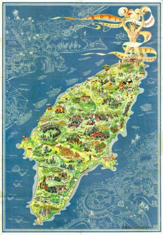
Out of stockPictorial map of Rhodes, the island of the sun or rose island in Greece by Egon Huber. Published by Ente Nazionale del Turismo Italiano in Milan at Pizzi & Pizzi, 1935. Shows roads, woods, forts, lighthouses, people in various recreational activities, etc. Also shows buildings, landmarks, ships and boats in white over blue sea. On verso 14 photos of Rodi as well as rich information about Rodi island. The list of the photos: “La citta…
- Dimension: 46,5 x 67 cm
- Place of publication: Milan
- Year: 1935
-
![]()
Miniature map of Pomerania embellished by rich cartouche, vessel and sea monters in the Baltic. From “Theatro del Mondo” the famous plagiarised version of Ortelius’ pocket atlas published specifically for the Italian market by Pietro Marchetti. First printed in Brescia this is the really rare Venetian edition of 1667. [cod.1213/15]
- Year: 1667
- Dimension: 75 x 105 mm
- Place of publication: Venice