Detailed antique map of Japan, divided into seven principal provinces and depicts numerous towns, mountains, and rivers. Finely engraved by Giuseppe Pitteri the map comes from Atlante Novissimo, illustrato ed accresciuto sulle osservazioni, e scoperte fatte dai piu celebri e piu recenti geografi by Antonio Zatta published in Venice in 1785.

[Japan] L’Impero Del Giapon diviso in sette principali parti cioe Ochio Quanto Jetsegen Jetsen Jamaisoit, Xicoco e Ximo …
- Year: 1779
- Dimension: 310 x 400 mm
- Place of publication: Venice
€ 400,00
Related products
-
![]()
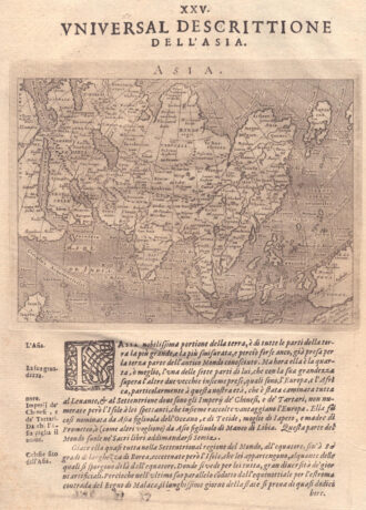
A map of the whole of Asia, with decorative figured cartouche. From ‘Atlante Novissimo’.
- Year: 1779
- Dimension: 305 x 405 mm
- Place of publication: Venice
-
![]()
Beautiful little map based on Ortelius? famous map of the Holy Land. It is oriented with east at the top and centered on Samaria. From the Mercator Hondius “Atlas Minor” published in Amsterdam in 1648 at Jannsonius with german text on verso. In 1607 Jodocus Hondius published a reduced size version of Mercator’s “Atlas”, itself suitably titled “Atlas Minor”. The maps were copied from those of the great cartographer Mercator of around 1580-90 or were reductions of Hondius’ own maps of 1606. Almos
- Year: 1648
- Dimension: 196 x 134 mm
- Place of publication: Amsterdam
-
![]()
Fascinating map of Asia based on Ortelius’with the exception of the addition of a strait dividing the southern portion of the Malay Peninsula. Interesting depiction of Japan, no sign of the Korean Peninsula. Includes region south of Nova Guinea that is marked as Terrae Incognita Australis, separated from Nova Guinea by a narrow channel. Engraved by Girolamo Porro for “Geografia di Claudio Tolomeo” by Giovanni Antonio Magini published in Padua, 1621.
- Year: 1621
- Dimension: 14 x 18 cm
- Place of publication: Padova
-
![]() Out of stock
Out of stockA lovely pictorial map of Japan published for social studies by le no Hikari in 1958.
- Dimension: 51 x 72 cm
- Place of publication: Tokyo
- Year: 1958