ZATTA Antonio
Showing 1–12 of 42 results
-
![]() Out of stock
Out of stockInteresting map of Newfoundland and Cap Breton Island, along with neighbouring Islands, including St. Pierre Michelon. From Atlante Novissimo, illustrato ed accresciuto sulle osservazioni, e scoperte fatte dai piu’ celebri e piu’ recenti cartografi by Antonio Zatta published in Venice in 1779. [cod.1170]
- Year: 1779
- Dimension: 420 x 315 mm
- Place of publication: Venice
-
![]() Out of stock
Out of stockA finely engraved copper plate map that covers Chili and most of Argentina. Good detail of the region around Buenos Ayres and the Rio de la Plata. Santiago here is named Rioja. A large inset details Tierra del Fuego and the Strait of Magellan. From “Atlante Novissimo, illustrato ed accresciuto sulle osservazioni, e scoperte fatte dai piu’ celebri e piu’ recenti cartografi” by Antonio Zatta published in Venice in 1779. [cod.1020/15]
- Year: 1779
- Dimension: 410 x 315 mm
- Place of publication: Venice
-
![]()
[Japan] L’Impero Del Giapon diviso in sette principali parti cioe Ochio Quanto Jetsegen Jetsen Jamaisoit, Xicoco e Ximo …
More Info € 400,00Detailed antique map of Japan, divided into seven principal provinces and depicts numerous towns, mountains, and rivers. Finely engraved by Giuseppe Pitteri the map comes from Atlante Novissimo, illustrato ed accresciuto sulle osservazioni, e scoperte fatte dai piu celebri e piu recenti geografi by Antonio Zatta published in Venice in 1785.
- Year: 1779
- Dimension: 310 x 400 mm
- Place of publication: Venice
-
![]()
Fine map of Netherlands from Antonio Zatta’s Atlante Novissimo, illustrato ed accresciuto sulle osservazioni, e scoperte fatte dai piu’ celebri e piu’ recenti cartografi published in Venice in 1779. A very little worm-hole on central overall in very good condition with nice and decorative original colours.
- Year: 1779
- Dimension: 420 x 320 mm
- Place of publication: Venice
-
![]()
A finely copper engraved map by G. Pitteri showing the modern-day nations of Uruguay, Paraguay, and parts of adjacent Brazil and Argentina.. Rich detail is offered throughout, naming mountains, rivers, national boundaries, cities, regions, and indigenous tribes. Identifies Asuncion, Buenos Aires, Rio de Janeiro, and numerous other important South American cities. From Atlante Novissimo, illustrato ed accresciuto sulle osservazioni, e scoperte fatte dai più celebri e più recenti cartografi by Antonio Zatta published in Venice in…
- Year: 1779
- Dimension: 400 x 320 mm
- Place of publication: Venice
-
![]()
Detailed map of Peru, extending from just North of Guayqauil to just South of the Tropic of Capricorn, showing the western Amazon, Andes, Lake Titicaca, and the many regions and Territories. From “Atlante Novissimo, illustrato ed accresciuto sulle osservazioni, e scoperte fatte dai piu’ celebri e piu’ recenti cartografi” by Antonio Zatta published in Venice in 1779-85. Antonio Zatta was a prominent Italian editor, cartographer, and publisher. Little is known about his life beyond his…
- Year: 1779
- Dimension: 407 x 310 mm
- Place of publication: Venice
-
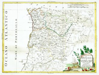
![]()
[Portugal] Il Portugallo Cioe Le Provincie di Entredouro, e Minho, Traz-Os-Montes, e Beira Di Nuova Projezione
More Info € 150,00Map of the northern half of Portugal, with attractive cartouche at lower right, showing moored ship with its cargo of barrels unloaded on the shore, next to a stone tablet on which is written the title. From Atlante Novissimo, illustrato ed accresciuto sulle osservazioni, e scoperte fatte dai più celebri e più recenti cartografi by Antonio Zatta published in Venice in 1779. Antonio Zatta was one of the leading cartographers and publishers of the time,…
- Year: 1779
- Dimension: 320 x 420 mm
- Place of publication: Venice
-
![]() Out of stock
Out of stockInteresting map of Russia in Asia from Atlante Novissimo, illustrato ed accresciuto sulle osservazioni, e scoperte fatte dai piu’ celebri e piu’ recenti cartografi by Antonio Zatta published in Venice in 1779.Very good condition with nice and decorative original colours.
- Year: 1779
- Dimension: 310 x 415 mm
- Place of publication: Venice
-
![]() Out of stock
Out of stockThe islands of Ibiza and Majorca, with a decorative title cartouche. Formentera appears within a scroll-like inset. From Atlante Novissimo, illustrato ed accresciuto sulle osservazioni, e scoperte fatte dai più celebri e più recenti cartografi by Antonio Zatta published in Venice in 1779-1784 Antonio Zatta was one of the leading cartographers and publishers of the time, and his Atlante Novissimo was one of the most beautifully produced of 18th-century atlases. He drew on the work…
- Year: 1779
- Dimension: 230 x 420 mm
- Place of publication: Venice
-
![]()
Detailed map of the eastern coastline of Spain, centred on Valencia, Murcia and the Balearic Islands of Ibiza, Minorca and Majorca. From Atlante Novissimo, illustrato ed accresciuto sulle osservazioni, e scoperte fatte dai più celebri e più recenti cartografi by Antonio Zatta published in Venice in 1779. Antonio Zatta was one of the leading cartographers and publishers of the time, and his Atlante Novissimo was one of the most beautifully produced of 18th-century atlases. He…
- Year: 1779
- Dimension: 300 x 400 mm
- Place of publication: Venice
-
![]()
This attractive map shows all of the continent in Zatta’s beautiful style that exemplifies his fine engraving. The map extends to include part of Central America and south to show all of Patagonia and the Straits of Magellan. The title cartouche rests in the lower left corner and features plants and fruit. The map names and delineates each political region, and is filled with place names and good detail of rivers and mountains. From Atlante…
- Year: 1779
- Dimension: 300 x 400 mm
- Place of publication: Venice
-
![]()
Copper engraving from “Atlante Novissimo, illustrato ed accresciuto sulle osservazioni, e scoperte fatte dai piu’ celebri e piu’ recenti cartografi” by Antonio Zatta published in Venice in 1779.Very good condition with nice and decorative original colours.
- Year: 1779
- Dimension: 320 x 410 mm
- Place of publication: Venice