The very fine and interesting map shows the boundaries of the US immediately prior to Texas claiming its independence. Many Indian Tribes and early forts noted. Insets of Texas and St. Pierre Miquelon. From Atlas Spheroidal et Universel de Geographie by M.F.A. Garnier published in Paris at Veuve Jules Renouard in 1862. This atlas is exceptional for its “spheroidal” maps of the globe, showing the various continents and poles, shaded to give the effect of a sphere floating in space. The remaining maps are also very well executed and colored. This is the only atlas that Garnier produced, according to Phillips. (836) [cod.1091/15]

Etats-Unis de l’Amerique du Nord. Limites en 1835.
- Year: 1862
- Dimension: 340 x 500 mm
- Place of publication: Paris
€ 200,00
Related products
-
![]()
Lovely engraved map based on the cartography by C. Franz Radefeld (1788-1874) showing the Arkansas, Mississipi, Louisiana, Alabama and Florida Panhandle. Inset of New Oreleans suurndings. From the “Meyer’s Neuester Zeitungs Atlas” published by Bibliographischen Instituts in Hildburghausen in 1849-52. The innovation of this work is that almost all maps had small inserts showing richly detailed maps of major cities and their surrunding areas: so not only could travellers carry the atlas with them
- Year: 1849
- Dimension: 270 x 200 mm
- Place of publication: Hildburghausen
-
![]()
Lovely engraved map based on the cartography by C. Franz Radefeld (1788-1874) showing part of United States which includes insets of New York City, Philadelphia, Niagara Falls, Albany, Pittsburgh and the Baltimore – Washington DC area. From the “Meyer’s Neuester Zeitungs Atlas” published by Bibliographischen Instituts in Hildburghausen in 1849-52. The innovation of this work is that almost all maps had small inserts showing richly detailed maps of major cities and their surrunding areas: so…
- Year: 1849
- Dimension: 200 x 265 mm
- Place of publication: Hildburghausen
-
![]()
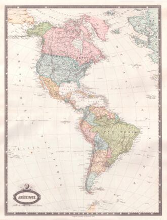
Interesting map of America with high detail and beautiful decorative colouring. The Panama Canal has not yet been built. Colombia is “Nouvelle Grenade” and Alaska is “Amerique Russe”. Much of the Amazon is labeled as “Selvas”, or tropical rainforests, and “Région Inconnue”. From Atlas Spheroidal et Universel de Geographie by M.F.A. Garnier published in Paris at Veuve Jules Renouard in 1862. This atlas is exceptional for its “spheroidal” maps of the globe, showing the various…
- Year: 1862
- Dimension: 680 x 510 mm
- Place of publication: Paris
-
![]()
Etats-Unis du Mexique, Amerique Centrale, comprenant les Republiques de Guatemala….
More Info € 180,00Very detailed map of Mexico with the Caribbean includes an inset of Central America and Panama. Interesting Depiction of Arizona and New Mexico. From Atlas Spheroidal et Universel de Geographie by M.F.A. Garnier published in Paris at Veuve Jules Renouard in 1862. This atlas is exceptional for its “spheroidal” maps of the globe, showing the various continents and poles, shaded to give the effect of a sphere floating in space. The remaining maps are also…
- Year: 1862
- Dimension: 340 x 500 mm
- Place of publication: Paris