Very detailed map of Mexico with the Caribbean includes an inset of Central America and Panama. Interesting Depiction of Arizona and New Mexico. From Atlas Spheroidal et Universel de Geographie by M.F.A. Garnier published in Paris at Veuve Jules Renouard in 1862. This atlas is exceptional for its “spheroidal” maps of the globe, showing the various continents and poles, shaded to give the effect of a sphere floating in space. The remaining maps are also very well executed and colored. This is the only atlas that Garnier produced, according to Phillips. (836)

Etats-Unis du Mexique, Amerique Centrale, comprenant les Republiques de Guatemala….
- Year: 1862
- Dimension: 340 x 500 mm
- Place of publication: Paris
€ 180,00
Related products
-
![]()
A fine map of North America with a lovely detailed depiction of the East Coast. A large lake is shown in present day Idaho. The interesting map was engraved with great care by James Barlow. Published in London in 1807.
- Dimension: 18 x 21,5 cm
- Place of publication: London
- Year: 1807
-
![]()
Lovely engraved map based on the cartography by C. Franz Radefeld (1788-1874) showing the Arkansas, Mississipi, Louisiana, Alabama and Florida Panhandle. Inset of New Oreleans suurndings. From the “Meyer’s Neuester Zeitungs Atlas” published by Bibliographischen Instituts in Hildburghausen in 1849-52. The innovation of this work is that almost all maps had small inserts showing richly detailed maps of major cities and their surrunding areas: so not only could travellers carry the atlas with them
- Year: 1849
- Dimension: 270 x 200 mm
- Place of publication: Hildburghausen
-
![]()
Charming classical pocket map of Pacific coast of Mexico. From the Mercator Hondius “Atlas Minor” published in Amsterdam in 1648 at Jannsonius with german text on verso. In 1607 Jodocus Hondius published a reduced size version of Mercator’s “Atlas”, itself suitably titled “Atlas Minor”. The maps were copied from those of the great cartographer Mercator of around 1580-90 or were reductions of Hondius’ own maps of 1606. Almost 20 years later Joannes Janssonius commissioned a…
- Year: 1648
- Dimension: 190 x 135 mm
- Place of publication: Amsterdam
-
![]()
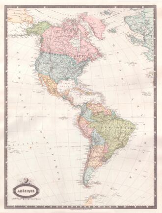
Interesting map of America with high detail and beautiful decorative colouring. The Panama Canal has not yet been built. Colombia is “Nouvelle Grenade” and Alaska is “Amerique Russe”. Much of the Amazon is labeled as “Selvas”, or tropical rainforests, and “Région Inconnue”. From Atlas Spheroidal et Universel de Geographie by M.F.A. Garnier published in Paris at Veuve Jules Renouard in 1862. This atlas is exceptional for its “spheroidal” maps of the globe, showing the various…
- Year: 1862
- Dimension: 680 x 510 mm
- Place of publication: Paris