Italy
Showing 61–72 of 411 results
-
![antica carta sicilia]() Out of stock
Out of stockAn uncommon map of Sicily based on the map of the Royal Topographical Office of Naples published in 1826. The map, published as a loose sheet, is not dated, but it is probably one of the many representations of the island published around 1860 to meet the demands of a market attentive to the political and military events of that period. In April 1860 the revolt of the city of Palermo against the Bourbons of…
- Dimension: 65 x 50 cm
- Place of publication: Turin
- Year: 1860
-
![]() Out of stock
Out of stockPrima edizione della grande e interessantissima carta murale dell’alta Italia che documenta la situazione politica del paese alla fine del 1797. I confini della Cisalpina sono quelli deliberati con il Trattato di Capoformio e sul Veneto si legge: “Stati della Casa d’Austria”; la carta riporta i nomi dei dipartimenti, da cui si evince che Nizza e Savoia non appartengono più al Piemonte, e su Massa si legge “dipartimento delle Alpi Apuane” denominazione usata dalla metà…
- Year: 1797
- Dimension: 720 x 1445 mm
- Place of publication: Florence
-
![]() Out of stock
Out of stockJ. M. Ziegler’s interesting map focuses on the road and railway system, standing out for its attention to topography and for accurately depicting Alpine crossings during a time when the distinction between lowland and mountain roads was keenly felt. The map highlights communication routes, prominently featuring railways marked in red, distinguishing between those already built and those nearing completion. Notably, the Milan-Bologna railway was contested by the Austrians due to its potential to unite the…
- Dimension: 42 x 74 cm
- Place of publication: Winterthur
- Year: 1853
-
![carta lombardo veneto]() Out of stock
Out of stockLarge map of the Kingdom of Lombardy-Venetia drawn by Gaetano Monticelli here in the final edition of 1866, which is characterised by the beautiful and detailed representation of Istria. Interesting and precise is the orography designed with a particular stroke to give a sense of three-dimensionality to the reliefs. The important river system of the territory and the rich toponymy with the indication of many urban centres, even minor ones, are highlighted. First and second class communication routes are indicated, as well as those that can be travelled, with the relevant post stations The map is completed in the bottom left-hand corner by the table with the ‘Prospetto Statistico delle Provincie del Regno Lombardo Veneto’ (Statistical Prospectus of the Provinces of the Lombardy-Veneto Kingdom). Published in Milan in 1866 at Artaria.
- Dimension: 52 x 89,5 cm
- Place of publication: Milan
- Year: 1866
-
![]() Out of stock
Out of stockNon comune carta geografica dello Stato di Milano disegnata dall’ingegnere militare Giovanni Battista Sesti e tratta dall’opera Piante delle città, piazze e castelli fortificati in questo stato di Milano edita da Francesco Agnelli nel 1707. Il territorio mostrato si allarga oltre lo Stato di Milano coprendo buona parte del Piemonte, della Repubblica di Genova, dello Stato di Parma e del Mantovano. L’incisione è di gran fascino principalmente per una certa semplicità compositiva ad esempio nell’orografia;…
- Dimension: 31 x 20 cm
- Place of publication: Milan
- Year: 1707
-
![carta gastronomica verona lago di garda]() Out of stock
Out of stockA vibrantly colored pictorial food map of Verona and Lake of Garda, designed by Gianni Ainardi in 1968 to promote tourism in the area.
- Dimension: 35 x 49 cm
- Place of publication: Verona
- Year: 1968
-
![]() Out of stock
Out of stockCarta Generale del Regno Lombardo-Veneto ridotta dalla Carta Topografica nell’Istituto Geografico Militare dell’I.R. Stato Maggiore Generale
More InfoCarta del Lombardo-Veneto pubblicata in 4 fogli riportati su tela a stacchi e custoditi nell’astuccio originale in cartoncino verde. In basso a sinistra i due titoli, in italiano e in tedesco, la legenda con la spiegazione dei segni convenzionali, elenco delle divisioni territoriali in 17 provincie di Lombardia e Venezia, indicazioni editoriali e scala delle distanze. L’interessante orografia è rappresentata col tratteggio a luce zenitale nel territorio sono indicate le stazioni di posta, le miniere,…
- Dimension: 95 x 152 cm
- Place of publication: Milan
- Year: 1838
-
![]() Out of stock
Out of stockCarta Geografica e Postale del Regno Lombardo Veneto compilata sulle migliori Carte generali e provinciali … disegnata da Domenico Lillié
More InfoCarta geografica del Regno Lombardo Veneto incisa da Giuseppe Pezze sotto la direzione dell’I. R. Primo Tenente Ingegnere Geografo in pensione Giovanni Brenna. Nell’angolo in alto a sinistra un riquadro con il titolo, le attribuzioni di responsabilità e i dati editoriali mentre nell’angolo in basso a destra sotto l’indicazione delle scale metriche sono riportati i segni convenzionali che riguardano le Poste, Porti e Passaggi, Strade Postali e Provinciali. In basso a sinistra una interessante tabella…
- Dimension: 45 x 79 cm
- Place of publication: Milan
- Year: 1848
-
![]()
Carta geografica e postale del Regno Lombardo Veneto compilata sulle migliori carte generali e provinciali esistenti
More Info € 500,00Wall map of the Lombardy-Venetia Kingdom published in Milan in 1851 at Giovanni Cogliati’s printing house. The map, drawn by C. Pinchetti and G. Brenna, was engraved by Giuseppe Pezze. It is embellished in the lower part by the topographic maps of the main cities of the Kingdom: Como, Pavia, Lodi, Bergamo, Milan, Sondrio, Cremona, Brescia, Mantua, Verona, Vicenza, Rovigo, Padua, Venice, Belluno, Treviso, and Udine, accompanied by interesting historical information and statistical tables.
- Dimension: 86 x 130 cm
- Place of publication: Milan
- Year: 1851
-
![]() Out of stock
Out of stockStriking large geological map of Lombardy by Torquato Taramelli. Published by Artaria in Milan, 1890.
- Dimension: 85 x 80 cm
- Place of publication: Milan
- Year: 1890
-
![]()
A beautiful map with the best and interesting footpaths around Courmayeur. In the top left corner a list of the mountain trails for an enjoyable and safe experience. At bottom left the Cinzano ad for its vermouth. The uncommon lithograph map drawn by Gino Veragnez-Marino was published by Guide Illustrate Reynaudi for the local tourist office in 1920 circa.
- Dimension: 24 x 29 cm
- Place of publication: Turin
- Year: 1920
-
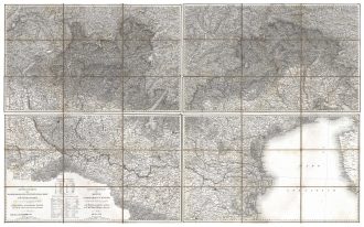
![]() Out of stock
Out of stockNorthern Italy’s detailed map stands out due to its beautiful representation of the landscape and the innovative approach of marking not only the altitude of the mountains but also of the towns in the area. The warning in the bottom right-hand corner, placed under the legend of the conventional signs, is significant: “this map follows the one in a single sheet engraved and published by the Royal Corps of Staff”; therefore, the map is related…
- Dimension: 60 x 83 cm
- Place of publication: Turin
- Year: 1859