Interesting town plan of the walled city of Valenza from the rare Schauplatz des Krieges In Italien, Oder Accurate Beschreibung der Lombardey by Thomas Fritschen published in Leipzig in 1702.

La città di Valenza
Interesting town plan of the walled city of Valenza from the rare Schauplatz des Krieges In Italien, Oder Accurate Beschreibung der Lombardey by Thomas Fritschen published in Leipzig in 1702.
- Year: 1702
- Dimension: 70 x 130 mm
- Place of publication: Lipsia
€ 90,00
Related products
-
![]() Out of stock
Out of stockInteresting town plan of the walled city of Villanuova d’Asti from the rare Schauplatz des Krieges In Italien, Oder Accurate Beschreibung der Lombardey by Thomas Fritschen published in Leipzig in 1702.
- Year: 1702
- Dimension: 70 x 130 mm
- Place of publication: Lipsia
-
![]() Out of stock
Out of stockCorso del Po per la Lombardia dalle sue fonti fino al mare co’ fiumi che in esso scaricano …
More InfoImportante e grande carta geografica incisa in rame da Antonio Barbey su tre fogli uniti che mostra l’intero Corso del fiume Po attraverso l’Italia settentrionale. Basata sui rilevamenti del cartografo Agostino Cerruti e pubblicata a Roma da Domenico de Rossi nel 1703. Nell’angolo inferiore sinistro vi è un cartiglio contenente il titolo “Dato in Luce da Domenico de Rossi dalle sue Stampe in Roma alla Pace / con licenza de Superiori, e Priuilegio del Sommo…
- Dimension: 58 x 120,5 cm
- Place of publication: Rome
- Year: 1703
-
![]()
Miniature map from “Neu aussgeffertigter kleiner Atlas” by J. Muller published in Franckfurt in 1702 at Johann Philip Andrea. Engraved with great care by G. Karsch e G. Bodeneher. Rare. [cod.346/15]
- Year: 1702
- Dimension: 70 x 80 mm
- Place of publication: Frankfurt
-
![]()
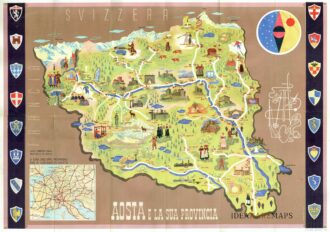
Manifesto pubblicitario che mostra disegno della Valle d’Aosta con monumenti e figure in abiti tradizionali affiancato da oggetti e monumenti tipici del territorio. In alto a destra figura allegorica e stilizzata delle tipicità della regione con fucile, sci, racchetta da tennis, picozza, corda e macchina fotografica. In basso a sinistra riquadro con carta del nord Italia e lungo i lati successione di otto stemmi per parte. Al verso fotografie di diverse località ed un testo illustrativo delle caratteristiche della Valle d’Aosta. Pubblicato dall’Ente Nazionale Industrie Turistiche presso lo stampatore Pizzi & Pizio nel 1937-38. Confronta Collezione Salce, Museo Nazionale 05165
- Dimension: 48 x 68 cm
- Place of publication: Rome
- Year: 1937