Miniature map from “Neu aussgeffertigter kleiner Atlas” by J. Muller published in Franckfurt in 1702 at Johann Philip Andrea. Engraved with great care by G. Karsch e G. Bodeneher. Rare. [cod.346/15]


Pedemontium
Miniature map from “Neu aussgeffertigter kleiner Atlas” by J. Muller published in Franckfurt in 1702 at Johann Philip Andrea. Engraved with great care by G. Karsch e G. Bodeneher. Rare. [cod.346/15]
- Year: 1702
- Dimension: 70 x 80 mm
- Place of publication: Frankfurt
€ 150,00
Related products
-
![]()
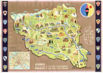
Manifesto pubblicitario che mostra disegno della Valle d’Aosta con monumenti e figure in abiti tradizionali affiancato da oggetti e monumenti tipici del territorio. In alto a destra figura allegorica e stilizzata delle tipicità della regione con fucile, sci, racchetta da tennis, picozza, corda e macchina fotografica. In basso a sinistra riquadro con carta del nord Italia e lungo i lati successione di otto stemmi per parte. Al verso fotografie di diverse località ed un testo illustrativo delle caratteristiche della Valle d’Aosta. Pubblicato dall’Ente Nazionale Industrie Turistiche presso lo stampatore Pizzi & Pizio nel 1937-38. Confronta Collezione Salce, Museo Nazionale 05165
- Dimension: 48 x 68 cm
- Place of publication: Rome
- Year: 1937
-
![]() Out of stock
Out of stockFine Homann’s map of the Po River
- Dimension: 119 x 52 cm
- Place of publication: Nuremberg
- Year: 1735
-
![]()
A very fine map from the first edition of “Geographia di Claudio Tolomeo” by Girolamo Ruscelli published in Venice in 1561 at Valgrisi. There is a really interesting Italian text on verso that describes the early history and geography of the area. A feature of this first state is that some maps haven’t the platemark at top because two maps were engraved on the same plate and the resulting sheet halved. Ruscelli’s Atlas is an expanded edition of Gastaldi’s Atlas of 1548, which has been called the most comprehensive atlas produced between Martin Waldseemller’s Geographiae of 1513, and the Abraham Ortelius Theatrum of 1570. Gastaldi’s maps were beautifully engraved on copper, marking a turning point in the history of cartography. From then on the majority of cartographic works used this medium. As it was a harder material than wood it gave the engraver the ability to render more detail. Gastaldi sought the most up-to-date geographical information available, and [he] became one of the greatest cartographers of the sixteenth century.
- Year: 1561
- Dimension: 180 x 240 mm
- Place of publication: Venice
-
![]()
Interesting town plan of the walled city of Novara from the rare Schauplatz des Krieges In Italien, Oder Accurate Beschreibung der Lombardey by Thomas Fritschen published in Leipzig in 1702.
- Year: 1702
- Dimension: 70 x 130 mm
- Place of publication: Lipsia