Germany
Showing 13–18 of 18 results
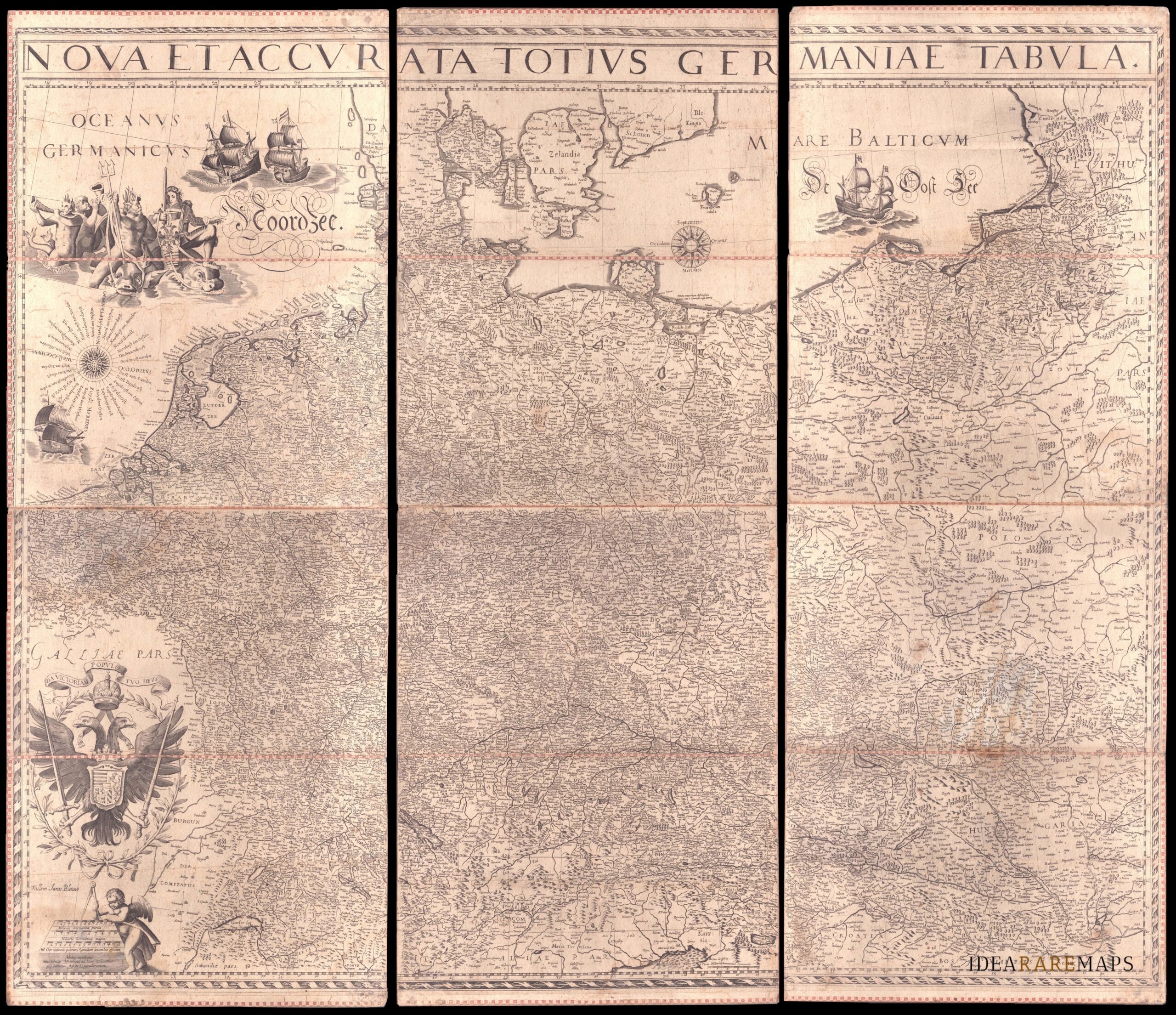
-
![]()
An exceptional wall map of the German Empire showing the Netherlands, Germany, Switzerland, Austria, Bohemia, Moravia, Poland and the Baltic Countries. Only three other copies are known to Schilder. Contemporary mounted on cardboard.
- Dimension: 108 x 125 cm
- Place of publication: Amsterdam
- Year: 1639
-
![]()
Very detailed and decorative map in two sheets of Cologne showing in great care the course of Rhine from Coronelli’s Corso Geografico Universale published in Venice in 1690. Vincenzo Maria Coronelli is widely recognised as one of Italy?s most famous and greatest cartographers. He received an ecclesiastical education at the convent of the Minor Conventuals and also studied theology in Rome. However, his interests in geography and cartography were awoken early in his ecclesiastical career and neve
- Year: 1690
- Dimension: 450 x 610 mm each
- Place of publication: Venice
-
![]()
A most decorative map of Prussia. It replaced the older map (v.d.Broecke, map 156) in the editions from 1595 on. It is based on the large woodcut map of Prussia by Caspar Henneberg of 1576. Van den Broecke: 157
- Year: 1603
- Dimension: 367 x 468 mm
- Place of publication: Antwerp
-
![]()
Lower Saxony and Mecklenburg are the central theme of this appealing map. It covers from Lubeck and the Baltic Sea in the north to Celle, Rathenow and Spandau in the south. Adorned with strapwork title and scale cartouches. From the Mercator Hondius “Atlas Minor” published in Amsterdam in 1648 at Jannsonius. In 1607 Jodocus Hondius published a reduced size version of Mercator’s “Atlas”, itself suitably titled “Atlas Minor”. The maps were …
- Year: 1648
- Dimension: 195 x 145 mm
- Place of publication: Amsterdam
-
![]()
Important and rare map of this Germany’s area. In 1578, Gerard De Jode published his atlas entitled Speculum Orbis Terrarum.This work, likely due to the strong market presence of Ortelius’ Theatrum Orbis Terrarum, sold poorly. This map comes from the second and last edition of the Atlas by Cornelis De Jode. [cod.1240/15]
- Year: 1593
- Dimension: 305 x 506 mm
- Place of publication: Antwerp
-
![]()
Importante grande incisione all’acquaforte con particolari al bulino di Orazio Farinati basato sul trittico del padre Paolo eseguito nel 1573 per la Chiesa dei Cappuccini a Verona. Terzo stato di cinque riconoscibile dalla data “1583” del I stato che qui stata corretta in “1593”; dall’aggiunta dell’indirizzo di Dall’Olio in basso al centro; dall’angolo del rame tagliato in basso a sinistra. [cod.1151/15]
- Year: 1616
- Dimension: 190 x 146 mm
- Place of publication: Amsterdam