Delightful small map of the ancient Turkish empire covering the Middle East (including Arabia and Oman) from the Mercator Hondius “Atlas Minor” published in Amsterdam in 1648 at Jannsonius with german text on verso. In 1607 Jodocus Hondius published a reduced size version of Mercator’s “Atlas”, itself suitably titled “Atlas Minor”. The maps were copied from those of the great cartographer Mercator of around 1580-90 or were reductions of Hondius’ own maps of 1606. Almost 20 years later Joannes Janssonius commissioned a new set of copperplates to be engraved by Pieter Van Den Keere (Kaerius) and Abraham Goos. These maps were elegantly designed with decorative title cartouches, finely engraved and surprisingly detailed for their dimensions. Koeman “Atlantes Neerlandici” Me203.

Related products
-
![]()
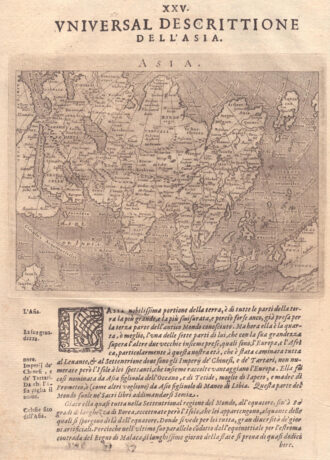
Fascinating map of Asia based on Ortelius’with the exception of the addition of a strait dividing the southern portion of the Malay Peninsula. Interesting depiction of Japan, no sign of the Korean Peninsula. Includes region south of Nova Guinea that is marked as Terrae Incognita Australis, separated from Nova Guinea by a narrow channel. Engraved by Girolamo Porro for “Geografia di Claudio Tolomeo” by Giovanni Antonio Magini published in Padua, 1621.
- Year: 1621
- Dimension: 14 x 18 cm
- Place of publication: Padova
-
![]()
One of the earliest obtainable modern maps of the Holy Land, which appeared in the first edition of Munster’s Geographia, first published in Basle in 1540. Here in the 1552 edition easily recognized by the presence of latitude and longitude borders. The map extends from Sidon and the land of the Phoenians in the north to Gaza in the south with numerous Biblical sites and a number of vignettes. The inset is a key of ancient and modern placenames. This map is orientated with west at the top and is based on earlier maps by Munster and Ziegler. From the rare “Geographia Universalis, Vetus et Nova, complectens Claidii Prolemaei Alexandrini enarrationis libros VIII” published in Basel at Heinrich Petri in 1552.
- Year: 1552
- Dimension: 285 x 378 mm
- Place of publication: Basle
-
![]()
[Japan] L’Impero Del Giapon diviso in sette principali parti cioe Ochio Quanto Jetsegen Jetsen Jamaisoit, Xicoco e Ximo …
More Info € 400,00Detailed antique map of Japan, divided into seven principal provinces and depicts numerous towns, mountains, and rivers. Finely engraved by Giuseppe Pitteri the map comes from Atlante Novissimo, illustrato ed accresciuto sulle osservazioni, e scoperte fatte dai piu celebri e piu recenti geografi by Antonio Zatta published in Venice in 1785.
- Year: 1779
- Dimension: 310 x 400 mm
- Place of publication: Venice
-
![]()
This miniature version of Ortelius’ important map of Southeast Asia shows how sketchy the available information was concerning the region. The East Indies are presented as a randomly scattered group of islands with Java and Borneo particularly misshapen. Beach pars, a presumed promontory of the great southern continent based on Marco Polo’s account, protrudes into the bottom of the map. Japan is presented in its kite-shaped form, and in the upper right corner America makes…
- Year: 1598
- Dimension: 75 x 105 mm
- Place of publication: Antwerp