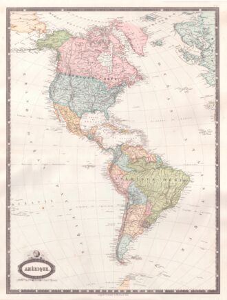
Interesting map of North America engraved on copper by Glot. From the scarce “Atlas Portatif, contenant la Gographie Universelle Ancienne et Moderne” by Eustache Herisson published in Paris in 1809 at Desray.
Out of stock

L’Amerique Septentrionale
Interesting map of North America engraved on copper by Glot. From the scarce “Atlas Portatif, contenant la Gographie Universelle Ancienne et Moderne” by Eustache Herisson published in Paris in 1809 at Desray.
- Year: 1809
- Dimension: 218 x 180 mm
- Place of publication: Paris
Related products
-
![]()
Amerique ou Noveau Continent dresse sur le nouvelle relations decouvertes et observations par J.B. Nolin
More Info € 700,00A fascinating engraved map dated third years after the French revolution showing all of North and South America published in Paris by Basset, based upon work of Johann Baptist Nolin. The map includes a large inset map showing the “New Discoveries” in the Northwest part of America, most notably the depiction of prospective routes from Hudson’s Bay and Baffin’s Bay to the Pacific Ocean, based upon information provided by Joseph Nicolas De L’Isle, reporting on…
- Year: 1795
- Dimension: 470 x 680 mm
- Place of publication: Paris
-
![]()
Fine example of Coronelli’s map of the Caribbean. Centered on Hispaniola the map shows from the Southern tip of Florida and the Canal di Bahama to the Yucatan, to the Easternmost Antilles and Trinidad. Includes also the Caymans, Virgin Islands and smaller islands of the coast of Mexico. The cartouche also contains a dedication to Sebastiano Bernardi. Vincenzo Maria Coronelli is widely recognised as one of Italy?s most famous and greatest cartographers. He received an…
- Year: 1690
- Dimension: 257 x 430 mm
- Place of publication: Venice
-
![]()
The very fine and interesting map shows the boundaries of the US immediately prior to Texas claiming its independence. Many Indian Tribes and early forts noted. Insets of Texas and St. Pierre Miquelon. From Atlas Spheroidal et Universel de Geographie by M.F.A. Garnier published in Paris at Veuve Jules Renouard in 1862. This atlas is exceptional for its “spheroidal” maps of the globe, showing the various continents and poles, shaded to give the effect of…
- Year: 1862
- Dimension: 340 x 500 mm
- Place of publication: Paris
-
![]()
Interesting map of America with high detail and beautiful decorative colouring. The Panama Canal has not yet been built. Colombia is “Nouvelle Grenade” and Alaska is “Amerique Russe”. Much of the Amazon is labeled as “Selvas”, or tropical rainforests, and “Région Inconnue”. From Atlas Spheroidal et Universel de Geographie by M.F.A. Garnier published in Paris at Veuve Jules Renouard in 1862. This atlas is exceptional for its “spheroidal” maps of the globe, showing the various…
- Year: 1862
- Dimension: 680 x 510 mm
- Place of publication: Paris