Interesting map of the world on Mercator’s projection engraved on copper by Glot. The map is detailed and cartographically up-to-date. Showing also the routes of explorers, including the Cook’s and La Perouse. From the scarce “Atlas Portatif, contenant la Gographie Universelle Ancienne et Moderne” by Eustache Herisson published in Paris in 1809 at Desray.
Out of stock

Carte Generale des Parties Connues du Globe
Interesting map of the world on Mercator’s projection engraved on copper by Glot. The map is detailed and cartographically up-to-date. Showing also the routes of explorers, including the Cook’s and La Perouse. From the scarce “Atlas Portatif, contenant la Gographie Universelle Ancienne et Moderne” by Eustache Herisson published in Paris in 1809 at Desray.
- Year: 1809
- Dimension: 243 x 190 mm
- Place of publication: Paris
Related products
-
![]()
A beautiful pictorial map of the world, showing the routes flown by French Airline Union de Transports Aériens. The world centered on Pacific is depicted physical with a nice colors.
The map shows UTA’s routes to the African Continent from Paris, primarily flying to former French colonies in West Africa, as well as to Karachi, Athens, Bangkok, Saigon, Singapore, Djakarta, Darwin and French Polynesia. Routes to Honolulu and Los Angeles from Papeete are also shown.
Union de Transports Aériens (UTA), formed in 1963 as a result of a merger between Union Aéromaritime de Transport (UAT) and Transports Aériens Intercontinentaux (TAI), was the largest wholly privately owned, independent airline in France. It was absorbed into Air France between 1990 and 1992.- Dimension: 49 x 68 cm
- Place of publication: Paris
- Year: 1965
-
![]() Out of stock
Out of stockRare pictorial world map designed in the style of 17th century maps by the British painter and artist Gordon Davey (1912-1992) for Pakistan Airlines in 1960. The map is an interesting and curious mix between the classic geographical representations of the golden age of explorations (the wind rose, the numerous cartouches, sea monsters, galleons) and close modernity: in each country are depicted lovely little vignettes with ancient and modern reference: see for example the Roman…
- Dimension: 45,5 x 25,5 cm
- Year: 1960
-
![]() Out of stock
Out of stockColor pictorial map of the world showing travel Lufthansa’s routes and connections with Lufthansa plane flying over map of the world. Map representing landmarks, major cities, and people. Includes compass rose decorated with Lufthansa logo.
- Dimension: 46,5 x 72 cm
- Place of publication: Berlin-Schonefeld
- Year: 1962
-
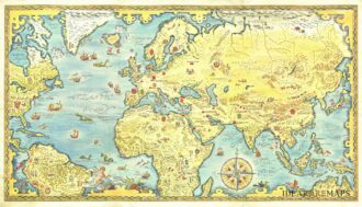
![]()
A large very decorative Japanese world map published as sugoroku (a Japanese game which might be compared to backgammon) published as a supplement to the 1930 New Year’s Day edition of the Osaka Mainichi Shimbun newspaper. The really interesting map is drawn on a Mollweide projection instead the more commonly used Mercator projection: cartographers use the Mollweide projection when an accurate representation of area takes precedence over the accuracy of shapes. Countries are in shades…
- Dimension: 1070 x 770 mm
- Place of publication: Osaka
- Year: 1930