1947
Showing all 4 results
-
![]() Out of stock
Out of stockLarge pictorial map showing the handicraft products of each Spanish town through lovely vignettes. Published in Barcelona in 1947 at the Llauger S.A. for the trade union association of artisans based in Madrid.
- Dimension: 86 x 70 cm
- Year: 1947
-
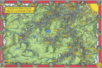
![]() Out of stock
Out of stockFine 1947 pictorial map by MacDonald Gill showing the Colne Valley Cloth District in Yorkshire, England.
- Dimension: 33 x 49 cm
- Place of publication: London
- Year: 1947
-
![]() Out of stock
Out of stockDiese Weltkarte zeigt die Arbeit des Menschen und die Schätze und Wirtschaftsgüter der Erde
More InfoGrande e dettagliatissima carta pittoresca del mondo disegnata da F. Heinrichsen che mostra attraverso deliziose vignette l’ingegno e l’operosità dell’uomo e le caratteristiche di tutte le aeree della Terra: accanto a ogni toponimo sono infatti riportate le caratteristiche del luogo come per esempio il tabacco a Cuba, il rum e lo zucchero nelle isole caraibiche, oro e diamanti in alcune aree dell’Africa, petrolio in Arabia, le famose olive di Creta o le vignette degli agrumi…
- Dimension: 114 x 66,5 cm
- Place of publication: Stuttgart
- Year: 1947
-
![]() Out of stock
Out of stockPictorial world map designed as gameboard by Lucien Boucher
- Dimension: 50 x 65 cm
- Place of publication: Paris
- Year: 1947