Large map by R. Hausermann showing the Catholic Missions in the United States, with an extensive table below listing statistics on the Church in the U.S in 1900. Published by Dufrenoy in Paris, 1900. Strong stable paper with few usual holes/creases where the folds cross. Cfr. Rumsey Collections: 4879000

Missions Catholiques Aux Etats-Unis
- Dimension: 71 x 95 cm
- Place of publication: Paris
- Year: 1900
€ 180,00
Related products
-
![antica mappa islanda groenlandia]()
Fascinating map of the region bounded by Hudson’s Bay, Iceland, Greenland, and Baffin Bay, showing the Arctic Regions and detailing the prospects for a passage from the Atlantic to the Pacific via the legendary Northwest Passage. From the rarest and most elegant cartographic work by Francesco Celestino Marmocchi, the Corso di Geografia Commerciale published in Genoa in 1858.
- Dimension: 25 x 38 cm
- Place of publication: Genoa
- Year: 1858
-
![]()
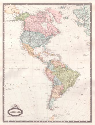
Interesting map of America with high detail and beautiful decorative colouring. The Panama Canal has not yet been built. Colombia is “Nouvelle Grenade” and Alaska is “Amerique Russe”. Much of the Amazon is labeled as “Selvas”, or tropical rainforests, and “Région Inconnue”. From Atlas Spheroidal et Universel de Geographie by M.F.A. Garnier published in Paris at Veuve Jules Renouard in 1862. This atlas is exceptional for its “spheroidal” maps of the globe, showing the various…
- Year: 1862
- Dimension: 680 x 510 mm
- Place of publication: Paris
-
![]()
Carte De L’Amerique Septenrionale et Meridionale … les Decourverts Les plus nouvelles et les trois Voyages de Cook, MacKenzie et Vancouver…1809
More Info € 800,00Rare map of America and the discoveries in the Pacific Ocean. Published separately by Eustace Herisson in Paris in 1809 at Bisset. The map shows a large and detailed map of the Americas, the Pacific, New Zealand and the Atlantic Ocean with engraved routes of explorations of Cook, Vancouver and Mackenzie. [cod.1233/15]
- Year: 1809
- Dimension: 760 x 520 mm
- Place of publication: Paris
-
![]()
A particularly attractive pictorial map of Alsace, Lorraine, Vosges and Jura in the Burgundy Franche-Comté in France by anonymous author published in 1930 circa. This map is covered with vignettes describing major towns and landmarks along the roads. Includes decorative cartouche, compass rose and inset lovely views illustrating Obernai, Reims, Colmar, Auxerre, Strasbourg. Uncommon.
- Dimension: 24 x 34 cm
- Year: 1930