Territorio di Orvieto

 350,00

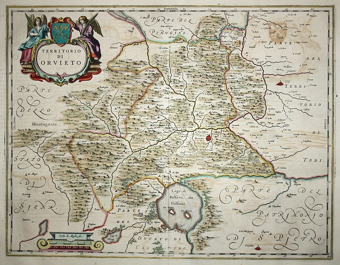
Map of the Orvieto region taken from Johannes Blaeu’s famous *Atlas Major*, published in Amsterdam in 1664, with Flemish text on the reverse. The territory is bounded by regions clearly indicated in the marginal bands—part of the Perugino region to the north, the State of Siena to the west, the Duchy of Castro to the south, and part of the Patrimony of St. Peter and Todi to the east—accurately depicting the complex political mosaic of papal central Italy. Orvieto stands out at the center of the composition, depicted with an urban vignette on its characteristic tuff cliff, while the southern portion is dominated by the blue expanse of Lake Bolsena (formerly Vulsinus), identified by its Latin name.

In the upper left corner, the map is dominated by an elaborate heraldic cartouche enclosing the title “Territory of Orvieto” within a Mannerist-Baroque frame, flanked by two winged angelic figures holding the papal shield with the Keys of St. Peter—an explicit emblem of the temporal sovereignty of the Papal States over the Orvieto territory. In the lower left corner, a graphic scale labeled “Scala di Miglia sei” is housed within an architectural structure resembling a pedestal, a recurring decorative motif in Blaeu’s work.

The cartographic basis of the map is based on the surveys conducted by Giovanni Antonio Magini (Padua 1555 – Bologna 1617), a mathematician, astronomer, and cosmographer who held the chair of mathematics at the University of Bologna for nearly thirty years. Magini devoted the final phase of his life to compiling *Italia*, a regional atlas of the Italian peninsula that remained unfinished at the time of his death and was published posthumously by his son Fabio in Bologna in 1620. The work, the result of an immense effort to collect and coordinate local surveys from across the peninsula, served for decades as the reference source for Italian cartography and was systematically incorporated into the great Dutch atlases of the seventeenth century.

The Atlas Maior, sive Cosmographia Blaviana is universally regarded as the most magnificent achievement in 17th-century cartography and the most ambitious typographical work ever produced in modern-era Europe. Published in Amsterdam, the atlas comprised twelve volumes in its most complete edition—featuring 594 maps and approximately 3,000 pages of descriptive text; it was translated and marketed in Dutch, Latin, French, Spanish, and German, thereby catering to the educated markets of all of Europe. The selling price was extraordinarily high: a hand-colored copy could cost as much as the entire library of a wealthy professional, making the *Atlas Maior* not only a geographical tool but a true symbol of social status, purchased by monarchs, aristocrats, and wealthy merchants as a demonstration of culture and power. Production took place at the famous Blaeu workshop on the Bloemgracht in Amsterdam, which had nine presses for intaglio printing and six for letterpress printing, employing dozens of artisans specialized in engraving, printing, coloring, and bookbinding. The tragic destruction of the printing house in the fire of 1672 brought an end to that extraordinary enterprise.

Joan (Johannes) Blaeu was born in Alkmaar around 1598 to Willem Janszoon Blaeu, founder of the most important Dutch cartographic dynasty. After studying law in Leiden—where he earned his doctorate—and completing the customary peregrinatio academica among European universities, Joan joined his father in managing the printing house in Amsterdam, inheriting its leadership upon Willem’s death in 1638 alongside his brother Cornelis. Under his leadership, the publishing house reached the height of its success: in 1638, Joan was appointed official cartographer of the Dutch East India Company (VOC), a position of extraordinary prestige that granted him privileged access to the most up-to-date geographical information from the four corners of the world. His most famous work, the *Atlas Maior*, was the culmination of thirty years of systematically compiling copperplate engravings, geographical texts, and cartographic updates. Joan Blaeu was also a prominent figure in Amsterdam’s civic life: a member of the city council for several terms, he held leading administrative positions in the city, which was then the center of world trade. He died in Amsterdam in 1673, one year after the fire that destroyed his printing shop and, with it, irreversibly ended Dutch dominance in European cartographic production—a dominance that would soon pass into the hands of the great French publishers, from Sanson to De L’Isle.