


Vivace e non comune carta geografica pittorica che mostra la Costa Azzurra da Mentone e Montecarlo fino a Tolone e che celebra La corniche d’Or (o corniche de l’Estérel), la famosa strada che costeggia il Mediterraneo ai piedi del Massiccio dell’Estérel tra le località di Fréjus (Varo) e Mandelieu-la-Napoule (Alpi Marittime). La carta fu pubblicata nel 1950 per promuovere la SACO, société des Auto-Cars de la Corniche d’Or con sede a Saint-Raphaël che si occupava di trasporti e sevizi automobilistici per lo più a carattere turistico in Costa Azzurra. Dall’epoca romana fino alla fine del XIX secolo per andare da Fréjus a Cannes si poteva solo attraversare il Massiccio dell’Estérel. Tra il 1901 e il 1903 fu quindi costruita lungo la costa una strada per iniziativa del Touring Club de France e con il sostegno della Compagnia ferroviaria da Parigi a Lione e il Mediterraneo. È un percorso turistico lungo 27 km, con 183, che attraversa più volte il percorso della ferrovia, ma senza alcun passaggio a livello. Sono numerosi i film con delle scene girate lungo la pittoresca Corniche d’Or, tra cui: Atoll K di John Berry e Léo Joannon, Colpo grosso ma non troppo di Gérard Oury, Il clan dei siciliani di Henri Verneuil e Il truffacuori di Pascal Chaumeil.
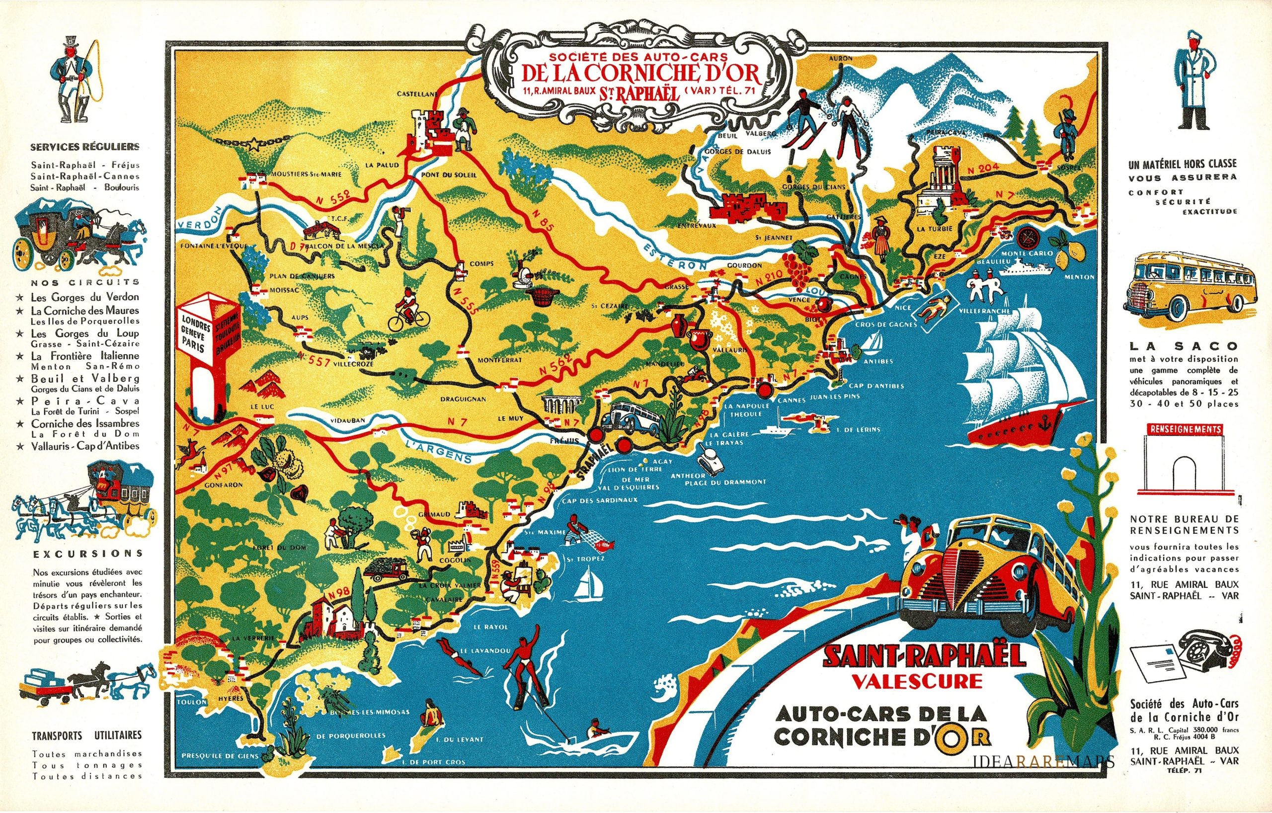
Saint-Raphael Valescure Auto-cars de la Corniche D’Or
Lovely Pictorial map of French Riviera centered on Saint-Raphael. Published in 1950 for SACO, société des Auto-Cars de la Corniche d’Or.
- Dimension: 27 x 43 cm
- Year: 1950
Related products
-
![]()
Li Governi del Berry, del Nivernois, della Marche, del Bourbonnois e dell’ Auvergne
More Info € 150,00Copper engraving from “Atlante Novissimo, illustrato ed accresciuto sulle osservazioni, e scoperte fatte dai piu’ celebri e piu’ recenti cartografi” by Antonio Zatta published in Venice in 1779. Very good condition with nice and decorative original colours. [cod.1020/15]
- Year: 1779
- Dimension: 410 x 310 mm
- Place of publication: Venice
-
![]()
A particularly attractive pictorial map of Ardennes in the north of France centered on Lille and Arras by anonymous author published in 1930 circa. This map is covered with vignettes describing major towns and landmarks along the roads. Includes decorative cartouche, compass rose and inset lovely views illustrating Dieppe, Abbeville, Amiens, Rouen, Harfleur and Le Touquet. Uncommon.
- Dimension: 24 x 34 cm
- Year: 1930
-
![]()
Engraved hand-colored in outline, double-page map of northeastern France, including Burgundy and Lyon, with title cartouche. Shows administrative divisions, towns, villages, forests, mountains and rivers. From Atlante Novissimo, illustrato ed accresciuto sulle osservazioni, e scoperte fatte dai più celebri e più recenti cartografi by Antonio Zatta published in Venice in 1779. In very good condition with nice and decorative original colours.
- Year: 1779
- Dimension: 420 x 320 mm
- Place of publication: Venice
-
![]()
Isola del Re
- Year: 1690
- Dimension: 460 x 270 mm
- Place of publication: Venice


