A lovely 1914-18 Great War satirical postcard dated on verso 29 May 1915.

Map of Europe Zog it off
A lovely 1914-18 Great War satirical postcard dated on verso 29 May 1915.
- Dimension: 90 x 140 mm
- Place of publication: London
- Year: 1915
€ 120,00
Related products
-
![]()
Very rare map engraved by Elias Baeck from ?Der curiose und .. Nssliche Dollmetscher..? published in Augsburg in 1748. The map has decorative cartouche and a nice original colouring. Missing in many reference.
- Year: 1748
- Dimension: 220 x 155 mm
- Place of publication: Augsburg
-
![]()
Charming map of the region centered on Hereford from the Mercator Hondius “Atlas Minor” published in Amsterdam in 1648 at Jannsonius with german text on verso. In 1607 Jodocus Hondius published a reduced size version of Mercator’s “Atlas”, itself suitably titled “Atlas Minor”. The maps were copied from those of the great cartographer Mercator of around 1580-90 or were reductions of Hondius’ own maps of 1606. Almost 20 years later Joannes Janssonius commissioned a new set of copperplates to be e
- Year: 1648
- Dimension: 205 x 155 mm
- Place of publication: Amsterdam
-
![]()
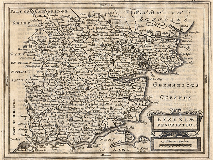
Charming map of Essex with nice depiction of London in the left bottom corner from the Mercator Hondius “Atlas Minor” published in Amsterdam in 1648 at Jannsonius with german text on verso. In 1607 Jodocus Hondius published a reduced size version of Mercator’s “Atlas”, itself suitably titled “Atlas Minor”. The maps were copied from those of the great cartographer Mercator of around 1580-90 or were reductions of Hondius’ own maps of 1606. Almost 20 years later Joannes Janssonius commissioned a n
- Year: 1648
- Dimension: 205 x 155 mm
- Place of publication: Amsterdam
-
![]()
Copper engraving from “Atlante Novissimo, illustrato ed accresciuto sulle osservazioni, e scoperte fatte dai piu’ celebri e piu’ recenti cartografi” by Antonio Zatta published in Venice in 1779.Very good condition with nice and decorative original colours.
- Year: 1779
- Dimension: 400 x 310 mm
- Place of publication: Venice