A very fine map from the first edition of “Geographia di Claudio Tolomeo” by Girolamo Ruscelli published in Venice in 1561 at Valgrisi. There is a really interesting Italian text on verso that describes the early history and geography of the area. A feature of this first state is that some maps haven’t the platemark at the top because two maps were engraved on the same plate and the resulting sheet halved. Ruscelli’s Atlas is an expanded edition of Gastaldi’s Atlas of 1548, which has been called the most comprehensive atlas produced between Martin Waldseemuller’s Geographiae of 1513, and the Abraham Ortelius Theatrum of 1570. Gastaldi’s maps were beautifully engraved on copper, marking a turning point in the history of cartography. From then on the majority of cartographic works used this medium. As it was a harder material than wood it gave the engraver the ability to render more detail. Gastaldi sought the most up-to-date geographical information available, and [he] became one of the greatest cartographers of the sixteenth century.

Related products
-
![]()
Carte itineraire physique politique et routiere de l’Espagne et du Portugal: indiquant les trois grandes Regions geographiques les ancines et les nouvelles Divisions
More Info € 600,00This extremely uncommon carte-a-figures map from the 19th century features the Iberian Peninsula and is surrounded with defly engraved figures and representations of places of note in Spain and Portugal. The vignettes flanking the map include Alhambra, Malaga, The Giralda Bell Tower of the Cathedral of Seville, Burgos Cathedral, Tower of Orangers in Seville, St. Nicholas’s Tower in Cordova, the Carmel Convent, Madrid, Lisbon and El Prado in addition to others. The figures below the map include a bull fighter and typical attire for residents of various parts of Spain and Portugal. The map is filled with details of roads, towns and cities, as well as topography and was made as a folding map to assist travelers in the region.
- Dimension: 53,5 x 73 cm
- Place of publication: Paris
- Year: 1840
-
![]()
Miniature map from “Neu aussgeffertigter kleiner Atlas” by J. Muller published in Franckfurt in 1702 at Johann Philip Andrea. Engraved with great care by G. Karsch e G. Bodeneher. Rare.
- Year: 1702
- Dimension: 70 x 80 mm
- Place of publication: Frankfurt
-
![]()
Detailed map of Portugal oriented with the north to the right from the Mercator Hondius Atlas Minor published in Amsterdam in 1648 at Jannsonius with german text on verso. In 1607 Jodocus Hondius published a reduced-size version of Mercator’s “Atlas”, itself suitably titled “Atlas Minor”. The maps were copied from those of the great cartographer Mercator of around 1580-90 or were reductions of Hondius’ own maps of 1606. Almost 20 years later Joannes Janssonius commissioned…
- Year: 1648
- Dimension: 203 x 140 mm
- Place of publication: Amsterdam
-
![]()
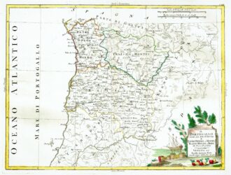
[Portugal] Il Portugallo Cioe Le Provincie di Entredouro, e Minho, Traz-Os-Montes, e Beira Di Nuova Projezione
More Info € 150,00Map of the northern half of Portugal, with attractive cartouche at lower right, showing moored ship with its cargo of barrels unloaded on the shore, next to a stone tablet on which is written the title. From Atlante Novissimo, illustrato ed accresciuto sulle osservazioni, e scoperte fatte dai più celebri e più recenti cartografi by Antonio Zatta published in Venice in 1779. Antonio Zatta was one of the leading cartographers and publishers of the time,…
- Year: 1779
- Dimension: 320 x 420 mm
- Place of publication: Venice