Nice town view of Barth Pommern in Mecklenburg-Vorpommern from Bertius’s “Commentariorum rerum germanicum libri tres” published in Amsterdam at Jannsonius in 1616.
- Sorry, this product cannot be purchased.

Barth in Pommern
Nice town view of Barth Pommern in Mecklenburg-Vorpommern from Bertius’s “Commentariorum rerum germanicum libri tres” published in Amsterdam at Jannsonius in 1616.
€ 100,00
Related products
-
![]() Out of stock
Out of stockBeautifully engraved map of ancient Germany showing in hight details the northern Europe from the Adriatic to the Baltic and Netherlands.
Really interesting the latin nomenclature of the cities, town rivers and mountains.
From the 1624 final edition of Ortelius’s “Parergon in quo Veteris Geographiae aliquot tabulae… – Nomenclator Ptolemaicus” with the text by Balthasar Moretus.
Ortelius’s Parergon began as a companion to his Theatrum but eventually it became an independent work. In fact, this collection of maps of the ancient world was so significant that it became the model for all historical atlases published throughout the seventeenth century. The maps and plates in the Parergon have to be evaluated as the most outstanding engravings depicting the wide-spread interest in classical geography in the 16th century (Koeman).- Year: 1624
- Dimension: 366 x 472 mm
- Place of publication: Antewerp
-
![]()
Fine and detailed map of Cologne and Dusseldorff from the Mercator Hondius “Atlas Minor” published in Amsterdam in 1648 at Jannsonius. In 1607 Jodocus Hondius published a reduced size version of Mercator’s “Atlas”, itself suitably titled “Atlas Minor”. The maps were copied from those of the great cartographer Mercator of around 1580-90 or were reductions of Hondius’ own maps of 1606. Almost 20 years later Joannes Janssonius commissioned a new set of …
- Year: 1648
- Dimension: 190 x 140 mm
- Place of publication: Amsterdam
-
![]()
Lovely small map of Upper Sachsen and Schlesien centered roughly on Meissen with place names, rivers and forests. From the Mercator Hondius “Atlas Minor” published in Amsterdam in 1648 at Jannsonius. In 1607 Jodocus Hondius published a reduced size version of Mercator’s “Atlas”, itself suitably titled “Atlas Minor”. The maps were copied from those of the great cartographer Mercator of around 1580-90 or were reductions of Hondius’ own maps of 1606.
- Year: 1648
- Dimension: 195 x 145 mm
- Place of publication: Amsterdam
-
![]()
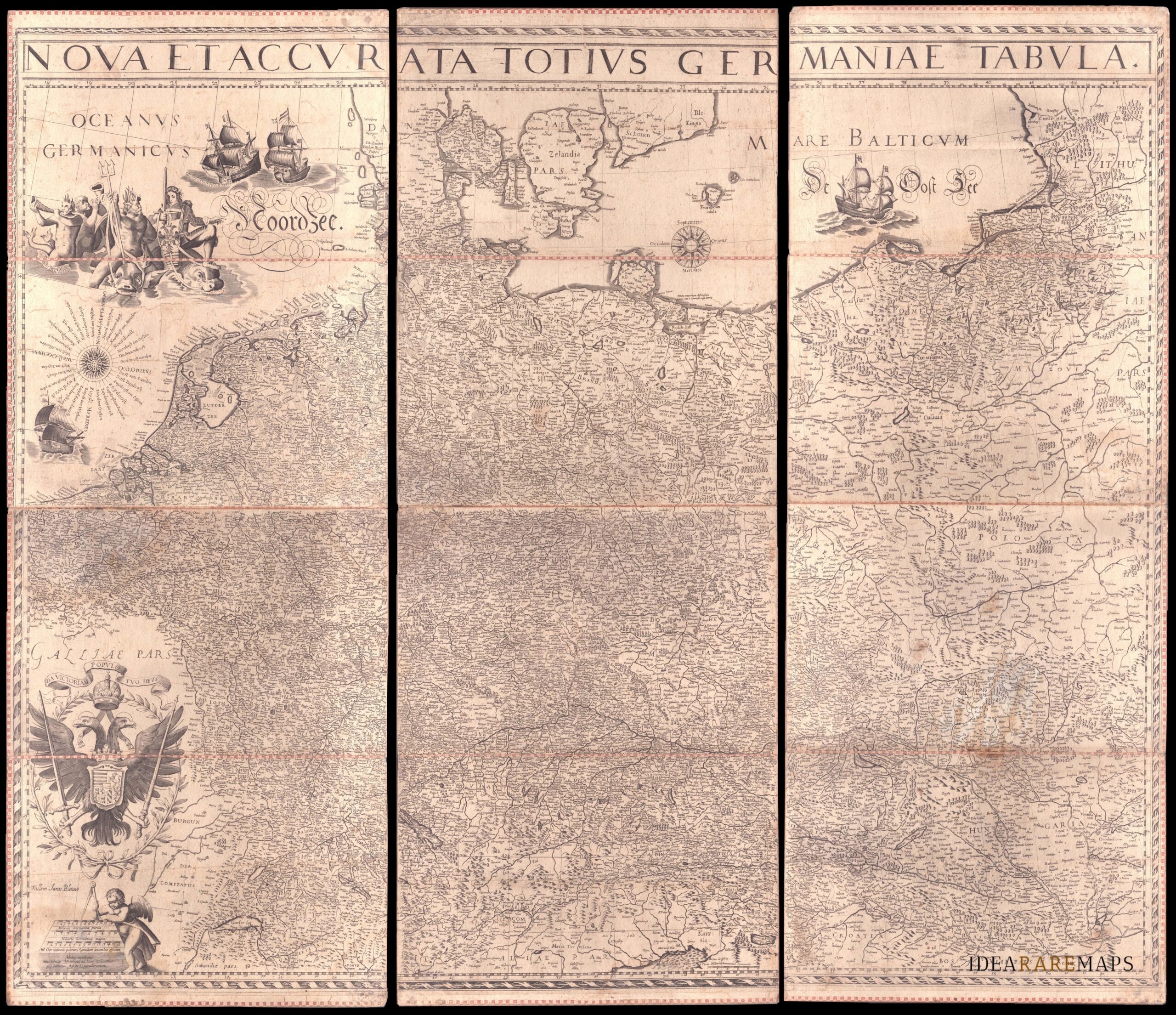
An exceptional wall map of the German Empire showing the Netherlands, Germany, Switzerland, Austria, Bohemia, Moravia, Poland and the Baltic Countries. Only three other copies are known to Schilder. Contemporary mounted on cardboard.
- Dimension: 108 x 125 cm
- Place of publication: Amsterdam
- Year: 1639