Very decorative lithographic poster map designed by Kempster and Evans issued by Chromoworks in London in 1956. The map shows historical figures in costume and is bordered by the coat of arms or shields of various counties.

Map of Royal Britain
Very decorative lithographic poster map designed by Kempster and Evans issued by Chromoworks in London in 1956. The map shows historical figures in costume and is bordered by the coat of arms or shields of various counties.
- Dimension: 610 x 970 mm
- Year: 1956
- Place of publication: London
€ 280,00
Related products
-
![]()
One of only four maps of English counties by this Italian mapmaker. From ‘Atlante Novissimo’. Very good condition with nice and decorative original colours. [cod.1020/15]
- Year: 1779
- Dimension: 200 x 305 mm
- Place of publication: Venice
-
![]()
The Beatles Map shows a topographic layout of Liverpool highlighting the places well known (it also has their Yellow Submarine characters & the sub itself in the Mersey!) to Beatles buffs such as Quarrybank High School, their birthplaces & many other Beatle landmarks. Printed in darkgreen on light green paper by City of Liverpool Public Relations Office and published in 1974 to commemorate the buildings and places where the Beatles started their career.
- Dimension: 37 x 42,5 cm
- Year: 1974
-
![]()
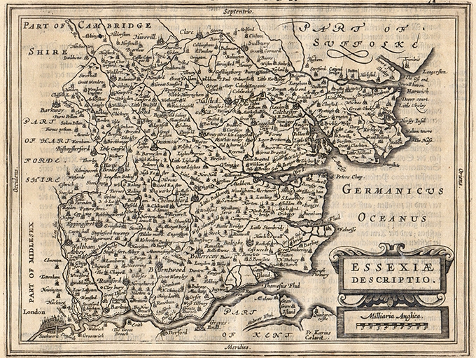
Charming map of Essex with nice depiction of London in the left bottom corner from the Mercator Hondius “Atlas Minor” published in Amsterdam in 1648 at Jannsonius with german text on verso. In 1607 Jodocus Hondius published a reduced size version of Mercator’s “Atlas”, itself suitably titled “Atlas Minor”. The maps were copied from those of the great cartographer Mercator of around 1580-90 or were reductions of Hondius’ own maps of 1606. Almost 20 years later Joannes Janssonius commissioned a n
- Year: 1648
- Dimension: 205 x 155 mm
- Place of publication: Amsterdam
-
![]()
Charming map of the region centered on Hereford from the Mercator Hondius “Atlas Minor” published in Amsterdam in 1648 at Jannsonius with german text on verso. In 1607 Jodocus Hondius published a reduced size version of Mercator’s “Atlas”, itself suitably titled “Atlas Minor”. The maps were copied from those of the great cartographer Mercator of around 1580-90 or were reductions of Hondius’ own maps of 1606. Almost 20 years later Joannes Janssonius commissioned a new set of copperplates to be e
- Year: 1648
- Dimension: 205 x 155 mm
- Place of publication: Amsterdam