1960
Showing all 6 results
-
![]() Out of stock
Out of stockGrande e non comune manifesto che mostra una rappresentazione geografica pittorica della Corsica animata da numerosi navi e aerei in arrivo e in partenza dall’isola a sottolinearne la vivacità commerciale e turistica. Disegnata da Gabriel Carriat-Roland la carta mostra gli agglomerati urbani come piccole ma realistiche vedute con in evidenza le caratteristiche principali (vedi la statua di Napoleone ad Ajaccio). In basso due grandi illustrazioni riassumo le peculiarità commerciali, flora, fauna e le tipiche abitazioni…
- Dimension: 90 x 60 cm
- Place of publication: Paris
- Year: 1960
-
![]()
Pictorial map of Gargano, the stunning region that encompasses the mountainous promontory of the same name in the northern part of Apulia, Foggia province. Created for the Manfredonia Tourist Board and released in 1960 by Rimini publisher Bruno Ghigi, the map features 49 framed views showcasing the area’s most distinctive and picturesque buildings and landscapes. It also highlights campsites, beaches, bays, and tourist villages along the coast. Additionally, whimsical vignettes in the sea portray tourists, boats, and bathers, adding a touch of charm to the map’s purpose.
- Dimension: 62 x 86 cm
- Place of publication: Rimini
- Year: 1960
-
![]()
Large poster of the Compagnie Générale Transatlantique designed by A. Lapree and M. Lezla, published in 1960 by Blondel La Rougery to promote the routes of the French shipping company. The map shows North Africa with the routes from French ports to the main landings in Algeria, Morocco, and Tunisia highlighted. At the bottom right is an insert with Corsica. It is enriched by a decorative wind rose and at the top by illustrations of one of the company’s liners and an aircraft to highlight the countries served by Air Algerie.
- Dimension: 60 x 95 cm
- Place of publication: Paris
- Year: 1960
-
![]() Out of stock
Out of stockSeparately issue version of Federico De Agostini stunning map of Italy, first published in 1946 by Italgeo. Published in Milan as ad for Motta, 1960. The illustrator of the pictorial map is Vsevolod Petrovic Nicouline: it shows vignettes of structures, nature, activities, products, crops and many towns and cities labeled. Embellished by elegant calligraphy, compass rose and a Neptune in the sea.
Vsevolod Petrovic Nicouline (1890-1962) was a renowned Russian painter, printmaker, ceramicist, designer and illustrator born in the Ukraine in 1890. For a time he was with the Imperial Academy of Petersburg. His teaching career there was interrupted by the Bolshevik revolution. He was forced to flee and, after a daring journey, arrived in Constantinople accompanied by the Countess Bossalinie Aida who later became his wife. They survived in this city with menial jobs, and were finally able to join relatives in Genoa in 1920 where he held his first exhibition. In 1922 he moved to Nervi, opening a studio at the first Polish residence, meeting other Russian and Polish exiles. His years were rich in relationships, artists, and writers for whom he designed several books and arranged illustrations, commissions of portraits and more. In 1941 he was inaugurated into the Teatro Carlo Felice and designed sets for La Scala and the Metropolitan New York. He was an important illustrator of more than 100 children’s books.- Dimension: 80 x 64 cm.
- Place of publication: Milan
- Year: 1960
-
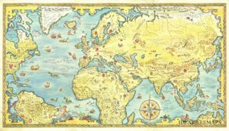
![]() Out of stock
Out of stockRare pictorial world map designed in the style of 17th century maps by the British painter and artist Gordon Davey (1912-1992) for Pakistan Airlines in 1960. The map is an interesting and curious mix between the classic geographical representations of the golden age of explorations (the wind rose, the numerous cartouches, sea monsters, galleons) and close modernity: in each country are depicted lovely little vignettes with ancient and modern reference: see for example the Roman…
- Dimension: 45,5 x 25,5 cm
- Year: 1960
-
![]() Out of stock
Out of stockStriking map showing the routes of Sabena Airlines throughout Africa, the Middle East, and Europe created in beautiful color patterns with the oceans surrounding it in blue tones. The map features many of the cities printed in gold, as well as the flight patterns that connect them together. The routes delineated in the map show the two main hubs of Sabena to be Brussels with Leopoldville, capital of the Belgian Congo (now Kinshasa, Democratic Republic of the Congo) with a large number of other destinations around and between them. African tribal art is used in this image as part of the design as well as the regional representation of ethnic people. Published in Brussels by Marci in 1960.
- Dimension: 100 x 64 cm
- Place of publication: Bruxelles
- Year: 1960