Amsterdam
Showing 37–48 of 104 results
-
![]()
[Italian only] Eccezionale pianta prospettica della citt di Brescia incisa e pubblicata da Donato Rascicotti nella inedita e sconosciuta versione con il cartiglio nella parte destra poi eliminato nella versione definitiva a causa della lunghezza del testo descrittivo che non poteva essere contenuto. Anche il cartiglio a sinistra contenente la dedica risulta vuoto a conferma del fatto che si tratti di primissima tiratura di prova. In basso 134 rimandi …
- Year: 1648
- Dimension: 205 x 150mm
- Place of publication: Amsterdam
-
![]()
Charming map of the region centered on Hereford from the Mercator Hondius “Atlas Minor” published in Amsterdam in 1648 at Jannsonius with german text on verso. In 1607 Jodocus Hondius published a reduced size version of Mercator’s “Atlas”, itself suitably titled “Atlas Minor”. The maps were copied from those of the great cartographer Mercator of around 1580-90 or were reductions of Hondius’ own maps of 1606. Almost 20 years later Joannes Janssonius commissioned a new set of copperplates to be e
- Year: 1648
- Dimension: 205 x 155 mm
- Place of publication: Amsterdam
-
![]()
Copper engraved map of the island with north oriented to the left. Fully engraved with detail of rivers, mountains, cities and towns. The famous Blaeu’s firm was founded in 1596 by Willem Janzoon Blaeu (1571-1638) then continued by his two sons Cornelius (1616-1648) and Johannis (1596-1673). Their greatest cartographic achievement was the publication of the magnificent Atlas Major with 600 maps all finely engraved and embellished by elaborate cartouches, heraldic detail and especially by splendi
- Year: 1664
- Dimension: 180 x 240 mm
- Place of publication: Amsterdam
-
![]() Out of stock
Out of stockLovely copper engraved maps of Cuba above Hispaniola, with smaller insets of Havana, Jamaica, Puerto Rico and Margarita. Usual printer?s defect for this edition at right where border did not print due the damage of the copper. Otherwise very good. From the Mercator Hondius “Atlas Minor” published in Amsterdam in 1648 at Jannsonius with german text on verso. In 1607 Jodocus Hondius published a reduced size version of Mercator’s “Atlas”, itself suitably titled “Atlas Minor”. The maps were copied
- Year: 1648
- Dimension: 180 x 143 mm
- Place of publication: Amsterdam
-
![mappa veneto]() Out of stock
Out of stockRaffinata carta geografica del Dominio Veneto basata sull’opera di Giovanni Antonio Magini dalla quale differisce per una attenzione maggiore per la realtà geo-politica: infatti a differenza del prototipo Maginiano qui si aggiungono i confini dei vari territori (“Trentino”, “Vicentino”, “Veronese” … ), si sottolinea il Mirandolano distinto da Modena e si nota l’aggiunta del toponimo del Forte di Fuentes a nord del lago di Como. Tratta dall’opera Atlas Novus, sive Descriptio Geographica Totius Orbis Terrarum……
- Dimension: 37 x 49,5 cm
- Place of publication: Amsterdam
- Year: 1636
-
![]() Out of stock
Out of stockElegante carta geografica dello Stato Veneto delimitata da un doppio rigo e dal bordo graduato con l’indicazione della latitudine e della longitudine. Arricchita da due cartigli con il titolo e la scala delle distanze, la piccola mappa presenta un’accurata descrizione dell’apparato fluviale e una ricca toponomastica. Si tratta della versione della mappa inizialmente contenuta nell’Atlas Minor del Mercator-Hondius del 1607 qui incisa da Petrus Kaerius (firma in basso a destra) per l’edizione dell’atlante tascabile di…
- Dimension: 15,5 x 20,5 cm
- Place of publication: Amsterdam
- Year: 1648
-
![]()
Uncommon map showing the duchy of Ferrara. To the south are Bologna and Ravenna and the surrounding areas. To the East is the Adriatic Sea. The central waterway is the Po river and its many tributaries. North of the Po is part of the course of the Adige river. Part of the charm of this map is that so much detail is given to the rivers which branch out like a cobweb on the map.…
- Year: 1700 ca.
- Dimension: 370 x 470 mm
- Place of publication: Amsterdam
-
![]()
Fine map of Mantova from the french edition of Atlas major published in Amsterdam in 1667. The famous Blaeu’s firm was founded in 1596 by Willem Janzoon Blaeu (1571-1638) then continued by his two sons Cornelius (1616-1648) and Johannis (1596-1673). Their greatest cartographic achievement was the publication of the magnificent Atlas Major with 600 maps all finely engraved and embellished by elaborate cartouches, heraldic detail and especially by splendid calligraphy. The Atlas Major represents one of the finest moments in cartography. The firm shut down in 1672 when their offices were destroyed during the Great Amsterdam fire. A year afterwards Johannis Blaeu died. The firm’s surviving stocks of plates and maps were gradually dispersed, some of the plates being bought by F. de Wit and Schenk and Valck, before final closure in 1695.
- Year: 1667
- Place of publication: Amsterdam
- Dimension: 380 x 500 mm
-
![]() Out of stock
Out of stockNice small map covering the area of parma and Piacenza in the italian region of Emilia from the Mercator Hondius “Atlas Minor” published in Amsterdam in 1648 at Jannsonius with german text on verso. In 1607 Jodocus Hondius published a reduced size version of Mercator’s “Atlas”, itself suitably titled “Atlas Minor”. [cod.228/15]
- Year: 1648
- Dimension: 201 x 155 mm
- Place of publication: Amsterdam
-
![]()
Eboracum Lincolnia, Derbia, Staffordia, Notinghamia, Lecestria, Rutlandia, et Norfolcia
More Info € 150,00Charming map of the northeast of England, comprising the counties of Yorkshire, Lincolnshire, Derbyshire, Staffordshire, Nottinghamshire, Leicestershire, Rutland and Norfolk from the Mercator Hondius “Atlas Minor” published in Amsterdam in 1648 at Jannsonius with german text on verso. In 1607 Jodocus Hondius published a reduced size version of Mercator’s “Atlas”, itself suitably titled “Atlas Minor”. The maps were copied from those of the great cartographer Mercator of around 1580-90 or were re
- Year: 1648
- Dimension: 205 x 145 mm
- Place of publication: Amsterdam
-
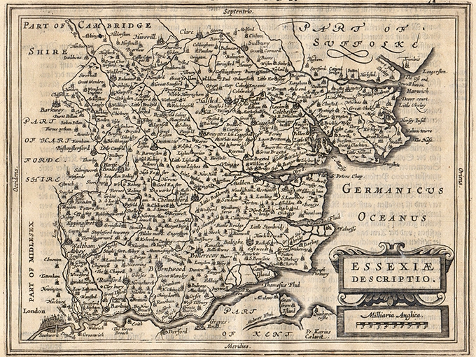
![]()
Charming map of Essex with nice depiction of London in the left bottom corner from the Mercator Hondius “Atlas Minor” published in Amsterdam in 1648 at Jannsonius with german text on verso. In 1607 Jodocus Hondius published a reduced size version of Mercator’s “Atlas”, itself suitably titled “Atlas Minor”. The maps were copied from those of the great cartographer Mercator of around 1580-90 or were reductions of Hondius’ own maps of 1606. Almost 20 years later Joannes Janssonius commissioned a n
- Year: 1648
- Dimension: 205 x 155 mm
- Place of publication: Amsterdam
-
![]() Out of stock
Out of stockA fine miniature map from “Epitome Theatri Orbis Terraum” published in Amsterdam in 1602.The maps were based from those in P. Galle’s final edition of 1598 but were drawn and engraved with great care. They may be easily recognised as they have a wide border with latitude and longitude shown. [cod.259/15]
- Year: 1602
- Dimension: 85 x 115 mm
- Place of publication: Amsterdam