14 x 18 cm

Showing all 9 results

  • Africa

    More Info  200,00

    Fascinating map of Africa and the Arabian Peninsula based on Ortelius and engraved by Girolamo Porro for “Geografia di Claudio Tolomeo” by Giovanni Antonio Magini published in Padua, 1621. The rivers of central and north Africa feature prominently including the Ptolemaic concept of the origin of the Nile in two lakes south of the Equator. The largest of these lakes also has a river flowing southeast.

    • Author: MAGINI Giovanni Antonio – TOLOMEO Claudio
    • Year: 1621
    • Dimension: 14 x 18 cm
    • Place of publication: Padova
  • America

    More Info  350,00

    Fine map by Giovanni Antonio Magini engrave day Girolamo Porro based on Giovanni Lorenzo d’Anania’s 1582 map of the Americas and further based on the geography of Ortelius. Most notable is the characteristic bulge to the west coast of South America and the huge Southern Continent that attaches to Nova Guinea. Anian and Quivira appear on North America’s bulbous western coast. From Geografia di Claudio Tolomeo published in Padua in 1621 at Galignani.

    • Author: MAGINI Giovanni Antonio – TOLOMEO Claudio
    • Year: 1621
    • Dimension: 14 x 18 cm
    • Place of publication: Padova
  • Asia

    More Info  200,00

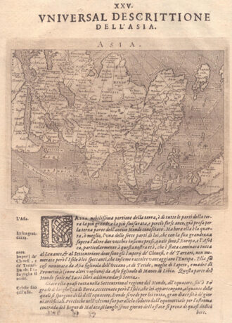
    Fascinating map of Asia based on Ortelius’with the exception of the addition of a strait dividing the southern portion of the Malay Peninsula. Interesting depiction of Japan, no sign of the Korean Peninsula. Includes region south of Nova Guinea that is marked as Terrae Incognita Australis, separated from Nova Guinea by a narrow channel. Engraved by Girolamo Porro for “Geografia di Claudio Tolomeo” by Giovanni Antonio Magini published in Padua, 1621.

    • Author: MAGINI Giovanni Antonio – TOLOMEO Claudio
    • Year: 1621
    • Dimension: 14 x 18 cm
    • Place of publication: Padova
  • antique map australia

    Australien

    More Info  100,00

    Lovely little map depicting Neu Holland (Australia), Neu Seeland (New Zealand), Neu Guinea, and numerous Pacific islands, including the Marquesas, the Caroline Islands, the Sandwich Islands (now Hawaii), and the Friendly Islands (present-day Tonga). It also features historical names for other regions, such as Van Diemen’s Land, the name by which Tasmania was known before its official renaming in 1856. This fascinating map comes from the children’s atlas Geographische Länder-Fibel by Julius Löwenberg, published in…

    • Author: Julius Löwenberg
    • Dimension: 14 x 18 cm
    • Place of publication: Berlin
    • Year: 1846
  • Europa

    More Info  150,00

    Fascinating map of Europe Asia based on Ortelius’ engraved by Girolamo Porro for “Geografia di Claudio Tolomeo” by Giovanni Antonio Magini published in Padua, 1621.

    • Author: MAGINI Giovanni Antonio – TOLOMEO Claudio
    • Year: 1621
    • Dimension: 14 x 18 cm
    • Place of publication: Padova
  • Italien

    More Info  100,00

    This delightful small map of Italy, published in 1846 in Julius Loewenberg’s children’s atlas Geographische Länder-Fibel, is a fascinating example of 19th-century cartography designed for educational purposes. At the center of the composition, the map of Italy showcases the pre-unification states, with their borders highlighted in beautiful contrasting colors: the Kingdom of Sardinia, the Kingdom of the Two Sicilies, the Papal States, and the Lombardo-Venetian Kingdom. Surrounding the map is an ornate frame featuring figures…

    • Author: Julius Löwenberg
    • Dimension: 14 x 18 cm
    • Place of publication: Berlin
    • Year: 1846
  • Nord Amerika

    More Info  120,00

    Charming antique map of North America from the children’s atlas Geographische LänderFibel by Julius Löwenberg, published in Berlin in 1846. The map provides an interesting depiction of the continent, with various territories distinguished by a beautiful chromatic arrangement. It marks the “Vereinigten Staaten” (United States), “Mexiko”, and the northern region still under the rule of Russisch-Amerika (Russian America, now Alaska, which was then a Russian possession). Texas is also indicated separately from Mexico, reflecting its…

    • Author: Julius Löwenberg
    • Dimension: 14 x 18 cm
    • Place of publication: Berlin
    • Year: 1846
  • Polen

    More Info  120,00

    Charming antique little map of Poland from Julius Löwenberg’s children’s atlas Geographische LänderFibel published in Berlin in 1846. The map offers an interesting description of the territory between Lithuania, Poland, Austria, and Russia after 1815 showing historical boundaries and including cities such as Warschau (Warsaw), Danzig (Danzig), Krakau (Kraków), Posen (Poznań), and other significant locations. The decorative frame features figures in traditional Polish dress and scenes evoking the daily life and culture of the area.…

    • Author: Julius Löwenberg
    • Dimension: 14 x 18 cm
    • Place of publication: Berlin
    • Year: 1846
  • Complete set with world map and four continents by G. Porro from “Geografia di Tolomeo” published in Padua in 1621 by Galignani.

    • Author: MAGINI Giovanni Antonio – TOLOMEO Claudio
    • Year: 1621
    • Dimension: 14 x 18 cm
    • Place of publication: Padova