SEUTTER Georg Matthaus
Showing all 7 results
-
![]() Out of stock
Out of stockInteresting map of Duchy of Milan and Kingdom of Venice centered on Lago di Garda. The map provides a remarkably detailed topographical view of the region north of the Alpennines, including the thriving commercial and agricultural regions from Turin and Milan to the low lying regions west of Venice, with many postal roads and other details shown. The map includes an elaborate title cartouche reflecting the military activity in the mountainous regions of the map,…
- Dimension: 47 x 57 cm
- Place of publication: Augsburg
- Year: 1730
-
![]() Out of stock
Out of stockCursus Padi per Longobardiam a fonte usque ad ostia… et adiacentibus Ducatibus ac Principatibus
More InfoFirst edition of the large Seutter’s map in three sheets showing the entire course of the Po river, from its source to its mouth, with a detailed representation of the neighbouring territories: Savoy, Piedmont, Monferrato, Lombardy, Parma, Modena, Ferrara, Bologna and Veneto. In the beautiful cartouche in the lower left-hand corner of the first plate, the title reveals that the three parts were destined to be joined together to form a single image ‘Tribus combinandis…
- Dimension: 57,5 x 131 cm
- Place of publication: Augsburg
- Year: 1734
-
![]()
Very fine map of the Sardinia, with a large allegorical title cartouche with animals and landscapes and 2 fine engraved cartouches at the bottom corners incorporating the scale on the left and a coat of arms on the right. From Seutter’s Atlas Novus published in Augsburg in 1730 ca. [cod.086/15]
- Year: 1730 ca.
- Dimension: 500 x 570 mm
- Place of publication: Augsburg
-
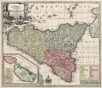
![antica mappa sicilia malta]() Out of stock
Out of stockA stunning map of Sicily published by M. Seutter in 1730. Inset at bottom a nice map of Malta and Gozo. Showing also the Etna erupting.
- Year: 1730
- Dimension: 580 x 500 mm
- Place of publication: Augsburg
-
![]()
Superb 18th century map of the whole of Italy that also includes the islands of Corsica and Sardina, part of Sicily and the coastline of Balkans. Beautifully engraved with Seutter’s typical bold style and detail. Title cartouche at top right features several cherubs and in the opposite corner features a distance scale with a river god, a globe and several putti. As usual, both cartouches are uncolored. Published in Augburg in 1725 ca. by M. Seutter.
- Year: 1725 ca.
- Dimension: 573 x 490 mm
- Place of publication: Augsburg
-
![]()
Superb 18th century map of the whole of Italy that also includes the islands of Corsica and Sardina, Sicily and the coastline of Balkans. Beautifully engraved with Seutter’s typical bold style and detail. Title cartouche at bottom left features several allegorical figures. Published in Augburg in 1734 by M. Seutter.
- Year: 1734
- Dimension: 490 x 573 mm
- Place of publication: Augsburg
-
![]() Out of stock
Out of stockGraziosa riduzione della carta dell’Italia del Seutter che nonostante le dimensioni riesce ad essere molto dettagliata e precisa. Arricchita da grande cartiglio allegorico con il titolo e un secondo, in alto a destra, con tre scale grafiche per le distanze. Tratta dall’opera Atlas Minor Praecipua Orbis Terrarum di Tobias Lotter edito ad Augsburg nel 1744.
- Year: 1744
- Dimension: 200 x 255 mm
- Place of publication: Augsburg