A lovely and uncommon map of the world in two hemispheres published in Paris by the pharmaceutical laboratories Neutroses-Vichy in 1939 at Petit Jean. The French colonies around the world are in red.
Out of stock

Nos Possessions des cinq Parties du Monde
A lovely and uncommon map of the world in two hemispheres published in Paris by the pharmaceutical laboratories Neutroses-Vichy in 1939 at Petit Jean. The French colonies around the world are in red.
- Dimension: 310 x 210 mm
- Place of publication: Paris
- Year: 1939
Related products
-
![]()
Striking map of Varese by Umberto Zimelli highlighting the interesting places and typical products throughout the area drawn in typical futuristic manner. One of the most interesting and decorative map of this area in northern Italy.
- Dimension: 47,5 x 34 cm
- Place of publication: Milan
- Year: 1949
-
![]()
Divertente carta dell’Italia divisa in regioni rappresentate come figure antropomorfe vincitrice nel 1908 del concorso geografico del Giornalino della Domenica, deliziosa pubblicazione per fanciulli, di Luigi Bertelli.
Il giornalino della Domenica fu un settimanale creato il 24 giugno 1906 da Luigi Bertelli, alias Vamba, nome tratto da Ivanhoe.
Scrissero per il giornalino, oltre allo stesso Vamba, scrittori e scrittrici celebri quali: Edmondo de Amicis, Luigi Capuana, Grazia Deledda, Ada Negri, Emilio Salgari, Antonio Beltramelli, Luisa Macina Gervasio (nota come Luigi di San Giusto). Nel 1925, confluì nel Giornalino della Domenica, comparendovi come un inserto autonomo, la rivista Giro Giro Tondo, fondata nel 1921 da Antonio Beltramelli.
Le illustrazioni erano eseguite dai migliori disegnatori dell’epoca quali: Antonio Rubino, Giuseppe Biasi, Mario Mossa De Murtas, Filiberto Scarpelli, Umberto Brunelleschi, Marcello Dudovich, Sergio Tofano.
Dopo alterne vicende ed interruzioni cessa definitivamente le pubblicazioni nel 1927.- Dimension: 36 x 27,5 cm
- Place of publication: Florence
- Year: 1908
-
![]()
An attractive miniature map showing detailed North America divided up into Mexico, the United States, Canada, Greenland and Russia Territory (Alaska). From popular Starling’s Victorian atlas “The Royal Cabinet Atlas, And Universal Compendium Of All Places In The Known World” published by Bull and Churton in London in 1833. The map is accompanied by a page of text giving the latitude and longitude of the major towns.
- Year: 1833
- Dimension: 90 x 145 mm
- Place of publication: London
-
![]()
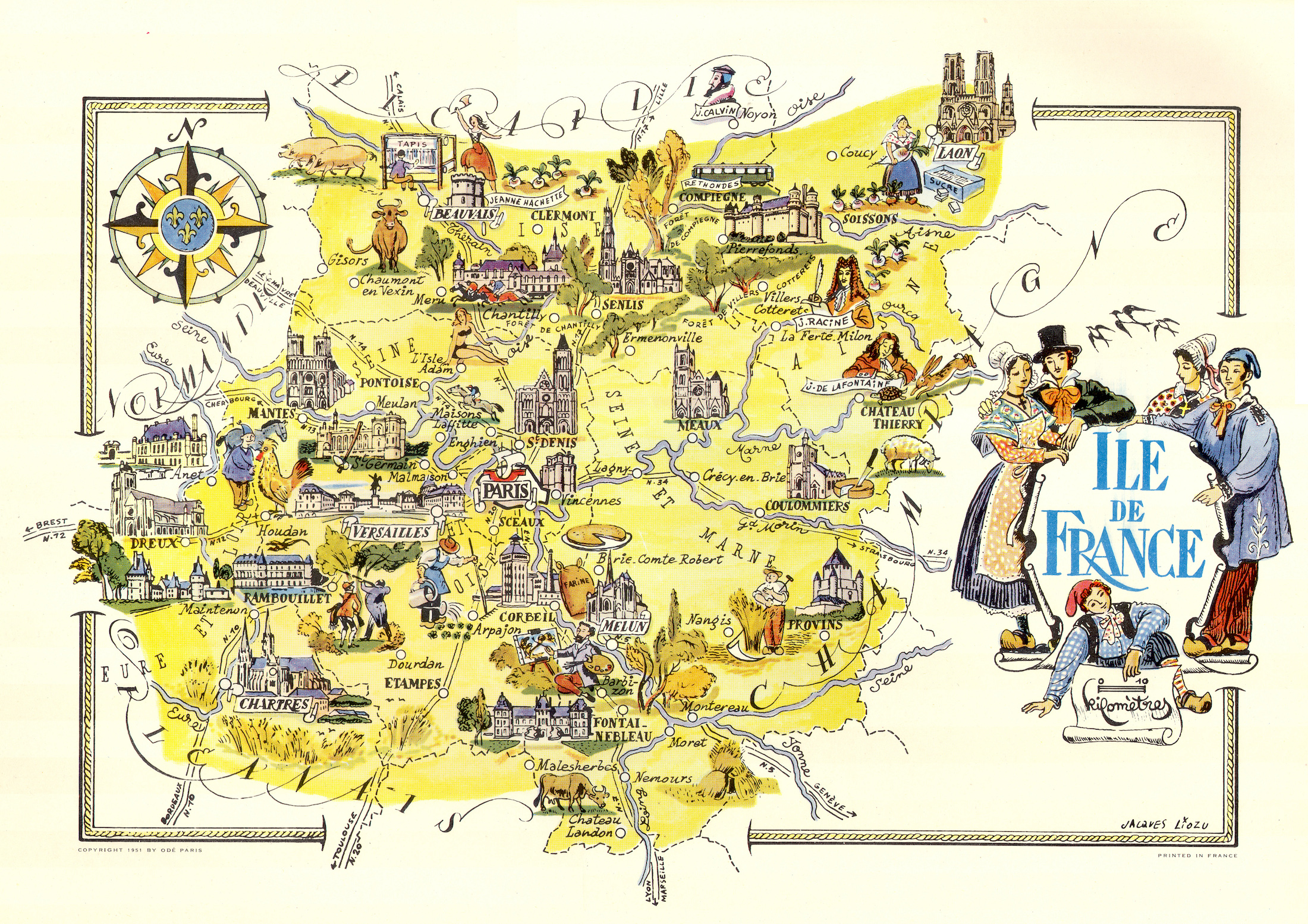
Color pictorial map of Ile de France and Paris covered with vignettes drawings of people and products of the province with explanation, representing region’s historical figures and events, resources, sights, churches, important buildings, people, activities, crops, etc. Includes decorative title cartouche and compass rose. Relief shown pictorially. Published by Ode Paris in 1951 from a drawn by Jaques Liozu.
- Dimension: 490 x 320 mm
- Place of publication: Paris
- Year: 1951