Importante grande incisione all’acquaforte con particolari al bulino di Orazio Farinati basato sul trittico del padre Paolo eseguito nel 1573 per la Chiesa dei Cappuccini a Verona. Terzo stato di cinque riconoscibile dalla data “1583” del I stato che qui stata corretta in “1593”; dall’aggiunta dell’indirizzo di Dall’Olio in basso al centro; dall’angolo del rame tagliato in basso a sinistra. [cod.1151/15]

Wirtenberg
Importante grande incisione all’acquaforte con particolari al bulino di Orazio Farinati basato sul trittico del padre Paolo eseguito nel 1573 per la Chiesa dei Cappuccini a Verona. Terzo stato di cinque riconoscibile dalla data “1583” del I stato che qui stata corretta in “1593”; dall’aggiunta dell’indirizzo di Dall’Olio in basso al centro; dall’angolo del rame tagliato in basso a sinistra. [cod.1151/15]
- Year: 1616
- Dimension: 190 x 146 mm
- Place of publication: Amsterdam
€ 110,00
Related products
-
![]()
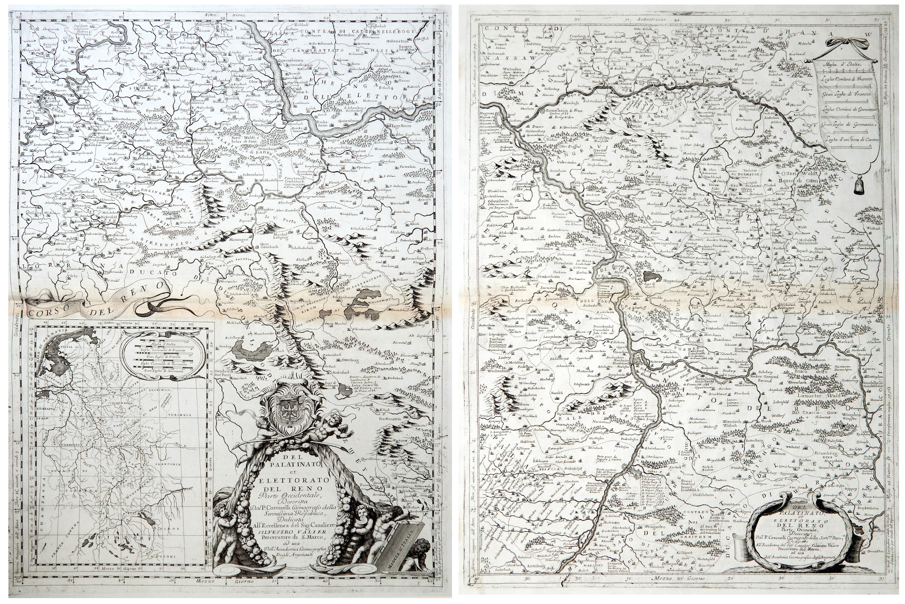
Del Palatinato et Elettorato del Reno parte Occidentale… / Del Palatinato et Elettorato del Reno parte Orientale
More Info € 600,00Very detailed and decorative map in two sheets of Rhine Valley from Coronelli’s Corso Geografico Universale published in Venice in 1690. Inset map of the entire River. Vincenzo Maria Coronelli is widely recognised as one of Italy?s most famous and greatest cartographers. He received an ecclesiastical education at the convent of the Minor Conventuals and also studied theology in Rome. However, his interests in geography and cartography were awoken early in his ecclesiastical career and never supp
- Year: 1690
- Dimension: 605 x 450 mm each
- Place of publication: Venice
-
![]()
Very detailed and decorative map in two sheets of Cologne showing in great care the course of Rhine from Coronelli’s Corso Geografico Universale published in Venice in 1690. Vincenzo Maria Coronelli is widely recognised as one of Italy?s most famous and greatest cartographers. He received an ecclesiastical education at the convent of the Minor Conventuals and also studied theology in Rome. However, his interests in geography and cartography were awoken early in his ecclesiastical career and neve
- Year: 1690
- Dimension: 450 x 610 mm each
- Place of publication: Venice
-
![Germany Vintage Pictorial map]() Out of stock
Out of stockColor pictorial map, with decorative border and title cartouche over compass rose. Shows vignettes of landmarks and buildings, vessels and steam boats, rivers and mountains. Includes inset 8 vignettes showing allegories of science, transport, aeronautics, technics, art, architecture, sport and music. Published by Reichsbahnzentrale fur den Deutschen Reisenverkher in Berlin at Erasmusdruck, 1930.
- Dimension: 58 x 42 cm
- Place of publication: Berlin
- Year: 1930
-
![]()
Lower Saxony and Mecklenburg are the central theme of this appealing map. It covers from Lubeck and the Baltic Sea in the north to Celle, Rathenow and Spandau in the south. Adorned with strapwork title and scale cartouches. From the Mercator Hondius “Atlas Minor” published in Amsterdam in 1648 at Jannsonius. In 1607 Jodocus Hondius published a reduced size version of Mercator’s “Atlas”, itself suitably titled “Atlas Minor”. The maps were …
- Year: 1648
- Dimension: 195 x 145 mm
- Place of publication: Amsterdam