Paris
Showing 25–36 of 47 results
-
![]()
Striking nautical lithograph drawn and lithographed by C. Dubreuil. Printed in Paris by Jacomme, circa 1860. From Album Maritime. An attractive portrait of a French naval vessel. [cod.1080/15]
- Year: 1860
- Dimension: 485 x 320 mm
- Place of publication: Paris
-
![]()
The very rare card showing the card number 9 of Lombardy in northern Italy (9 cities Angera, Novara, Vigevano, Valenza, Mortara, Sesto Calende, Binasco etc..) providing some geographical information on rivers, lakes and towns (and their distance in miles to Rome). Published by Nicholas De Poilly in Paris in 1763. A collector’s items.
From a pack of playing cards where the value of each card is indicated by the number of towns on it, and each suit by the colour. The court cards, bearing heads of kings, queens and knaves, have statistical details inside a panel of hanging drapery. Cfr. British Museum 1906,0723.36.1-51- Year: 1763
- Dimension: 60 x 80 mm
- Place of publication: Paris
-
![]()
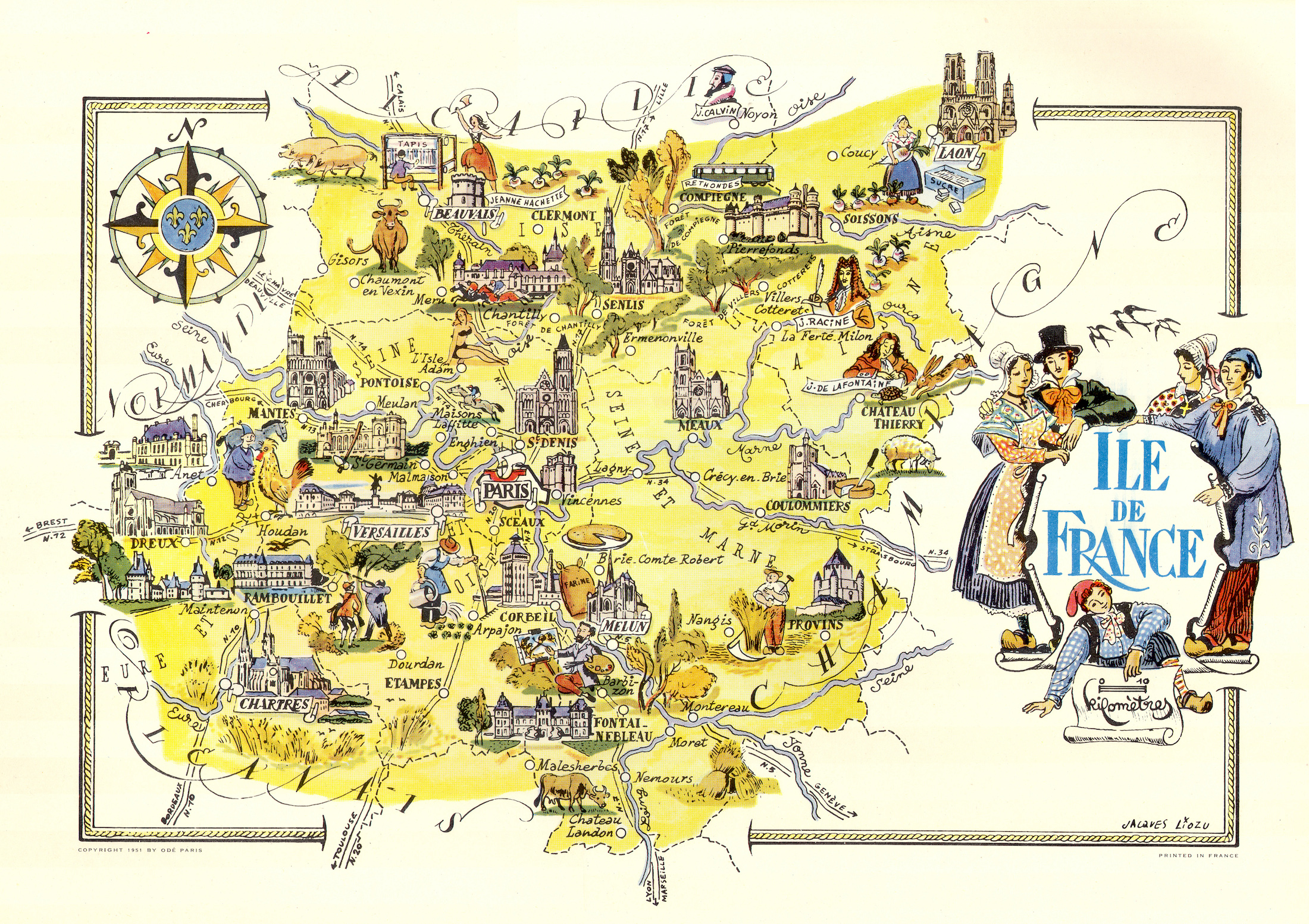
Color pictorial map of Ile de France and Paris covered with vignettes drawings of people and products of the province with explanation, representing region’s historical figures and events, resources, sights, churches, important buildings, people, activities, crops, etc. Includes decorative title cartouche and compass rose. Relief shown pictorially. Published by Ode Paris in 1951 from a drawn by Jaques Liozu.
- Dimension: 490 x 320 mm
- Place of publication: Paris
- Year: 1951
-
![]() Out of stock
Out of stockA lovely and uncommon map of Southeast Asia showing the French Indochina published in Paris by the pharmaceutical laboratories Neutroses-Vichy in 1939 at Petit Jean. Laos, Cambodia and Vietnam are symbolized by small vignette.
- Dimension: 310 x 210 mm
- Place of publication: Paris
- Year: 1939
-
![]()
Interesting map of Scotland engraved on copper by Glot. Inset the Shetland. From the scarce “Atlas Portatif, contenant la Gographie Universelle Ancienne et Moderne” by Eustache Herisson published in Paris in 1809 at Desray.
- Year: 1809
- Dimension: 213 x 182 mm
- Place of publication: Paris
-
![]()
L’Europe Divisee en touttes ses Regiones et Grand Estats… Par J.B. Nolin corrigee l’an 3 par Longchamps
More Info € 500,00The rare map of Europe prepared by J. Nolin and re-issued by Basset corrected and improved during “l’An 3 de la Republique Francaise” by Longchamps. It comes with two columns on the left and right side describing the different regions and empires.
- Year: 1795
- Dimension: 470 x 650 mm
- Place of publication: Paris
-
![]()
The very rare card showing the card number 8 of Lombardy in northern Italy (Pavia, Voghera, Varzo, Bobbio, Serravalle Scrivia, Tortona, Alessandria e Lumello) providing some geographical information on rivers, lakes and towns (and their distance in miles to Rome). Published by Nicholas De Poilly in Paris in 1763. A collector’s items.
From a pack of playing cards where the value of each card is indicated by the number of towns on it, and each suit by the colour. The court cards, bearing heads of kings, queens and knaves, have statistical details inside a panel of hanging drapery. (see other similar items in my store). Cfr. British Museum 1906,0723.36.1-51- Year: 1763
- Dimension: 60 x 80 mm
- Place of publication: Paris
-
![]()
A beautiful 1917 French propaganda postcard showing in a satirical manner the German territorial expansion in Europe in the form of an octopus.
- Dimension: 90 x 140 mm
- Place of publication: Paris
- Year: 1917
-
![]() Out of stock
Out of stockThe very rare card showing Verona as queen of the Kingdom of Venice. It provides some geographical information on the city.
Published by Nicholas De Poilly in Paris in 1763. A collector’s items.
From a pack of playing cards where the value of each card is indicated by the number of towns on it, and each suit by the colour. The court cards, bearing heads of kings, queens and knaves, have statistical details inside a panel of hanging drapery. Cfr. British Museum 1906,0723.36.1-51- Year: 1763
- Dimension: 60 x 80 mm
- Place of publication: Paris
-
![]()
Les divers archipels de l’Oceanie. [inset] Groupe de la Nouvelle Caledonie. [inset] Archipel des Iles Sandwich.
More Info € 100,00Very detailed map of the Pacific Ocean with insets of Hawaii and New Caledonia. From Atlas Spheroidal et Universel de Geographie by M.F.A. Garnier published in Paris at Veuve Jules Renouard in 1862. This atlas is exceptional for its “spheroidal” maps of the globe, showing the various continents and poles, shaded to give the effect of a sphere floating in space. The remaining maps are also very well executed and colored. This is the only…
- Year: 1862
- Dimension: 350 x 490 mm
- Place of publication: Paris
-
![]()
Color pictorial map of Limousin and Marche covered with vignettes drawings of people and products of the province with explanation, representing region’s historical figures and events, resources, sights, churches, important buildings, people, activities, crops, etc. Includes decorative title cartouche and compass rose. Relief shown pictorially. Published by Ode Paris in 1951 from a drawn by Jaques Liozu.
- Dimension: 490 x 340 mm
- Place of publication: Paris
- Year: 1951
-
![]() Out of stock
Out of stockThe very rare card showing the map of Lombardy in northern Italy as ace in a deck of playing geographical card game. Published by Nicholas De Poilly in Paris in 1763. A collector’s items.
From a pack of playing cards where the value of each card is indicated by the number of towns (read my article in the blog section) on it, and each suit by the colour. The court cards, bearing heads of kings, queens and knaves, have statistical details inside a panel of hanging drapery. Cfr. British Museum 1906,0723.36.1-51- Year: 1763
- Dimension: 60 x 80 mm
- Place of publication: Paris