Portugal
Showing all 6 results
-
![]()
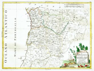
[Portugal] Il Portugallo Cioe Le Provincie di Entredouro, e Minho, Traz-Os-Montes, e Beira Di Nuova Projezione
More Info € 150,00Map of the northern half of Portugal, with attractive cartouche at lower right, showing moored ship with its cargo of barrels unloaded on the shore, next to a stone tablet on which is written the title. From Atlante Novissimo, illustrato ed accresciuto sulle osservazioni, e scoperte fatte dai più celebri e più recenti cartografi by Antonio Zatta published in Venice in 1779. Antonio Zatta was one of the leading cartographers and publishers of the time,…
- Year: 1779
- Dimension: 320 x 420 mm
- Place of publication: Venice
-
![]()
Detailed map of Portugal oriented with the north to the right from the Mercator Hondius Atlas Minor published in Amsterdam in 1648 at Jannsonius with german text on verso. In 1607 Jodocus Hondius published a reduced-size version of Mercator’s “Atlas”, itself suitably titled “Atlas Minor”. The maps were copied from those of the great cartographer Mercator of around 1580-90 or were reductions of Hondius’ own maps of 1606. Almost 20 years later Joannes Janssonius commissioned…
- Year: 1648
- Dimension: 203 x 140 mm
- Place of publication: Amsterdam
-
![]()
A fine miniature map of Portugal from “Theatro del Mondo” the famous plagiarised version of Ortelius’ pocket atlas published specifically for the Italian market by Pietro Marchetti. First printed in Brescia this is the rare Venetian edition of 1667. Italian text on verso.
- Year: 1667
- Dimension: 75 x 105 mm
- Place of publication: Venice
-
![]()
Fine map of Portugal oriented with west at the top (and north incorrectly pointing south on the compass rose) from Corso Geografico Universale by Vincenzo Coronelli published in Venice, 1690. A decorative title cartouche appears in bottom center embellished with military flags and canon. The scales cartouche and the arms of Portugal and Algarve are supported by mermen in the Atlantic and four smaller crests represent the adjacent regions of Spain. At bottom right the…
- Year: 1690
- Dimension: 594 x 444 mm
- Place of publication: Venice
-
![]()
Carte itineraire physique politique et routiere de l’Espagne et du Portugal: indiquant les trois grandes Regions geographiques les ancines et les nouvelles Divisions
More Info € 600,00This extremely uncommon carte-a-figures map from the 19th century features the Iberian Peninsula and is surrounded with defly engraved figures and representations of places of note in Spain and Portugal. The vignettes flanking the map include Alhambra, Malaga, The Giralda Bell Tower of the Cathedral of Seville, Burgos Cathedral, Tower of Orangers in Seville, St. Nicholas’s Tower in Cordova, the Carmel Convent, Madrid, Lisbon and El Prado in addition to others. The figures below the map include a bull fighter and typical attire for residents of various parts of Spain and Portugal. The map is filled with details of roads, towns and cities, as well as topography and was made as a folding map to assist travelers in the region.
- Dimension: 53,5 x 73 cm
- Place of publication: Paris
- Year: 1840
-
![]()
Uncommon and elegant Italian map by Filippo Naymiller showing Spain and Portugal published in Milan. Includes a second sheet of text embellished by vignettes of Madrid and Lisbona engraved by Baldi. It provides really interesting geographical and statistical information of the Countries. The map was finely engraved by Pietro Allodi. From Atlante di geografia universale: cronologico, storico, statistico e letterario Milan, 1860 at Litografia Pagnoni.
- Dimension: 32 x 42 cm
- Place of publication: Milan
- Year: 1860