Asia
Showing all 4 results
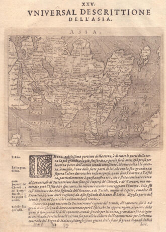
-
![]()
Miniature map from “Neu aussgeffertigter kleiner Atlas” by J. Muller published in Franckfurt in 1702 at Johann Philip Andrea. Engraved with great care by G. Karsch e G. Bodeneher. Rare.
- Year: 1702
- Dimension: 70 x 80 mm
- Place of publication: Frankfurt
-
![]()
Fascinating map of Asia based on Ortelius’with the exception of the addition of a strait dividing the southern portion of the Malay Peninsula. Interesting depiction of Japan, no sign of the Korean Peninsula. Includes region south of Nova Guinea that is marked as Terrae Incognita Australis, separated from Nova Guinea by a narrow channel. Engraved by Girolamo Porro for “Geografia di Claudio Tolomeo” by Giovanni Antonio Magini published in Padua, 1621.
- Year: 1621
- Dimension: 14 x 18 cm
- Place of publication: Padova
-
![asia map meyer]()
Lovely engraved map based on the cartography by C. Franz Radefeld (1788-1874) showing the whole Asia. From the “Meyer’s Neuester Zeitungs Atlas” published by Bibliographischen Instituts in Hildburghausen in 1849-52. The innovation of this work is that almost all maps had small inserts showing richly detailed maps of major cities and their surrunding areas: so not only could travellers carry the atlas with them easily, they could also obtain an initial orientation to their destination…
- Year: 1849
- Dimension: 180 x 220 mm
- Place of publication: Hildburghausen
-
![]()
A map of the whole of Asia, with decorative figured cartouche. From ‘Atlante Novissimo’.
- Year: 1779
- Dimension: 305 x 405 mm
- Place of publication: Venice