Fine example of Ganier’s decorative map of Argentina, Patagonia, Chile, Uruguay, Paraguay, Bolivia, and parts of Bresil and Peru.From Atlas Spheroidal et Universel de Geographie by M.F.A. Garnier published in Paris at Veuve Jules Renouard in 1862. This atlas is exceptional for its “spheroidal” maps of the globe, showing the various continents and poles, shaded to give the effect of a sphere floating in space. The remaining maps are also very well executed and colored. This is the only atlas that Garnier produced, according to Phillips. (836) [cod.1091/15]
- Sorry, this product cannot be purchased.

Republique Argentine, ou Provinces-Unies de la Plata
- Year: 1862
- Dimension: 500 x 360 mm
- Place of publication: Paris
€ 120,00
Related products
-
![]()
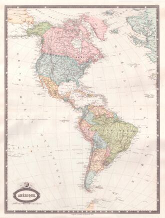
Interesting map of America with high detail and beautiful decorative colouring. The Panama Canal has not yet been built. Colombia is “Nouvelle Grenade” and Alaska is “Amerique Russe”. Much of the Amazon is labeled as “Selvas”, or tropical rainforests, and “Région Inconnue”. From Atlas Spheroidal et Universel de Geographie by M.F.A. Garnier published in Paris at Veuve Jules Renouard in 1862. This atlas is exceptional for its “spheroidal” maps of the globe, showing the various…
- Year: 1862
- Dimension: 680 x 510 mm
- Place of publication: Paris
-
![]()
Charming classical pocket map of Pacific coast of Mexico. From the Mercator Hondius “Atlas Minor” published in Amsterdam in 1648 at Jannsonius with german text on verso. In 1607 Jodocus Hondius published a reduced size version of Mercator’s “Atlas”, itself suitably titled “Atlas Minor”. The maps were copied from those of the great cartographer Mercator of around 1580-90 or were reductions of Hondius’ own maps of 1606. Almost 20 years later Joannes Janssonius commissioned a…
- Year: 1648
- Dimension: 190 x 135 mm
- Place of publication: Amsterdam
-
![]()
Paraguay o Prov. De Rio De La Plata cum regionibus adiacentibus Tucuman et Sta. Cruz De la Sierra
More Info € 140,00Early pocket map of the Rio de La Plata region in Uruguay showing also part of Argentina from the Mercator Hondius “Atlas Minor” published in Amsterdam in 1648 at Jannsonius with german text on verso. In 1607 Jodocus Hondius published a reduced size version of Mercator’s “Atlas”, itself suitably titled “Atlas Minor”. The maps were copied from those of the great cartographer Mercator of around 1580-90 or were reductions of Hondius’ own maps of 1606. Almost 20 years later Joannes Janssonius commi
- Year: 1648
- Dimension: 193 x 145 mm
- Place of publication: Amsterdam
-
![]()
Carte De L’Amerique Septenrionale et Meridionale … les Decourverts Les plus nouvelles et les trois Voyages de Cook, MacKenzie et Vancouver…1809
More Info € 800,00Rare map of America and the discoveries in the Pacific Ocean. Published separately by Eustace Herisson in Paris in 1809 at Bisset. The map shows a large and detailed map of the Americas, the Pacific, New Zealand and the Atlantic Ocean with engraved routes of explorations of Cook, Vancouver and Mackenzie. [cod.1233/15]
- Year: 1809
- Dimension: 760 x 520 mm
- Place of publication: Paris