Striking map of Myanmar (Burma) Thailand, Cambodia, Vietnam and Malaysia, with decorative title cartouche engraved by Giuseppe Pitteri. The map was issued in Zatta’s Atlante Novissimo, a monumental 4 volume work and one of the last great decorative atlases. Features a striking cartouche.

Regni D’Aracan del Pegu di Siam de Camboge e di Laos
- Year: 1779
- Dimension: 410 x 325 mm
- Place of publication: Venice
€ 400,00
Related products
-
![]()
Very detailed small map showing the region from India through southern China and the Philippines, and includes all of the Malaysian Peninsula with parts of North Sumatra and Borneo. In India, the Bay of Cambray is very exaggerated. The mythical Chiamai Lacus appears northeast of India, along with two large lakes in China. From the Mercator Hondius “Atlas Minor” published in Amsterdam in 1648 at Jannsonius. In 1607 Jodocus Hondius published a reduced size version…
- Year: 1648
- Dimension: 195 x 144 mm
- Place of publication: Amsterdam
-
![]()
Delightful small map of the ancient Turkish empire covering the Middle East (including Arabia and Oman) from the Mercator Hondius “Atlas Minor” published in Amsterdam in 1648 at Jannsonius with german text on verso. In 1607 Jodocus Hondius published a reduced size version of Mercator’s “Atlas”, itself suitably titled “Atlas Minor”. The maps were copied from those of the great cartographer Mercator of around 1580-90 or were reductions of Hondius’ own maps of 1606. Almost…
- Year: 1648
- Dimension: 190 x 130 mm
- Place of publication: Amsterdam
-
![]()
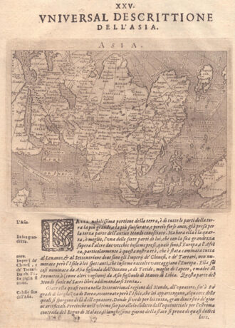
A map of the whole of Asia, with decorative figured cartouche. From ‘Atlante Novissimo’.
- Year: 1779
- Dimension: 305 x 405 mm
- Place of publication: Venice
-
![]()
Fascinating map of Asia based on Ortelius’with the exception of the addition of a strait dividing the southern portion of the Malay Peninsula. Interesting depiction of Japan, no sign of the Korean Peninsula. Includes region south of Nova Guinea that is marked as Terrae Incognita Australis, separated from Nova Guinea by a narrow channel. Engraved by Girolamo Porro for “Geografia di Claudio Tolomeo” by Giovanni Antonio Magini published in Padua, 1621.
- Year: 1621
- Dimension: 14 x 18 cm
- Place of publication: Padova